wild rhododendrons blooming at tokette lake campground in the cascade mountains of oregon; enjoy camping in the umpqua national forest and hiking trails to waterfalls in the wild and scenic umpqua river watershedt: brice creek waterfalls, moon waterfalls, pinard waterfalls, spirit falls; hiking trails off the Rogue Umpqua Scenic byway on the wild and scenic umpqua river in the umpqua national forest: toketee waterfalls, watson falls hiking trails, fall creek falls, susan creek day use area, susan creek hiking trails, susan creek campgrounds off the rogue umpqua scenic byway, toketee campgrounds off the rogue umpqua scenic byway, lemolo campgrounds off the rogue umpqua scenic byway, diamond lake campgrounds, boulder creek campgrounds, canyon creek campgrounds, umpqua national forest campgrounds, clearwater falls campgroud, island campgrounds, lake in the woods campgrounds, bogus creek campgrounds, apple creek campground, steamboat falls campground, williams creek and eagle rock campgrounds, horseshoe bend and canton creek campgrounds, devil's campground on cow creek, cedar creek campground on brice creek, rujada campground on layng creek, whitehorse falls and clearwater falls campgrounds, susan creek waterfalls, north umpqua river, medicine creek native pictorgraphs, indian pictographs, south umpqua river, umpqua river hiking trails accessed off the rogue umpqua scenic byway, forest service campgrounds, blm campgrounds, cavitt creek recreation area, deadline falls, steelhead in the umpqua river, angling, hiking trails to lemolo waterfalls, clearwater waterfalls, whitehorse waterfalls, clearwater river, toketee lake, umpqua hot springs, steamboat creek waterfalls, warm springs waterfalls, lemolo lake; hiking trails on the little river in the umpqua river watershed in the umpqua national forest: wolf creek waterfalls, grotto falls, hemlock waterfalls, hemlock lake, cavitt creek waterfalls, recreation area, shadow waterfalls, yakso waterfalls; hiking trails on the south umpqua river watershed: south umpqua waterfalls, campbell waterfalls, hiking trails in the boulder creek wilderness area, hiking trails in the mt thielsen rogue umpqua divide wilderness area, old growth forests, cathedral waterfalls off the south umpqua river; hiking trails in the row river watershed: moon, spirit and pinard waterfalls.
Hiking Trails to
Waterfalls on the wild
and scenic Umpqua River

Precautions when hiking,
as stated by the Umpqua National Forest
and the Roseburg BLM

Only piped water at developed recreation areas should be considered safe to drink.

Know your limitations, and those of the other members of group, for steep or long trails.

Stay clear of wet, slippery rocks and vegetaion.

Remain aware of your surroundings when taking photographs. Don't startle other photgraphers around steep terrain.

Do not stray from fenced observation points or trails in steep areas.

Keep on top of current and seasonal conditions of roads and trails leading to waterfalls. Contact the Forest Service or BLM offices: North Umpqua Ranger Station: 541-496-3532, Toketee Ranger Station: 541-498-2531; Roseburg BLM: 541-440-4930, for questions.

Beware of poison oak. Want to see a picture?

Following the trail through the split boulder, hiking to Falls Creek Waterfalls, pictured to the left.

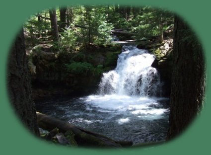
Hiking trails for waterfalls on the north Umpqua River

Directions for all these hiking trails begin at Roseburg, Oregon. Roseburg is located on I - 5. Map of this segment of the Rogue Umpqua Scenic Byway.

Deadline Falls on the Tioga segment of the North Umpqua River Hiking Trail

Directions: Turn south at milepost 21.9 on Hwy 138, cross Swiftwater Bridge. Immediately turn left into trailhead parking area. This is the beginning of the Tioga segment of the North Umpqua River Hiking Trail. Walk .25 mile, keeping your eye on the river. You'll see the falls, and a side trail that leads to Deadline Falls Watchable Wildlife Site. This trail is wheelchair accessible and popular with seniors and families with children. Between May and October salmon and steelhead may be observed jumping up the powerful falls to spawn in the upstream tributaries.

Deadline Falls is under the auspices of the BLM.

Nearby Attractions: Swiftwater Day-Use Area, Swiftwater County Park, Rock Creek Fish Hatchery, the Susan Creek Recreation Area, also under the auspices of the BLM.

To see photographs: Dealine Falls page 1 and page 2.

Susan Creek Waterfalls hiking trail

Directions: The trailhead is clearly marked from the road at milepost marker 28.2. Turn north into the large parking area. The trail to the waterfall is .8 mile. It's wheelchair accessible at a moderately difficult level. After reaching the waterfall, hikers can continue on a more difficult trail that is not wheelchair accessible .4 mile to the Susan Creek Indian Mounds.

Susan Creek Waterfall and hiking trails are under the auspices of the Roseburg BLM.

Nearby Attractions: Susan Creek Day Use Area, Susan Creek Campground and Fall Creek Waterfall.

Restrooms are available at the trailhead.

To see photographs of Susan Creek Waterfall Recreation Area: page 1, page 2 and page 3: Susan Creek Campground.

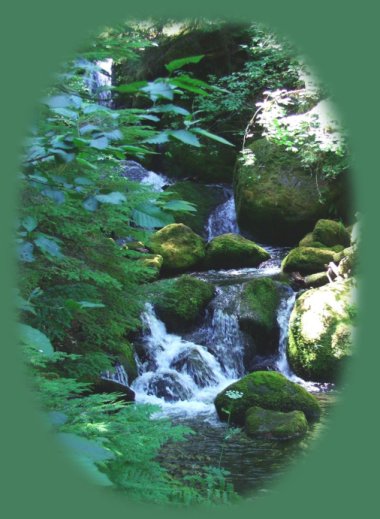
Fall Creek Waterfalls hiking trail

Directions: Turn north at milepost marker 32.2 on Hwy 138. Be on the lookout for it, for it's on the eastern side of a slight curve. There's a left turn lane, so you don't need to concern yourself about anyone behind. You just might like to be ready to turn. :-)

This hiking trail is 1.0 mile and rated more difficult, but every bit of this hike is a joy. I'm not kidding. From the bridge that leads to the trail from the parking lot, the split boulder you walk through near the beginning of the hike, the various small falls as the creek skips down the mountain, the lush ferns, and finally the waterfall. This is a truly great hike. All the waterfalls are pretty, and all the hikes are good, but some are even better.

It's possible to take a short side trail off this trail to Job's garden. It's marked with a sign. Of all places, be watchful for poison oak on this trail! Also, the last time I was there, the columnar basalt had done what rock always does, the columns were broken and the basalt lay in the tumbled mess ... So goes all mountains.

Fall Creek Waterfalls and hiking trails are under the auspices of the North Umpqua Ranger Station of the Umpqua National Forest

clearwater river in the umpqua national forest; enjoy camping in the umpqua national forest and hiking trails to waterfalls in the wild and scenic umpqua river watershedt: brice creek waterfalls, moon waterfalls, pinard waterfalls, spirit falls; hiking trails off the Rogue Umpqua Scenic byway on the wild and scenic umpqua river in the umpqua national forest: toketee waterfalls, watson falls hiking trails, fall creek falls, susan creek day use area, susan creek hiking trails, susan creek campgrounds off the rogue umpqua scenic byway, toketee campgrounds off the rogue umpqua scenic byway, lemolo campgrounds off the rogue umpqua scenic byway, diamond lake campgrounds, boulder creek campgrounds, canyon creek campgrounds, umpqua national forest campgrounds, clearwater falls campgroud, island campgrounds, lake in the woods campgrounds, bogus creek campgrounds, apple creek campground, steamboat falls campground, williams creek and eagle rock campgrounds, horseshoe bend and canton creek campgrounds, devil's campground on cow creek, cedar creek campground on brice creek, rujada campground on layng creek, whitehorse falls and clearwater falls campgrounds, susan creek waterfalls, north umpqua river, medicine creek native pictorgraphs, indian pictographs, south umpqua river, umpqua river hiking trails accessed off the rogue umpqua scenic byway, forest service campgrounds, blm campgrounds, cavitt creek recreation area, deadline falls, steelhead in the umpqua river, angling, hiking trails to lemolo waterfalls, clearwater waterfalls, whitehorse waterfalls, clearwater river, toketee lake, umpqua hot springs, steamboat creek waterfalls, warm springs waterfalls, lemolo lake; hiking trails on the little river in the umpqua river watershed in the umpqua national forest: wolf creek waterfalls, grotto falls, hemlock waterfalls, hemlock lake, cavitt creek waterfalls, recreation area, shadow waterfalls, yakso waterfalls; hiking trails on the south umpqua river watershed: south umpqua waterfalls, campbell waterfalls, hiking trails in the boulder creek wilderness area, hiking trails in the mt thielsen rogue umpqua divide wilderness area, old growth forests, cathedral waterfalls off the south umpqua river; hiking trails in the row river watershed: moon, spirit and pinard waterfalls.

Nearby Attractions: Susan Creek Recreation Area, including the hiking trail to Susan Creek waterfall, the day use area and the campground, Bogus Creek Campground and Wright Creek Trailhead on the North Umpqua River Hiking Trail.

A flush toilet is available at the trailhead. For hikers only.

To see photographs of Fall Creek Waterfalls: page 1 and page 2.

Steamboat Falls

This waterfall is located on Steamboat Road, FS Road 38, off of Hwy 138. It's west of Dry Creek, so if you get to Dry creek, you'll know you missed the turnoff. Directions: At milepost 38.3 on Hwy 138, turn north onto Steamboat Road. Drive 5.3 miles to Road 3810, turn right and stay to the left for .6 mile to the entrance of Steamboat Falls Campground.

These falls are quite lovely, spectacular in their own way. You need only walk 100 feet to see them.

Steamboat Creek, waterfalls and campgrounds are under the auspices of the North Umpqua Ranger Station of the Umpqua National Forest.

Nearby Attractions: Steamboat Inn, Canton Creek Campground - Canton Creek Campground is located on Canton Creek, turn left at the first turnoff on Steamboat Road to the campground. Island Campground is nearby on the Umpqua River. It's a very nice place if you like camping.

Picnicking and restrooms are available at the campground.

To see photographs of Steamboat Falls and the creek: page 1, the creek and Little Waterfalls, page 2, Steamboat Falls.

Toketee Waterfall hiking trail

Directions Turn north off the Rogue Umpqua Scenic Byway, Hwy 138, onto Toketee Rigdon Road. The turnoff to Toketee Watefall is marked from the highway, so when you get close to the 58.6 milepost marker, start looking for it. Cross the first bridge and turn left into the trailhead parking, which is easily recognized from the road. The north side is marked by an old, quite large, wooden pipe still used to funnel water. Something to do with the dam.

Toketee is the most beautiful waterfall of all. This isn't simply my opinion. Anyone I've ever asks, agrees it is the best. Indeed, I have friends coming from the Netherlands this summer. We have a limited amount of time. Toketee and Watson Waterfalls are the two hikes I've planned for the tour on the Umpqua River. We'll stop and see Whitehorse and Clearwater; they don't involve any hike at all, and Clearwater Falls is one of my favorites also. But Toketee Waterfall ... Toketee means pretty and graceful in the Chinook language. It's so hard to pick one over any other, but if you had to pick only one, pick Toketee Waterfalls. Definitely.

The trail is .4 mile. It's rated more difficult, and most likely that's because of the stairs. There are many, many stairs, going up and down.

Toketee waterfalls and hiking trail is under the auspices of the Umpqua National Forest.

Nearby Attractions: Toketee Lake Campground, Umpqua Hot Springs (very popular), Toketee Ranger Station and Watson Falls.

Restrooms, vault toilets, are available at the trailhead, and there is a picnic table also. This hiking trail is developed for hikers only.

To see photographs of Toketee Waterfall: page 1, the Umpqua River canyon on the trail and page 2, Toketee Waterfall - Nature's Cathedral.

hiking trails in the umpqua national forest; enjoy camping in the umpqua national forest and hiking trails to waterfalls in the wild and scenic umpqua river watershedt: brice creek waterfalls, moon waterfalls, pinard waterfalls, spirit falls; hiking trails off the Rogue Umpqua Scenic byway on the wild and scenic umpqua river in the umpqua national forest: toketee waterfalls, watson falls hiking trails, fall creek falls, susan creek day use area, susan creek hiking trails, susan creek campgrounds off the rogue umpqua scenic byway, toketee campgrounds off the rogue umpqua scenic byway, lemolo campgrounds off the rogue umpqua scenic byway, diamond lake campgrounds, boulder creek campgrounds, canyon creek campgrounds, umpqua national forest campgrounds, clearwater falls campgroud, island campgrounds, lake in the woods campgrounds, bogus creek campgrounds, apple creek campground, steamboat falls campground, williams creek and eagle rock campgrounds, horseshoe bend and canton creek campgrounds, devil's campground on cow creek, cedar creek campground on brice creek, rujada campground on layng creek, whitehorse falls and clearwater falls campgrounds, susan creek waterfalls, north umpqua river, medicine creek native pictorgraphs, indian pictographs, south umpqua river, umpqua river hiking trails accessed off the rogue umpqua scenic byway, forest service campgrounds, blm campgrounds, cavitt creek recreation area, deadline falls, steelhead in the umpqua river, angling, hiking trails to lemolo waterfalls, clearwater waterfalls, whitehorse waterfalls, clearwater river, toketee lake, umpqua hot springs, steamboat creek waterfalls, warm springs waterfalls, lemolo lake; hiking trails on the little river in the umpqua river watershed in the umpqua national forest: wolf creek waterfalls, grotto falls, hemlock waterfalls, hemlock lake, cavitt creek waterfalls, recreation area, shadow waterfalls, yakso waterfalls; hiking trails on the south umpqua river watershed: south umpqua waterfalls, campbell waterfalls, hiking trails in the boulder creek wilderness area, hiking trails in the mt thielsen rogue umpqua divide wilderness area, old growth forests, cathedral waterfalls off the south umpqua river; hiking trails in the row river watershed: moon, spirit and pinard waterfalls.

Watson Falls hiking trail

Directions: Turn south at milepost marker 60.5 on the Rogue Umpqua Scenic Byway, Hwy 138. This is FS Road 37. The trailhead parking is on the right. The hiking trail to Watson Falls is .6 mile, uphill most of the way, and then downhill most of the way on the return trip. :-) It's rated more difficult - because it's uphill I think. If you can't make the climb, the waterfall can be viewed from a footbridge .3 mile from the trailhead. It's certainly worth the walk just to see it. Watson Waterfall is magnificent. If plunges 272' over basaltic cliffs that seem reminscent of an amphitheater in size and shape.

Watson Falls is under the auspices of Toketee Ranger Station of the Umpqua National Forest

Nearby Attractions: Toketee Falls, Toketee Lake Campground.

Vault toilets are available at the trailhead as well as picnic tables. For hikers only.

To see photographs of Watson Waterfall: page 1, & page 2.

Whitehorse Waterfalls

Directions: Turn north at milepost marker 65.9 on Hwy 138, or the Rogue Umpqua Scenic Byway, and drive into the campground. One can view the falls from the parking lot, but it's just a slight walk downhill to get a frontal view. This waterfall is charming

Whitehorse Waterfall is under the auspices of the Toketee Ranger Station of the Umpqua National Forest.

Nearby Attractions: Toketee Waterfall, Toketee Lake Campground, Watson and Clearwater Waterfalls.

Vault toilets are available in the parking area.

To see photographs of Whitehorse Waterfalls: See Whitehorse Falls page with description of campground and picnic area.

Clearwater Falls

DirectionsTurn south at milepost marker 36.5 at the entrance Clearwater Falls Campground. Follow the access road for .2 mile to the picnic area. The distance from the parking area to the falls is 400' - Very Easy.

Clearwater Falls is a beautiful waterfall, and as I said, one of my favorites. Much of the water that flows over the moss covered rocks surfaces from underground springs just before the waterfall falls.

Clearwater Campground can be found at a turnoff to the left found just before the parking lot for the waterfall and picnic area, as well as a mile down the highway.

This waterfall is under the auspices of the Toketee Ranger Station of the Umpqua National Forest.

Nearby Attractions: Lemolo Lake, Whitehorse Falls campground and Waterfall, Watson Falls, Toketee Waterfall.

Unless they've made improvements in the last couple of years, the toilet is an old outhouse. At least one is available. There are restrooms in the campground as well.

To see photographs of Clearwater Waterfall: page 1, to see a photograph of Clearwater River below the falls, see below.

clearwater river at clearwater falls; enjoy camping in the umpqua national forest and hiking trails to waterfalls in the wild and scenic umpqua river watershedt: brice creek waterfalls, moon waterfalls, pinard waterfalls, spirit falls; hiking trails off the Rogue Umpqua Scenic byway on the wild and scenic umpqua river in the umpqua national forest: toketee waterfalls, watson falls hiking trails, fall creek falls, susan creek day use area, susan creek hiking trails, susan creek campgrounds off the rogue umpqua scenic byway, toketee campgrounds off the rogue umpqua scenic byway, lemolo campgrounds off the rogue umpqua scenic byway, diamond lake campgrounds, boulder creek campgrounds, canyon creek campgrounds, umpqua national forest campgrounds, clearwater falls campgroud, island campgrounds, lake in the woods campgrounds, bogus creek campgrounds, apple creek campground, steamboat falls campground, williams creek and eagle rock campgrounds, horseshoe bend and canton creek campgrounds, devil's campground on cow creek, cedar creek campground on brice creek, rujada campground on layng creek, whitehorse falls and clearwater falls campgrounds, susan creek waterfalls, north umpqua river, medicine creek native pictorgraphs, indian pictographs, south umpqua river, umpqua river hiking trails accessed off the rogue umpqua scenic byway, forest service campgrounds, blm campgrounds, cavitt creek recreation area, deadline falls, steelhead in the umpqua river, angling, hiking trails to lemolo waterfalls, clearwater waterfalls, whitehorse waterfalls, clearwater river, toketee lake, umpqua hot springs, steamboat creek waterfalls, warm springs waterfalls, lemolo lake; hiking trails on the little river in the umpqua river watershed in the umpqua national forest: wolf creek waterfalls, grotto falls, hemlock waterfalls, hemlock lake, cavitt creek waterfalls, recreation area, shadow waterfalls, yakso waterfalls; hiking trails on the south umpqua river watershed: south umpqua waterfalls, campbell waterfalls, hiking trails in the boulder creek wilderness area, hiking trails in the mt thielsen rogue umpqua divide wilderness area, old growth forests, cathedral waterfalls off the south umpqua river; hiking trails in the row river watershed: moon, spirit and pinard waterfalls.

Warm Spring Falls hiking trail

Directions: Turn off the Rogue Umpqua Scenic Byway, Hwy 138, at milepost marker 72.8 onto road 2610. Drive approximately 6 miles. After the dam, turn left on Road 600. Drive about 3 miles to FS Road 680. Turn left and drive 1.7 miles to the trailhead for Warm Springs Trail, #1499.

The hike to Warm Springs waterfall is a very easy walk. I wouldn't scarcely call it a hike. Nevertheless, the hiking trail is just .3 mile on level ground, and if you get there at the right time in June, the forest is blanketed in wild rhododenrons. It is SO beautiful. Regardless, it's beautiful no matter the time of year, falling over the same rock type of formations that help give Toketee its charm: columnar basalt.

Use Caution when nearing the edge of the bluffs. There are no guardrails.

This waterfall is under the auspices of the Toketee Ranger Station in the Umpqua National Forest.

Nearby Attractions: Lemolo Waterfall, Lemolo "Lake" and resort, Poole Creek Campground, and a few more as well ...

No restrooms. For hikers only. There is no access to the bottom of the falls.

To see photographs of Warm Springs Falls: page 1.

Lemolo Waterfall hiking trail

Lemolo Waterfall is also one of my favorites. :-)

Directions for the best view: Turn north off of the Rogue Umpqua Scenic Byway, Hwy 138, at milepost marker 72.8, onto FS Road 2610. Drive 4.2 miles. Turn left on FS Road 3401. Go about .5 mile, turn right at FS Road 3401-840. The trail is at the end of the road: .25 mile. The trail follows a series of switchbacks 1.7 miles down the side of the canyon to the Umpqua River below, anda most spectacular view of a waterfall that is amazing in its own right. The word "lemolo" is a Chinook term for wild and untamed, and so is this waterfall.

The hiking trail for Lemolo Falls is rated most difficult by the Umpqua National Forest.

The waterfall can also be viewed from the North Umpqua River Hiking Trail, but it's only a topside view. I give instructions for this segment of the North Umpqua Hiking Trail on the Lemolo Waterfall page if you're interested.

Lemolo Falls and all its environs falls under the auspices of the Umpqua National Forest.

Nearby Attractions: Lemolo "Lake" Resort, Poole Creek Campground, as well as others on the lake: Bunker Hill, Inlet and East Lemolo Campgrounds, the hiking trail to and Warm Springs Waterfall.

No restrooms. For hikers only.

To see photographs of Lemolo Watefall: page 1.

Protect our National Forests and Wilderness Areas. Leave NO Trace!

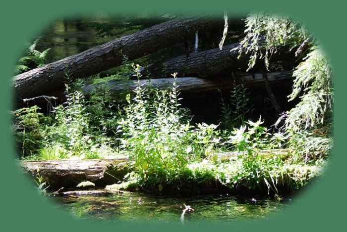
Forward ~ Hiking trails on the south Umpqua River.

Back ~ Hiking trails in the Little River watershed of the Umpqua River.

USFS: Umpqua National Forest. BLM: Roseburg
District of the Bureau of Land Management.

Plan your visit to the many waterfalls and hiking trails in the Umpqua National Forest.

Want to learn more about the campgrounds on the North Umpqua River and others in the Umpqua River watershed?

Foliage in Clearwater River, pictured on the right.

clearwater river in the umpqua national forest; enjoy camping in the umpqua national forest and hiking trails to waterfalls in the wild and scenic umpqua river watershedt: brice creek waterfalls, moon waterfalls, pinard waterfalls, spirit falls; hiking trails off the Rogue Umpqua Scenic byway on the wild and scenic umpqua river in the umpqua national forest: toketee waterfalls, watson falls hiking trails, fall creek falls, susan creek day use area, susan creek hiking trails, susan creek campgrounds off the rogue umpqua scenic byway, toketee campgrounds off the rogue umpqua scenic byway, lemolo campgrounds off the rogue umpqua scenic byway, diamond lake campgrounds, boulder creek campgrounds, canyon creek campgrounds, umpqua national forest campgrounds, clearwater falls campgroud, island campgrounds, lake in the woods campgrounds, bogus creek campgrounds, apple creek campground, steamboat falls campground, williams creek and eagle rock campgrounds, horseshoe bend and canton creek campgrounds, devil's campground on cow creek, cedar creek campground on brice creek, rujada campground on layng creek, whitehorse falls and clearwater falls campgrounds, susan creek waterfalls, north umpqua river, medicine creek native pictorgraphs, indian pictographs, south umpqua river, umpqua river hiking trails accessed off the rogue umpqua scenic byway, forest service campgrounds, blm campgrounds, cavitt creek recreation area, deadline falls, steelhead in the umpqua river, angling, hiking trails to lemolo waterfalls, clearwater waterfalls, whitehorse waterfalls, clearwater river, toketee lake, umpqua hot springs, steamboat creek waterfalls, warm springs waterfalls, lemolo lake; hiking trails on the little river in the umpqua river watershed in the umpqua national forest: wolf creek waterfalls, grotto falls, hemlock waterfalls, hemlock lake, cavitt creek waterfalls, recreation area, shadow waterfalls, yakso waterfalls; hiking trails on the south umpqua river watershed: south umpqua waterfalls, campbell waterfalls, hiking trails in the boulder creek wilderness area, hiking trails in the mt thielsen rogue umpqua divide wilderness area, old growth forests, cathedral waterfalls off the south umpqua river; hiking trails in the row river watershed: moon, spirit and pinard waterfalls.

 
Camping in the Umpqua National Forest
and those areas manged by the Roseburg BLM

Directions to campgrounds in the Diamond Lake District of the Umpqua National Forest. Directions to campgrounds in the North Umpqua River district. The campgrounds for both districts are off the Rogue Umpqua Scenic Byway, many are on the wild and scenic Umpqua River. All fall between the north entrance to Crater Lake National Park and I-5 at Roseburg, Oregon. Boulder Flat is the last one in the North Umpqua district. After that you're in the Diamond Lake District. Directions to campgrounds in the Little River watershed of the North Umpqua River. Directions to campgrounds on the south Umpqua River in the also in the Umpqua River watershed.

 
Hiking Trails in the Umpqua River watershed
in the Umpqua National Forest:

Directions for hiking trails to waterfalls and other points of interest in the Row River Watershed of the wild and scenic Umpqua River in the Umpqua National Forest. As well as Directions for the Umpqua River Trail - 12 hiking trails riverside. Directions for hiking trails to the many waterfalls on the wild and scenic Umpqua River off the Rogue Umpqua Scenic Byway. Directions for hiking trails in the south Umpqua watershed. Directions for hiking trails in the Little River watershed. All within the magnificent Umpqua National Forest.

Enjoy the North Umpqua Waterfalls Tour on the Rogue Umpqua Scenic Byway:

Can include Crater Lake National Park: Introduction.

Travel Directions, Map and Scenery ~ can include Crater Lake National Park: Introduction. Experience: splendid scenery, hiking trails for intrepid hikers and those with less enthusiam. Enjoy the magnificent the wild and scenic Umpqua River, the diversity of the Umpqua National forest, Umpqua hot springs near Toketee Campground, rafting on the rapids, hiking the beautiful trail along the Umpqua gorge to magnificent Toketee Waterfalls, my favorite, and the favorite of anyone I've ever spoken to. Hike through a forest garden of dense wild rhododendrons at Warm Spring Waterfalls. Hike the trails to experience the wonder of tumultuous Watson Falls. Don't forget Lemolo Waterfalls and Lemolo Lake. And when you arrive at the north entrance partake the splendor of Crater Lake - Enjoy beauty.

Enjoy the Diverse Loop Tour on the Rogue Umpqua Scenic Byway and the Crater Lake Hwy:

Includes Crater Lake National Park: Introduction.

Travel Directions, Map and Scenery. Experience: splendid scenery, hiking trails for intrepid hikers and those with less enthusiam, experience the majestic Rogue River Gorge at Union Creek and the Natural Bridge, waterfalls, the Rogue River Hiking Trail, hiking trails to Muir Creek Waterfalls and National Creek Waterfalls all in the Rogue - Siskiyou National Forest. Enjoy hiking trails to Mill Creek Waterfalls, Barr Creek Waterfalls and Pearsoney Waterfalls in Prospect, Oregon. Or just stand on the historic Prospect bridge and enjoy the panorama of the Avenue of Giant Boulders. Hike down to the water's edge if you've a mind to.

Combine the Umpqua Waterfalls and the Diverse Loop Tours

Traveling Oregon on the Rogue Umpqua Scenic Byway and the Crater Lake Hwy: Directions.

Travel Oregon and northern California while staying at Gathering Light ... a retreat
located in southern Oregon near Crater Lake National Park.

Travel the Rogue Umpqua Scenic Byway to the retreat: Directions Map & Scenery. Experience the grandeur of Toketee, Lemolo & Watson Falls, the wild & scenic Umpqua River & Crater Lake National Park.

Directions to & Day Trips of about 100 miles from the retreat.

Scenic Places: hiking, trails, wetlands, wildlife refuges, mountains, wilderness areas, river gorges & more near Crater Lake National Park & the retreat: Travel Directions, Map & Scenery.

Website Directory for the travel pages  Home Page

Page Listings to the travel pages

stay in the cabins at gathering light retreat in southern oregon near crater lake national park: cabins, treehouses on the river in the forest and travel oregon and experience volcanoes, geology, hiking trails, oregon geology, rogue siskiyou national forest, wild and scenic rogue river, wild and scenic umpqua river, rogue gorge at union creek, oregon, national rogue river hiking trail, rogue national forest, national forests, wilderness areas, national wildlife refuges, wetlands, klamath basin, prospect, oregon, mill creek waterfalls on the rogue river, barr creek waterfalls on the rogue river, avenue of giant boulders on the rogue river, hiking trails to mill creek waterfalls, hiking trails to barr creek waterfalls on the rogue river, hiking trails to national creek waterfalls in the rogue siskiyou national forest, hiking trails along the rogue river, hiking trails to the natural bridge, hiking trails at crater lake national park, crater lake national park, hiking trails on the wild and scenic rogue river, hiking trails to national creek waterfalls, national wildlife refuges, wetlands, rabbit ears, the cascade mountains, the old cascade mountains, mt thielsen, hiking trails at crater lake, crater lake national park.

Whitehorse Waterfall in the Umpqua National Forest, one of the day trips of about 100 miles from the retreat.

Contact Brad at Gathering Light ... a retreat.