|
Campgrounds in the Diamond
|
|
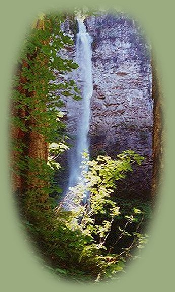
Important information when camping at any of the campgrounds below: The north entrance to Crater Lake Campground is on the other side of the entrance to Diamond Lake Campground on the Rogue Umpqua Scenic Byway. Diamond Lake Campground is located at the 80 milepost marker, so Crater Lake is within easy reach of any of these campgrounds. Campgrounds right off the Rogue Umpqua Scenic BywayToketee CampgroundDriving on the Rogue Umpqua Scenic Byway, Hwy 138, turn north at milepost marker 58.6 onto FS Road 34, Toketee Rigdon Road. This is the west access to Toketee Ranger Station (Diamond Lake District). Turn left at the bottom of the hill. Cross the concrete bridge on the right. Drive 1.5 miles to the campground entrance on the right. Toketee is one of my favorite places on earth. :-) The campground offers 33 campsites (tent and trailers to 30'), picnic tables, fireplaces, boat ramp and vault toilets. There is no drinking water. Things to do: The north entrance to Crater Lake National Park is about 20 miles east of the campground. Follow the Rogue Umpqua Scenic Byway, Hwy 138. Hwy 138 will diverge from the Rogue Umpqua Scenic Byway by the entrance to Diamond Lake. Stay on Hwy 138, turn north at the sign for Crater Lake National Park. The fee for 7 days is $10.00. As I mentioned above, the beautiful hiking trail to Toketee Waterfall is close at hand. Toketee in chinook jargon means pretty, graceful. The hiking trail for Watson Waterfalls is just a few miles east on the Rogue Umpqua Scenic Byway. The hiking trail to Umpqua Hot Springs is just down the road from the campground. The trail while rated difficult is only .3 mile. This trail is part of the North Umpqua River Trail, so you can go as far as you like. Also, a lovely hike can be had along Clearwater River, accessed at either the west or east entrance to Toketee Ranger Station. If you like to fish, Brown and Rainbow Trout can be had, and as mentioned above, the "Lake" has a boat ramp. Toketee Ranger Station is nearby, offering information and emergency medical services. Another thing you might not be aware of, you're not that far from Crater Lake when at Toketee. It's not close, but it's not far either. :-) 16.5 miles west on the Rogue Umpqua Byway, you can find a small grocery store, gasoline, propane, fishing supplies and a trailer park. For more information: USFS: Umpqua Ranger Station or call the Toketee Ranger Station: 541-498-2531. Whitehorse FallsDriving on the Rogue Umpqua Scenic Byway, Hwy 138, turn north at milepost 65.9. You'll see the sign "Whitehorse Falls". This is a lovely place, sheltered under old growth Douglas Fir, alongside the aply named Clearwater River. The campground offers 5 campsites, trailers up to 25' are allowed, picnic tables, fire rings and vault toilets. The picnic area offers 4 sites, picnic tables and fire rings. There is no drinking water. Things to do: The north entrance to Crater Lake National Park is at the most 18 miles east of the campground. Follow the Rogue Umpqua Scenic Byway, Hwy 138. Hwy 138 will diverge from the Rogue Umpqua Scenic Byway by the entrance to Diamond Lake. Stay on Hwy 138, turn north at the sign for Crater Lake National Park. The fee for 7 days is $10.00. In addition to this wonder - "there is no place like it on earth", Clearwater Falls campground, picnic area and viewpoint for the falls are 3 miles east on the Rogue Umpqua Scenic Byway. The hiking trails for Watson and Toketee Waterfalls are to the west on the Rogue Umpqua Scenic Byway, 2.5 and 5 miles respectively. The hiking trail to Umpqua Hot Springs can also be accessed in the Toketee area. A full service resort is available at Lemolo "Lake" 11.5 miles to the east off the Rogue Umpqua Scenic Byway. Clearwater WaterfallsDriving on the Rogue Umpqua Scenic Byway, Hwy 138, turn south at the 69.5 milepost marker. You'll see the Clearwater Falls Campground Sign. There are two areas for camping. The first area is to your left after you pass the entry sign. To get to the second location stay on the Rogue Umpqua Scenic Byway, and continue east for about 1 mile. Turn right onto FS Road 4785 for 1 mile. Camping area is off to the right. The campground offers: 12 campsites for tent and trailers up to 25', picnic tables, fire rings, vault toilets, as well as 8 picnic sites with tables and fire rings. There is no drinking water.. For more information: USFS: Umpqua National Forest: Cearwater Waterfalls, or call the Toketee Ranger Station: 541-498-2531. Things to do: The north entrance to Crater Lake National Park is at the most 15 miles east of the campground. Follow the Rogue Umpqua Scenic Byway, Hwy 138. Hwy 138 will diverge from the Rogue Umpqua Scenic Byway by the entrance to Diamond Lake. Stay on Hwy 138, turn north at the sign for Crater Lake National Park. The fee for 7 days is $10.00. In addition to that, Whitehorse Waterfalls, campground and picnic area, is about 4 miles to the west on the Rogue Umpqua Scenic Byway, Toketee Campground and the hiking trail to Toketee Falls is about 10 miles to the west, the hiking trail to Watson Falls is about 6 miles to the west. A full service resort is located 11.5 miles to the northeast at Lemolo Lake. The turnoff for Lemolo Lake is at milepost marker 72.8 on the Rogue Umpqua Scenic Byway, Hwy 138. | |
|
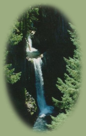
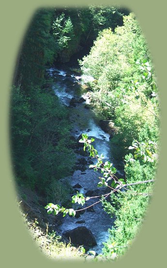
Lemolo "Lake" CampgroundsThings to do at Lemolo "Lake": The north entrance to Crater Lake National Park is located around the 80 mile marker on Hwy 138. Follow the Rogue Umpqua Scenic Byway, Hwy 138. Hwy 138 will diverge from the Rogue Umpqua Scenic Byway by the entrance to Diamond Lake. Stay on Hwy 138, turn north at the sign for Crater Lake National Park. The fee for 7 days is $10.00. More things to do at Lemolo "Lake": The reservoir offers much in the way of vacation recreation: Lemolo Lake Resort, as well as boating, fishing, water skiing, swimming; hiking trails to waterfalls, access to the Pacific Crest trail and the Umpqua River Trail. The hike to Toketee Waterfall is west within 15 miles from the turnoff of Hwy 138, to Watson Waterfalls: west within 10, & the opportunity to view and photograph Whitehorse & Clearwater Waterfalls: west within 5 and 7 respectively. The north entrance to Crater Lake is east within 20 miles of the turnoff from Hwy 138. (I'm estimating this distance, but if I'm off, it's not by much. I know this pass very well.- gm) Fishing: The lake contains Kokanee, Eastern Brook, and a few Rainbow trout. Large German brown trout are wild native fish and can be taken on troll and fly. The Umpqua River flows in the canyon below, pictured on the left. |
Lemolo "Lake" Campgrounds, continuedPoole Creek CampgroundPoole Creek campground lies at the mouth of Poole Creek on the western shore of Lemolo Lake. Lemolo Lake is 72 miles east of Roseburg, Oregon on the Rogue Umpqua Scenic Byway, Hwy 138. Turn north onto FS Road 2610; the turnoff is marked from the highway. Drive 4 miles and turn right when you see the Poole Creek Campground sign. A Northwest Forest Pass is required to use the boat ramp. The campground offers 59 campsites: tent, travel trailers up to 30' and RVs up to 35'. Tables are included, as well as fireplaces, running water, vault toilets, a boat ramp (Northwest Forest Pass required) and a swimming beach. A group camping area is also available. Reservations are required for this.. To make reservations call: 877-444-6777. For more information: USFS: The Umpqua National Forest or call the Toketee Ranger Station: 541-498-2531. * Other nearby campsites: Bunket Hill Forest service campground, Inlet Forest Service Campground, East Lemolo Forest Service Campground, as well as a full service resort, operating under permit of the Umpqua National Forest, which includes RV Camping, motel units, swiss chalets and more. The RV park offers full or partial hookups, a dump station, bathrooms, showers, and a laundromat. Bunker Hill CampgroundBunker Hill Forest Service Campground is situated on the northwest shore of Lemolo Reservoir beneath the heavily wooded Bunker Hill. Lemolo Lake is 72 miles east of Roseburg, Oregon on the Rogue Umpqua Scenic Byway, Hwy 138. Turn north onto FS Road 2610; the turnoff is marked from the highway. Drive 5.5 miles. You'll cross the Lemolo Lake Dam. Turn right onto FS Road 2612, and drive until you see the campground. The campground offers 8 campsites, both trailer (up to 22') and tent units, tables, fireplaces and vault toilets. There is no drinking water.. For more information: USFS: Umpqua National Forest or call the Toketee Ranger Station: 541-498-2531. East Lemolo CampgroundEast Lemolo Forest service Campground is an informal campground, located on the southeast shore of the reservoir. Lemolo Lake is 72 miles east of Roseburg, Oregon on the Rogue Umpqua Scenic Byway, Hwy 138. Turn north onto FS Road 2610; drive 3 miles and turn right onto FS Road 2614, drive 2 more miles, turn left onto FS Road 2610-430. The campground is at the end of the road: .3 mile. The campground offers and informal camping area with picnic tables, fire rings and vault toilets. There is no drinking water. The maximum trailer allowed is 22'> An RV dump station is available Daiamond Lake and Broken Arrow campgrounds. For more information: USFS: Umpqua National Forest or call Toketee Ranger Station: 541-498-2531. Inlet CampgroundInlet campground is located along the reservoir, where the Umpqua River rushes into Lemolo Reservoir. Lemolo Lake is 72 miles east of Roseburg, Oregon on the Rogue Umpqua Scenic Byway, Hwy 138. Turn north onto FS Road 2610; the turnoff is marked from the highway. Drive 3 miles and turn right onto FS Road 2614, drive 2.5 miles to the campground entrance on the right. This campground offers 14 campsites (trailers up to 25' and tents), picnic tables, fire rings, and vault toilets. There is no drinking water. For more information: USFS: Umpqua National Forest or call the Toketee Ranger Station: 541-498-2531. | |
|
Kelsay Valley Trailhead Campground on the Windigo PassKelsay Valley Trailhead Campground Driving on the Rogue Umpqua Scenic Byway, Hwy 138, turn north onto FS Road 60, the Windigo Pass Road, at milepost marker 74. Drive 4.5 miles and turn right onto FS Road 6000-958, the Kelsay Valley Road. Drive 1.5 miles to the campground at the end of the road. This campground serves equestrian as well as standard camping. It has facilities for horses, 16 camping sites that accommodate trailers up to 20', picnic tables, fire rings and vault toilets. There is no drinking water. In addition to this, the area offers a full service resort with motel units, swiss chalets, restaurant, lounge, groceries, gasoline, propane, fishing licenses, boat rentals and boat ramp available on Lemolo "Lake", accessed after turning at the 72.8 milepost marker on the Rogue Umpqua Scenic Byway. For more information USFS: Umpqua National Forest: Kelsay Valley Trailhead Campground or call the Toketee Ranger Station: 541-498-2531. Things to do: Horseback riding and hiking. This campground serves as the trailhead for the North Umpqua River Hiking Trail; it also connects with the Lucile Lake trail, the Tolo Creek Trail and the Pacific Crest National Trail. Wildflowers bloom in wanton abandon in the month of June, filling the meadow with a riot of color. |
Mile High Campgrounds at Diamond LakeDiamond Lake is located 80 miles east of Roseburg on the Rogue Umpqua Scenic Byway, Hwy 138. Coming from Roseburg, turn right when you see the first sign for Diamond Lake, FS Road 4795, Diamond Lake Loop. This is the north entrance to the Diamond Lake Recreation Area. Drive 2.5 miles to the campground entrance. Diamond Lake campground can also be accessed from Medford: Get on the Crater Lake Hwy in Medford. Follow it until Union Creek. When Crater Lake Hwy turns right, don't. You'll be on the Rogue Umpqua Scenic Byway, Hwy 230. If you want to get to Diamond Lake campground as quickly as possible, don't turn onto the Diamond Lake at the south entrance to the recreation area, continue until you see the sign around the 80 milepost marker. Turn left, proceed 2.5 miles to the campground entrance. Diamond Lake Campground can also be accessed from Klamath Falls, Oregon. Drive north on Hwy 97 until you see the sign for the north entrance to Crater Lake, there's a motel on the left at this turnoff and a few other buildings. It's well marked. This is Hwy 138, follow it until you see the sign for Diamond Lake. Turn left, and drive 2.5 miles to the entrance to the campground. Picnicking at Diamond LakeForest Service South Shore Picnic Area with 26 single family picnic tables, 10 group picnic tables, lighted pavillion, barbeques, firepits, horseshoe pits, volleyball court, playground, bathroom. For more information see Diamond Lake Campground below. Diamond Lake CampgroundThis campground offers 238 campsites, tent, trailers up to 30' and RVs up to 35', some sites are wheelchair accessible, picnic tables, fireplaces, running water, flush toilets, showers, garbage bins, gray water sumps, RV dump station, Amphitheater, information gatehouse, 2 boat ramps and fish cleaning station. 141 of the 238 camp units at Diamond Lake Campground (loops A-G plus M) may be reserved through the National Reservation System. Telephone: 1-877-444-6777. Reservations may be made 240 days in advance. Sites not reserved are available on first come-first serve basis. Additional information is available at the Visitor Information Center or gatehouse. This is a popular campground! For more information: USFS: Umpqua National Forest: Diamond Lake Campground or call Toketee Ranger Station at 541-498-2531. Things to do: The north entrance to Crater Lake National Park is just down the road a couple of miles. Boating, fishing, bike path around the lake. Close by also: Hiking trails for Mt Thielsen and Mt Bailey, as well as the Pacific Crest National Trail. The picnic area on the south shore. All the natural features in either direction on the Rogue Umpqua Scenic Byway: Waterfall hiking trails to Toketee Waterfalls, Watson Falls, Clearwater Falls, Umpqua Hot Springs to the west. Spectacular views: Mt Thielsen, Rabbit Ears, and more, hiking trails to National Creek Waterfalls to Little Crater on the Rogue Umpqua Scenic Byway. The Rogue River: The gorge and Natural Bridge at Union Creek. Horseback Riding at Union Creek south on the Crater Lake Hwy. The Avenue of Giant Boulders, hiking trails to Pearsoney, Mill Creek and Barr Creek Waterfalls further south at Prospect. A full service resort is available offering motel units, cabins, restaurant, pizza parlour, 2 grocery stores, a sporting goods shop, post office, service station, propane, laundromat, showers, boat and mountain bike rentals, moorage, charter fishing, hunting and fishing licenses and horseback riding stables. Diamond Lake. A privately operated RV park offers 160 RV units with full hookups, shower faciliteis and a recreation hall for guests. Diamond Lake RV Park. Broken Arrow CampgroundThis campground is located on the south shore, offering picturesque views of Mt Thielsen and Mt Bailey. It has 147 campsites, tent and trailers up to 32' RVs up to 35', picnic tables, fireplaces, running water, flush toilets, showers, garbage bins, gray water sumps, RV dump station, loops F and G are wheelchair accessible. For more information: USFS: Umpqua National Forest: Broken Arrow Campground or call Toketee Ranger Station at 541-498-2531. Things to do: You're 30 minutes from the rim of Crater Lake. Numerous hiking trails, including: a 0.8 mile self guided nature trail, Pacific Crest National Scenic Trail, Mt Thielsen Trail, and Mt. Bailey Trail. 11 miles of paved bicycle/hiker trail surrounding Diamond Lake. Forest Service South Shore picnic area. Fishing for rainbow trout. See Diamond Lake Campground above for more information. Thielsen View CamproundThis campground is located on the west shore. It offers 60 campsites, tent, trailers and RVs up to 30' with picnic tables, fireplaces, running water, vault toilets, garbage bins, gray water sumps, and a boat ramp. Some sites are wheelchair accessible. For more information: USFS: Umpqua National Forest: Thielsen View Campground. Things to do: You're 30 minutes from the rim of Crater Lake. Numerous hiking trails, including: a 0.8 mile self guided nature trail, Pacific Crest National Scenic Trail, Mt Thielsen Trail, and Mt. Bailey Trail. 11 miles of paved bicycle/hiker trail surrounding Diamond Lake. Forest Service South Shore picnic area. Fishing for rainbow trout. See Diamond Lake Campground above for more information. Protect our National Forests and Wilderness Areas. Leave NO Trace!
| |
|
Directions for hiking trails to waterfalls and other points of interest in the Row River Watershed of the wild and scenic Umpqua River in the Umpqua National Forest. As well as Directions for the Umpqua River Trail - 12 hiking trails riverside. Directions for hiking trails to the many waterfalls on the wild and scenic Umpqua River off the Rogue Umpqua Scenic Byway. Directions for hiking trails in the south Umpqua watershed. Directions for hiking trails in the Little River watershed. All within the magnificent Umpqua National Forest. Enjoy the North Umpqua Waterfalls Tour on the Rogue Umpqua Scenic Byway:Can include Crater Lake National Park: Introduction. Travel Directions, Map and Scenery ~ can include Crater Lake National Park: Introduction. Experience: splendid scenery, hiking trails for intrepid hikers and those with less enthusiam. Enjoy the magnificent the wild and scenic Umpqua River, the diversity of the Umpqua National forest, Umpqua hot springs near Toketee Campground, rafting on the rapids, hiking the beautiful trail along the Umpqua gorge to magnificent Toketee Waterfalls, my favorite, and the favorite of anyone I've ever spoken to. Hike through a forest garden of dense wild rhododendrons at Warm Spring Waterfalls. Hike the trails to experience the wonder of Watson Falls. Don't forget Lemolo Waterfalls and Lemolo Lake. And when you arrive at the north entrance partake the splendor of Crater Lake - Enjoy beauty. |
|
Enjoy the Diverse Loop Tour on the Rogue Umpqua Scenic Byway and the Crater Lake Hwy:Includes Crater Lake National Park: Introduction. Travel Directions, Map and Scenery. Experience: splendid scenery, hiking trails for intrepid hikers and those with less enthusiam, experience the majestic Rogue River Gorge at Union Creek and the Natural Bridge, waterfalls, the Rogue River Hiking Trail, hiking trails to Muir Creek Waterfalls and National Creek Waterfalls all in the Rogue - Siskiyou National Forest. Enjoy hiking trails to Mill Creek Waterfalls, Barr Creek Waterfalls and Pearsoney Waterfalls in Prospect, Oregon. Or just stand on the historic Prospect bridge and enjoy the panorama of the Avenue of Giant Boulders. Hike down to the water's edge if you've a mind to. Combine the Umpqua Waterfalls and the Diverse Loop ToursTraveling Oregon on the Rogue Umpqua Scenic Byway and the Crater Lake Hwy: Directions. | |
|
|
Travel Oregon & northern California while staying at the retreat Travel on the Rogue Umpqua Scenic Byway to the retreat: Directions Map & Scenery. Experience the grandeur of Toketee, Lemolo & Watson Falls, the wild & scenic Umpqua River in the Umpqua National Forest & Crater Lake National Park. Travel Directions to & Day Trips of about 100 miles from the retreat. Little known Scenic Places to explore nature: hiking, with and without, trails, wetlands, national wildlife refuges, mountains, wilderness areas, river gorges & more near Crater Lake National Park & the retreat: Travel Directions, Map & Scenery. Website Directory for the travel pages Home Page Pictured to the left: Willows growing at the retreat. Contact Brad at Gathering Light ... a retreat. |