|
Hiking Trails on the Wild and Scenic Umpqua River
| ||
|
The north Umpqua River hiking trail begins east of Idleyld, Oregon at the Swiftwater Trailhead. The trail runs the length of the river, 79 miles. The trail heads east into the Cascade Mountains, ending finally at the river's headwaters, Maidu Lake. The trail intersects with the Pacific Crest National Scenic Trail east of Maidu Lake, approximately halfway between Maidu Lake and the Digit Point Trailhead at Miller Lake. Miller Lake and Digit Point Trailhead can be accessed by motorized vehicles. But for the Mott Trailhead, there is no drinking water. Plan ahead. Primitive Camping is allowed on the trail, but it is recommended in locations out of view from other hikers, mountain bikers, etc. Campgrounds located near many of the trailheads gives one the option of stopping for the night on those segments of the North Umpqua Hiking Trail before moving on the next day. | |||
|
Protect our National Forest and Wilderness Areas. Leave NO Trace! | |||
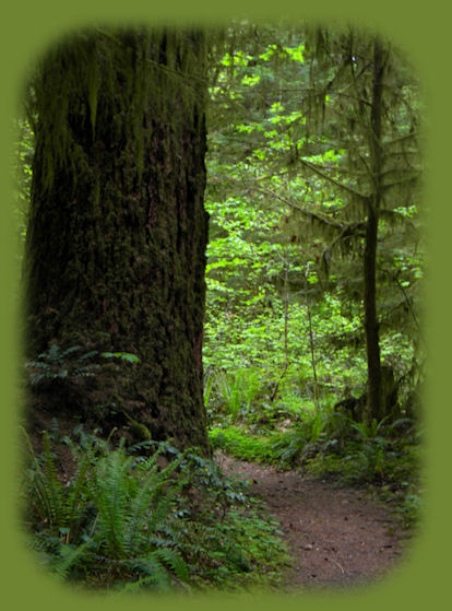
The North Umpqua River Hiking TrailThe hiking trail is divided into segments accessible at different trailheads clearly marked as you drive on the Rogue Umpqua Scenic Byway. The following information gives the names of the hiking trails, the trailheads, and the lengths of the hiking trails: The Tioga segment of the Umpqua River Hiking TrailTioga hiking trail is accessed at Swiftwater Trailhead east of Idlyld, Oregon, east of the Narrows on the Umpqua River on the west and at Wright Creek Trailhead on the east. Tioga hiking trail is 15.7 miles. This hiking trail is rated difficult by the forest service due to length and steep terrain. The trail is the lowest in elevation, providing year round recreation. The trail winds through Old Growth Forest of Douglas fir, Hemlock and Sugar Pine with trees over six feet in diameter. Day-hikers on the Tioga segment of the Umpqua River Hiking TrailTraveling west to east: The first 0.25 mile is accessible to the physically challenged, providing easy access to Deadline Falls. Hike through forested fern groves to Fern Creek Falls a mere 1.75 miles from Swiftwater Trailhead. Hike a few more miles to Bob Butte and the rock outcrop meadow, recommended as the place to turn around before hiking back to Swiftwater Trailhead. For those who want more than a day hike on the Tioga SegmentThe trail drops down from Bob Butte and continues for many miles, a gentle meander river side on the wild and scenic Umpqua River. Primitive, "no-trace" camping Only, is allowed alongside the trail. The Mott Segment of the Umpqua River Hiking TrailThe Mott Segment is accessed at Wright Creek Trailhead near Bogus Creek Campground on the west and Mott trailhead at historic Mott Bridge near Island Campground just east of Steamboat Creek. Unlike any of the other segments, the Mott trailhead has running water. The trail is 5.5 miles long and rated moderate by the USFS. It passes through Old Growth Forest on the western segment. The trail follows the Umpqua River with short trails leading to the river's edge where you can try fly-fishing and enjoy, photograph, beautiful scenery. The McDonald Trail in the Mott Segment of the Umpqua River Hiking Trail
The McDonald Trailhead is found east of Wright Creek. It's 4 miles long. It passes through middle-aged and Old Growth Forests and an old homestead after climbing several steep switchbacks. Wildflowers abound in spring. Mott Segment of the Umpqua River Hiking Trail - the Riverview TrailRiverview trail is part of the old Umpqua Highway built in 1926. The trail is 6 miles long and offers an opportunity to make a loop when hiking or mountain biking and combined with the Mott Segment of the North Umpqua Trail. Access to the trail is either at Bogus Creek Campground on the west or just off Hwy 138 on Forest Road 38 on the east end. The Panther Segment of the Umpqua River Hiking TrailThe Panther segment is accessed at Mott Trailhead on the west and Panther Trailhead across the river from Apple Creek Campground on the east. Panther Trailhead is at an elevation of 1320'. It's 5 miles long and has a moderate rating. The Panther segment is an excellent year round trail for hiking, mountain biking and horseback riding. The trail passes by alder-covered gravel bars then climbs up and away from the river on rocky bluffs. The Calf Segment of the Umpqua River Hiking TrailCalf segment of the Umpqua River Trail is accessed at Panther Trailhead on the west and Calf Trailhead on the east. Calf Trailhead is at an elevation of 1440'. The trail is 3.7 miles long and has a moderate rating. It stays close to the river, allowing those hiking to hear the rapids. The Apple Fire of 2002 burned through here. Contact the North Umpqua Ranger Station about trail conditions before attempting this hike. The Calf Trailhead is a little east of Horsehoe Bend Campground. The Marsters Segment of the Umpqua River Hiking TrailThe Marsters segment is accessed at Calf Trailhead on the west and Marsters Trailhead on the east. The Marsters can be found at Marsters Bridge, when the road moves from one side of the river to the other. Marsters trailhead is at elevation 1580'. The trail is 3.6 miles long and is rated moderate. The trail winds through moss covered bluffs, fern covered hillsides and lush forests. At one point it rises above an old growth Douglas fir stand with several trees of diameters from 5 to 7 feet: giants over 800 years old. Weeping Rocks Spawning Beds: Turn off Hwy 138 on Forest Road 4770 just after Marsters Bridge; cross the forest service bridge, pull off the road and look in the water. From September to November adult Chinook salmon return from the Pacific Ocean to spawn at this site. Marsters Trailhead is east of Eagle Rock Campground. The Jessie Wright SegmentThis segment is named after Jessie Wright, who, along with her husband, Perry, once homesteaded in the area. The Jessie Wright segment is accessed at Marsters Trailhead on the west and Soda Springs Trailhead on the east. Soda Springs Trailhead is at an elevation of 1800'. The trail is 4.1 miles long and is rated moderate. The trail follows an old roadbed into Dark Canyon, through a forest of Doug fir and big leaf Maple and below the volcanic remnants of Eagle Rock and Ol' Pa, both of which can also be viewed from Hwy 138. Several side trails intersect with Jessie Wright Segment
Illahee Flats Trail - 1 mile long - leads to a meadow used in the past by the native peoples of the area and also as a Forest Service Guard Station. Now it's popularly used by equestrians. The Boulder Creek and Bradley Trails give a loop through Boulder Creek Wilderness. Both trails are closed to mountain bikes. Deer Leap SegmentThe Deer Leap Segment is accessed at Soda Springs Trailhead on the west and Toketee Lake Trailhead on the east. Toketee trailhead is at an elevation of 2426'. Hiking west to east, the trail is rated moderate. Hiking east to west, it's rated difficult. Deer Leap segment is named after a volcanic plus that rises 1500' above the river; this trail segment follows high along the canyon rim. Look for a great view from an open bluff rising 500 feet above the North Umpqua River. Toketee Lake Trailhead is not far at all from Toketee Lake Campground. Stop to fish in the lake if you like. Side Trips from Deer Leap Segment
Medicine Creek Indian Pictographs 1.0 mile up Road 4775. Please respect this cultural heritage site. Near Toketee Lake is Toketee Falls, requiring a separate hike. The hike to Toketee Waterfall is only 0.8 mile round trip, but you must also get to the trailhead for Toketee Falls from the Toketee Lake Trailhead for the North Umpqua Trail. I heartily recommend hiking to Toketee Waterfall. Hot Springs SegmentThe Umpqua Hot Springs segment is accessed at Toketee Lake trailhead on the west and the Hot Springs Trailhead on the east. The Hot Springs Trailhead is at 2720' elevation. The trail is 3.5 miles long and rated moderate. It crosses the Umpqua River 3 times. The Dread and Terror SegmentSurprise and Columnar Waterfalls just east of Umpqua Hot Springs. Columnar Waterfalls are so named because of the beautiful rock formations, which you'll find all over the Umpqua River Watershed. Not the least being Toketee Waterfalls. Beautiful, tempestuous Lemolo Waterfalls several miles further east. Lemolo SegmentThe Lemolo segment is accessed at White Mule Trailhead on the west and Kelsey Valley Trailhead on the east. Kelsay Valley Trailhead is at an elevation of 4280'. The Lemolo segment is 6.3 miles long and rated moderate. It travels along the lower slopes of Bunker Hill though mixed conifer forests of Doug Fir, Lodgepole and Ponderosa Pine. There are 4 campgrounds on Lemolo Lake, to the south of the trail: Poole Creek, Bunker Hill, Inlet and East Lemolo Campgrounds. A slight deviation of 0.5 mile on Road 700 as it crosses the trail will bring you to Crystal Springs and a dispersed campsite. The moss covered springs demonstrate how well the volcanic rock Cascade Mountains stores water. There is a campground near Kelsay Valley Trailhead. ... and finally ... the Maidu SegmentThe Maidu segment is accessed on the west at Kelsay Valley Trailhead and on the east at Digit Point Trailhead. Digit Point Trailhead is accessed by a hiking 4.75 miles to Miller Lake in the Winema National Forest. The elevation of Digit Point Trailhead is 5630'. The Maidu Segment is 9 miles long and rated difficult. The first mile follows the river. At 2.7 miles, near the Tolo Mountain Trail (#1477) you enter the Mt Thielsen Wilderness Area. This segment is closed to mountain biking. As you climb toward Maidu Lake, you will hike through deep deposits of pumice, reminder of Mt Mazama's eruption 7,700 years ago. Lake Lucile and Maidu Lake on the Maidu segment are stocked with fingerling trout. Lake Lucile covers 15 acres and averages 15 feet deep, Maidu Lake covers 20 acres and averages a depth of 12 feet. Lake Maidu is the source of the Umpqua River. Connect with the Pacific Crest Trail at this end of the Umpqua River Trail. Digit Point Campground is on Miller Lake. It is 13 miles from the campground to Chemult, Oregon. | |||
|
Except for my editorial comments, the information compiled in this description of hiking trails on the Umpqua River came from the combined resources of the Umpqua National Forest, the Roseburg District of the BLM and the City of Roseburg. For myself, I have wanted to hike along these trails for so long, but no one has ever wanted to do it with me. I am going to be doing some of the shorter trails by myself this year, but I must say, Brad was finally interested when I said, "I don't know why you don't want to do these hikes," and told him about the Doug Firs 800 years old. He was impressed, and Finally enthusiastic! - gm | |||
|
If you have any questions about any of the individual trails contact: Tioga Segment: Roseburg District BLM (first 11 miles of the trail): 541.440.4930 North Umpqua Ranger Station (4.7 miles of the trail): 541.496.3532. Mott through Marsters Segments: North Umpqua Ranger District: 541.496.3532. Jessie Wright through Maidu Segments: Diamond Lake Ranger District: 541-498-2531. | |||
| |||
| |||
| |||