beautiful toketee waterfall on the umpqua river with hiking trail.  

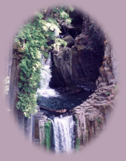
Beautiful Toketee Waterfall on the Umpqua Waterfall Tour

Forward ~ Scenery on the north Umpqua River
on the Umpqua Scenic Byway, Hwy 138.

Back ~ Travel Map for the Umpqua Scenic Byway
Hwy 138, and the Willamette Pass, Hwy 58.

USFS: Umpqua National Forest.

Brad and I happily offer the North Umpqua Waterfall Tour: the Umpqua Scenic Byway, wild and scenic rivers: waterfalls, hiking trails, Cascade Mountains, Diamond Lake, Crater Lake: Scenery and Map. Or try the Diverse Loop Tour including Crater Lake, the Rogue River Gorge, waterfalls, hiking trails, the Cascade Mountains and more: Directions, Map and Scenery.

Travel Directions to the South Umpqua River,
waterfalls & campgrounds.

Poison Oak can be a problem at these elevations.

The Umpqua Waterfall Tour on the Rogue Umpqua Scenic Byway
in the Umpqua National Forest of Oregon.

Our Getaways offer written Directions, Maps and suggested scenery, spanning Oregon and northern California; places Brad and I have visited and loved. These getaways offer simplicity, yet beauty in scenery, waterfalls, hiking trails, campgrounds, mountains, hot springs, mountain lakes, equestrian trails, mountain biking trails, wild and scenic rivers, scenic byways, Crater Lake National Park, national monuments & more.

Protect our National Forests and Wilderness Areas. Leave NO Trace!
Be sure to check out road and fire conditions at the Ranger Station when planning
and before traveling, hiking or camping in the forest.

Hwy 138 travels east - west from the Oregon coast to Hwy 97 in central Oregon. The portion east of Glide traveling through the Cascade Mountains is the Umpqua Scenic Byway. The highway connects with Diamond Lake and then the north entrance to Crater Lake. My favorite route encompasses the Umpqua River, Crater Lake, Diamond Lake and the waterfalls. ~ gm

Begin at Crater Lake National Park

Begin at any point of the tour, but for our purposes, I will choose Crater Lake, as the starting point. Depending on the time of year, you would have to begin either at the north or south entrance. The north entrance, which begins off hwy 138 is the obvious choice, but it's only open for a few months during the summer. I will give both options here: Exiting the park at the north entrance, turn left at the stop sign, the road sign on 138, or the Umpqua Scenic Byway, will give directions to Roseburg. That's the way you want to go. If the north entrance is not open, exit at the south entrance, which intersects with Hwy 62, or the Crater Lake Hwy. Head west on 62, it will intersect with hwy 230, the Rogue Umpqua Scenic Byway, at that juncture, turn north on 230. If you turn south, you will remain on hwy 62, which offers it's own charms, but I'm giving directions for Umpqua Scenic Byway here. ;o)

If you choose the south entrance to Crater Lake:

If you choose to take the route that originates at the south entrance to Crater Lake National Park, there's a pretty, yet short, hike to National Creek Waterfalls. (See National Creek Waterfall in the Scenic Vistas on the Diverse Loop Tour.) The sign appears on the right not long after the turn north. Access to the trailhead is but a short drive on a FS road. The hike is an approximate mile round trip. Regardless which route you choose, both are beautiful, each offering unique vistas and charm.

Travel Hwy 230, the beginning jog of the Rogue Umpqua Scenic Byway

Hwy 230 connects with Hwy 138 a little to the west of the north entrance to, Crater Lake. Once you've connected with Hwy 138, you'll see the turn off for Diamond Lake. Stop here for a time if you choose -- perhaps just a drive around the lake, and amazing vistas of Mt Thielsen.

Back to Hwy 138 - travel roughly west and you'll see the signs for a succession of waterfalls. Clearwater Falls is the first. It's just a brief walk from the car, take a look and it's easy to see how the fall got its name. Hwy 138 is marked with the signs to other waterfalls: Whitehorse Falls, Watson Waterfalls and beautiful Toketee, the crown of the river is next. The Umpqua River comes into view only after the sign for Toketee Waterfalls. If you can walk, and have no problem with stairs, be sure to stop at Toketee; from the photo displayed above it should be easy to see why I make this recommendation. Toketee is my favorite, otherwise, it's very difficult to discriminate between the others. Watson Waterfall is grand, the height, the amount of water falling, the breadth of the canyon walls - reminiscent of an amphitheatre. If walking is a problem, Whitehorse and Clearwater Waterfalls are easily viewed. Whitehorse offers a viewing platform from the parking lot. Susan Creek is lovely and the trail is wheelchair accessible. Fall Creek Waterfalls is to be recommended, not the least because of the waterfall, which is quite beautiful, but also because of the trail. Deadline Waterfalls, a class 5 rapid, is the last waterfall, heading west. It's just east of Swiftwater State Park at Idlelyd, Oregon. Continue heading west & you'll arrive at the town of Glide where the Little River crashes headlong into the North Umpqua. An amazing phenomenom in itself.

The Little River, tributary to the North Umpqua River

The Little River offers it's own beauty. Drive through farmlands, alongside the river. Stop at the trailhead for Deer Creek, drive further if you want to see Grotto, Yakso, and Hemlock Waterfalls. Deer Creek is accessible on the county road, which follows the river. The roads for the last three falls are forest service and gravel. The forest service rates the trails for the last three falls as more difficult. If you're interested in viewing the falls, please see Scenery in the Umpqua Watershed.

Enjoy the river, enjoy the waterfalls.

As I stated earlier, Hwy 138 extends from Hwy 97 to the Reedsport on the Oregon Coast. Perhaps you want to go the beach. :o) Upon arriving in Roseburg, get on I - 5 heading north. Exit at Sutherlin, and follow the signs to the beach. At this point the Umpqua River has settled into a gentle meander, somnolent in summer, and little more than that in winter. There are nice waysides to stop and relax before continuing your drive. Once you arrive in Reedsport, you can head either north of south. South will eventually bring you to many of the sites pictured in the southern Oregon pages of this website, as well as, the Oregon Redwoods on the Chetco River, and further south, the California Redwoods. Scenery on the Oregon and northern California coasts.

The South Umpqua River

The South Umpqua River offers beauty and charm all it's own. Waterfalls, a great swimming hole at South Umpqua Waterfall, the Boulder Creek Wilderness area and more.

Travel the south fork of the Umpqua River.

wild flowers blooming on one of many hiking trails in oregon.  enjoy hiking the north umpqua trail in the umpqua national forest; camping in the umpqua national forest and hiking trails to waterfalls in the wild and scenic umpqua river watershed: brice creek waterfalls, moon waterfalls, pinard waterfalls, spirit falls; hiking trails off the Rogue Umpqua Scenic byway on the wild and scenic umpqua river in the umpqua national forest: toketee waterfalls, watson falls hiking trails, fall creek falls, susan creek day use area, susan creek hiking trails, susan creek campgrounds off the rogue umpqua scenic byway, toketee campgrounds off the rogue umpqua scenic byway, lemolo campgrounds off the rogue umpqua scenic byway, diamond lake campgrounds, boulder creek campgrounds, canyon creek campgrounds, umpqua national forest campgrounds, clearwater falls campgroud, island campgrounds, lake in the woods campgrounds, bogus creek campgrounds, apple creek campground, steamboat falls campground, williams creek and eagle rock campgrounds, horseshoe bend and canton creek campgrounds, devil's campground on cow creek, cedar creek campground on brice creek, rujada campground on layng creek, whitehorse falls and clearwater falls campgrounds, susan creek waterfalls, north umpqua river, south umpqua river, umpqua river hiking trails accessed off the rogue umpqua scenic byway, forest service campgrounds, blm campgrounds, cavitt creek recreation area, deadline falls, steelhead in the umpqua river, angling, hiking trails to lemolo waterfalls, clearwater waterfalls, whitehorse waterfalls, clearwater river, toketee lake, umpqua hot springs, steamboat creek waterfalls, warm springs waterfalls, lemolo lake; hiking trails on the little river in the umpqua river watershed in the umpqua national forest: wolf creek waterfalls, grotto falls, hemlock waterfalls, hemlock lake, cavitt creek waterfalls, recreation area, shadow waterfalls, yakso waterfalls; hiking trails on the south umpqua river watershed: south umpqua waterfalls, campbell waterfalls, hiking trails in theboulder creek wilderness area, hiking trails in the mt thielsen rogue umpqua divide wilderness area, cathedral waterfalls off the south umpqua river; hiking trails in the row river watershed: moon, spirit and pinard waterfalls.

Wildflowers blooming along the hiking trail at Big Obsidian Flow, just one of the many hiking trails in Oregon.

Plan your visit to the many waterfalls and hiking trails in the Umpqua National Forest. Want to learn more about the campgrounds on the North Umpqua River and others in the Umpqua River watershed? Brad and I call the route and hiking trails we love, driving along the Rogue Umpqua Scenic Byway, the North Umpqua Waterfall Tour: Directions: and Map.

Poison Oak can be a problem at these elevations.

Campgrounds in the Row River Watershed

Brice Creek: Cedar Creek Campground, Lund Campground and Hobo Campground.

Sharps Creek: Mineral Camp Campground. Sharps Creek Recreation Area, not associated with the Umpqua National Forest, can be found on Sharps Creek also. It has a great swimming hole.

Layng Creek: Rujada Campground. For more information on camping in the Row River watershed ...

 
Camping in the Umpqua National Forest & those areas managed by the BLM

Directions to campgrounds in the Diamond Lake District of the Umpqua National Forest. Directions to campgrounds in the North Umpqua River district. The campgrounds for both districts are off the Rogue Umpqua Scenic Byway, many are on the wild and scenic Umpqua River. All fall between the north entrance to Crater Lake National Park and I-5 at Roseburg, Oregon. Boulder Flat is the last one in the North Umpqua district. After that you're in the Diamond Lake District. Directions to campgrounds in the Little River watershed of the North Umpqua River. Directions for camping facilities in the Row River watershed of the Umpqua River. Directions to campgrounds on the south Umpqua River also in the Umpqua River watershed.

 
Hiking Trails in the Umpqua River watershed
in the Umpqua National Forest:

Directions for hiking trails to waterfalls and other points of interest in the Row River Watershed of the wild and scenic Umpqua River in the Umpqua National Forest. As well as Directions for the Umpqua River Trail - 12 hiking trails riverside. Directions for hiking trails to the many waterfalls on the wild and scenic Umpqua River off the Rogue Umpqua Scenic Byway. Directions for hiking trails in the south Umpqua watershed. Directions for hiking trails in the Little River watershed. Most within the magnificent Umpqua National Forest.

Enjoy the North Umpqua Waterfalls Tour on the Rogue Umpqua Scenic Byway:

Can include Crater Lake National Park: Introduction.

Travel Directions, Map and Scenery ~ can include Crater Lake National Park: Introduction. Experience: splendid scenery, hiking trails for intrepid hikers and those with less enthusiam. Enjoy the magnificent the wild and scenic Umpqua River, Umpqua hot springs near Toketee Campground, rafting on the rapids, hiking the beautiful trail along the Umpqua gorge to magnificent Toketee Waterfalls, my favorite, and the favorite of anyone I've ever spoken to. Hike through a forest garden of dense wild rhododendrons at Warm Spring Waterfalls. Hike the trails to experience the wonder of tumultuous Watson Falls. Don't forget Lemolo Waterfalls and Lemolo Lake. And when you arrive at the north entrance partake the splendor of Crater Lake - Enjoy beauty.

Enjoy the Diverse Loop Tour on the Rogue Umpqua Scenic Byway & Crater Lake Hwy

Includes Crater Lake National Park: Introduction.

Travel Directions, Map and Scenery. Experience: splendid scenery, hiking trails for intrepid hikers and those with less enthusiam, experience the majestic Rogue River Gorge at Union Creek and the Natural Bridge, waterfalls, the Rogue River Hiking Trail, hiking trails to Muir Creek Waterfalls and National Creek Waterfalls all in the Rogue - Siskiyou National Forest. Enjoy hiking trails to Mill Creek Waterfalls, Barr Creek Waterfalls and Pearsoney Waterfalls in Prospect, Oregon. Or just stand on the historic Prospect bridge and enjoy the panorama of the Avenue of Giant Boulders. Hike down to the water's edge if you've a mind to.

Combine the Umpqua Waterfalls and the Diverse Loop Tours

Traveling Oregon on the Rogue Umpqua Scenic Byway and the Crater Lake Hwy: Directions.

Travel Oregon and southern California while staying at Gathering Light ... a retreat
located in southern Oregon near Crater Lake National Park.

The Unique and unusual at Gathering Light Nature Retreat located in southern Oregon near Crater Lake National Park.


Wild Iris blooming along the river at Gathering Light ... a retreat in south central Oregon not far from Crater Lake National Park, albeit at a lower elevation.

Traveling the Rogue Umpqua Scenic Byway to the retreat: Travel Directions, Map & Scenery.

Directions to & Day Trips of about 100 miles from the retreat.

Little Known Scenic Places near Crater Lake & Gathering Light: Travel Directions, Map & Scenery.

Contact Brad at Gathering Light Nature Retreat.

Website Directory for the travel pages      Home Page

Page Listings to the travel pages

Copyright 1999 - 2012. All rights reserved.