lemolo waterfalls on the wild and scenic umpqua river, off the rogue umpqua divide, on the rogue umpqua scenic byway in the cascade mountains of oregon; enjoy camping in the umpqua national forest and hiking trails to waterfalls in the wild and scenic umpqua river watershedt: brice creek waterfalls, moon waterfalls, pinard waterfalls, spirit falls; hiking trails off the Rogue Umpqua Scenic byway on the wild and scenic umpqua river in the umpqua national forest: toketee waterfalls, watson falls hiking trails, fall creek falls, susan creek day use area, susan creek hiking trails, susan creek campgrounds off the rogue umpqua scenic byway, toketee campgrounds off the rogue umpqua scenic byway, lemolo campgrounds off the rogue umpqua scenic byway, diamond lake campgrounds, boulder creek campgrounds, canyon creek campgrounds, umpqua national forest campgrounds, clearwater falls campgroud, island campgrounds, lake in the woods campgrounds, bogus creek campgrounds, apple creek campground, steamboat falls campground, williams creek and eagle rock campgrounds, horseshoe bend and canton creek campgrounds, devil's campground on cow creek, cedar creek campground on brice creek, rujada campground on layng creek, whitehorse falls and clearwater falls campgrounds, susan creek waterfalls, north umpqua river, medicine creek native pictorgraphs, indian pictographs, south umpqua river, umpqua river hiking trails accessed off the rogue umpqua scenic byway, forest service campgrounds, blm campgrounds, cavitt creek recreation area, deadline falls, steelhead in the umpqua river, angling, hiking trails to lemolo waterfalls, clearwater waterfalls, whitehorse waterfalls, clearwater river, toketee lake, umpqua hot springs, steamboat creek waterfalls, warm springs waterfalls, lemolo lake; hiking trails on the little river in the umpqua river watershed in the umpqua national forest: wolf creek waterfalls, grotto falls, hemlock waterfalls, hemlock lake, cavitt creek waterfalls, recreation area, shadow waterfalls, yakso waterfalls; hiking trails on the south umpqua river watershed: south umpqua waterfalls, campbell waterfalls, hiking trails in the boulder creek wilderness area, hiking trails in the mt thielsen rogue umpqua divide wilderness area, old growth forests, cathedral waterfalls off the south umpqua river; hiking trails in the row river watershed: moon, spirit and pinard waterfalls.

Hiking Trails
Lemolo Waterfalls
on the wild and scenic
Umpqua River

Lemolo Waterfalls, and the hiking trail to it, is remarkable. The word "lemolo" in Chinook jargon means wild, untamed, and just as toketee, meaning pretty, graceful, comes to life when you see that fall, so does this. The hike is downhill all the way, and conversely, uphill on the return. As is stated in the Umpqua National Forest website, "A steep climb back up.". Hence the rating of difficult. I must say, the walk along the Umpqua when you get down into the canyon and the views of Lemolo Falls are worth every step. For more information: USFS: Umpqua National Forest or call the Toketee Ranger Station: 541-498-2531.

Protect our National Forests and Wilderness Areas. Leave NO Trace!

Directions for the hiking trail to Lemolo Waterfalls
in the Umpqua National Forest

The Best View

Before I begin with the directions, I have a caveat. There seems to be some confusion as to the name of FS 2610 on the Umpqua National Forest Website. It's called the Lemolo Lake Road, and I think that's right, since it takes you right by the lake. However, the directions given on USFS site for Lemolo Falls calls it Birds Point Road. On the page for Warm Springs Waterfalls, Birds Point Road is 2610-600. We're going back this summer. I will check it all out then, but for now I give you this caveat. Either way, as long as you're on FS road 2610, you'll know you're on the right road.

Turn north off the Rogue Umpqua Scenc Byway, Hwy 138, onto FS Road 2610. Drive 4.2 miles to FS Road 3401, Thorn Prairie Road. Go about .5 mile, turn right on FS Road 3401-800. Continue 1.75 miles, turn right at Road 3401-840. The trail is at the end of the road: .25 mile. These smaller roads are not the best, believe me. Not bad, just not good.

The trail is 1.7 mile. The brochure Thundering Waters distributed by the Umpqua National Forest, the Roseburg BLM and the city of Roseberg, rate this trail most difficult. As I stated above, it's rated difficult on the website. :-) All you need to remember is that it's a steady uphill climb out of the canyon.

The view from the top looking down

Turn north off of the Rogue Umpqua Scenic Byway onto 2610, as described above. Drive 5.2 miles, crossing the dam to the rok in the road. Take the fork to the left, Road 2610-600. Proceed .5 mile, turn left across the wooden bridge and park at the trailhead. It's 1.5 miles to the waterfall, walking along the North Umpqua River Trail. This is a beautiful walk. Even if you never make it to the waterfall. :-)

Nearby Attractions: Lemolo Lake Resort, Poole Creek Campground, Warm Springs Falls.

Protect our National Forests and Wilderness Areas. Leave NO Trace!

To make sure we do it all, Check the 7 Principles of "Leave NO Trace!".

Forward ~ Lemolo Lake: Resort and Campgrounds.

Back ~ Warm Springs Waterfalls shaped by
columnar basalt.

USFS: Umpqua National Forest in Oregon.

Plan your visit to the many waterfalls and hiking trails in the Umpqua National Forest. Want to learn more about the campgrounds on the North Umpqua River and others in the Umpqua River watershed?

Poison Oak can be a problem at these elevations. Want to see a picture?

Hiking the Tioga segment of the north Umpqua
River Hiking Trail pictured to the right.

umpqua river viewed from the rogue umpqua divide, the rogue umpqua scenic byway in the cascade mountains; enjoy camping in the umpqua national forest and hiking trails to waterfalls in the wild and scenic umpqua river watershedt: brice creek waterfalls, moon waterfalls, pinard waterfalls, spirit falls; hiking trails off the Rogue Umpqua Scenic byway on the wild and scenic umpqua river in the umpqua national forest: toketee waterfalls, watson falls hiking trails, fall creek falls, susan creek day use area, susan creek hiking trails, susan creek campgrounds off the rogue umpqua scenic byway, toketee campgrounds off the rogue umpqua scenic byway, lemolo campgrounds off the rogue umpqua scenic byway, diamond lake campgrounds, boulder creek campgrounds, canyon creek campgrounds, umpqua national forest campgrounds, clearwater falls campgroud, island campgrounds, lake in the woods campgrounds, bogus creek campgrounds, apple creek campground, steamboat falls campground, williams creek and eagle rock campgrounds, horseshoe bend and canton creek campgrounds, devil's campground on cow creek, cedar creek campground on brice creek, rujada campground on layng creek, whitehorse falls and clearwater falls campgrounds, susan creek waterfalls, north umpqua river, medicine creek native pictorgraphs, indian pictographs, south umpqua river, umpqua river hiking trails accessed off the rogue umpqua scenic byway, forest service campgrounds, blm campgrounds, cavitt creek recreation area, deadline falls, steelhead in the umpqua river, angling, hiking trails to lemolo waterfalls, clearwater waterfalls, whitehorse waterfalls, clearwater river, toketee lake, umpqua hot springs, steamboat creek waterfalls, warm springs waterfalls, lemolo lake; hiking trails on the little river in the umpqua river watershed in the umpqua national forest: wolf creek waterfalls, grotto falls, hemlock waterfalls, hemlock lake, cavitt creek waterfalls, recreation area, shadow waterfalls, yakso waterfalls; hiking trails on the south umpqua river watershed: south umpqua waterfalls, campbell waterfalls, hiking trails in the boulder creek wilderness area, hiking trails in the mt thielsen rogue umpqua divide wilderness area, old growth forests, cathedral waterfalls off the south umpqua river; hiking trails in the row river watershed: moon, spirit and pinard waterfalls.

 
Camping in the Umpqua National Forest & those
areas managed by the Roseburg BLM

Directions to campgrounds in the Diamond Lake District of the Umpqua National Forest. Directions to campgrounds in the North Umpqua River district. The campgrounds for both districts are off the Rogue Umpqua Scenic Byway, many are on the wild and scenic Umpqua River. All fall between the north entrance to Crater Lake National Park and I-5 at Roseburg, Oregon. Boulder Flat is the last one in the North Umpqua district. After that you're in the Diamond Lake District. Directions to campgrounds in the Little River watershed of the North Umpqua River. Directions to camping facilities in the Row River watershed of the Umpqua River. Directions to campgrounds on the south Umpqua River also in the Umpqua River watershed.

 
Hiking Trails in the Umpqua River watershed in the Umpqua National Forest

Directions for hiking trails to waterfalls and other points of interest in the Row River Watershed of the wild and scenic Umpqua River in the Umpqua National Forest. As well as Directions for the Umpqua River Trail - 12 hiking trails riverside. Directions for hiking trails to the many waterfalls on the wild and scenic Umpqua River off the Rogue Umpqua Scenic Byway. Directions for hiking trails in the south Umpqua watershed. Directions for hiking trails in the Little River watershed. All within the magnificent Umpqua National Forest.

Twin Lakes in the Umpqua National Forest

Twin Lakes, being so comprehensive in what the hike has to offer: graceful lakes, mountain cliff and grottoes, wildflowers, expansive views of mountains, old growth Doug Firs, campsites, handcrafted picnic tables, a dock and camping shelters, merits its own section: Directions, description and facilities available.

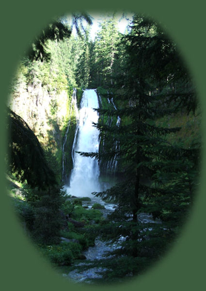
Enjoy the North Umpqua Waterfalls Tour on the Rogue Umpqua Scenic Byway

Can include Crater Lake National Park: Introduction.

Travel Directions, Map and Scenery ~ can include Crater Lake National Park: Introduction. Experience: splendid scenery, hiking trails for intrepid hikers and those with less enthusiam. Enjoy the magnificent the wild and scenic Umpqua River, the diversity of the Umpqua National forest, Umpqua hot springs near Toketee Campground, rafting on the rapids, hiking the beautiful trail along the Umpqua gorge to magnificent Toketee Waterfalls, my favorite, and the favorite of anyone I've ever spoken to. Hike through a forest garden of dense wild rhododendrons at Warm Spring Waterfalls. Hike the trails to experience the wonder of tumultuous Watson Falls. Don't forget Lemolo Waterfalls and Lemolo Lake. And when you arrive at the north entrance partake the splendor of Crater Lake - Enjoy beauty.

Enjoy the Diverse Loop Tour on the Rogue Umpqua National
Scenic Byway and the Crater Lake Hwy

Includes Crater Lake National Park: Introduction.

Travel Directions, Map and Scenery. Experience: splendid scenery, hiking trails for intrepid hikers and those with less enthusiam, experience the majestic Rogue River Gorge at Union Creek and the Natural Bridge, waterfalls, the Rogue River Hiking Trail, hiking trails to Muir Creek Waterfalls and National Creek Waterfalls all in the Rogue - Siskiyou National Forest. Enjoy hiking trails to Mill Creek Waterfalls, Barr Creek Waterfalls and Pearsoney Waterfalls in Prospect, Oregon. Or just stand on the historic Prospect bridge and enjoy the panorama of the Avenue of Giant Boulders. Hike down to the water's edge if you've a mind to.

Combine the Umpqua Waterfalls and the Diverse Loop Tours

Traveling Oregon on the Rogue Umpqua Scenic Byway and the Crater Lake Hwy: Directions.

Travel Oregon and northern California while staying at Gathering Light ... a retreat
located in southern Oregon near Crater Lake National Park.

Travel on the Rogue Umpqua Scenic Byway to Gathering Light ... a retreat: Directions Map & Scenery. Experience the columnar basalt of Toketee Waterfalls, tumultuous Watson Falls ... the wild & scenic Umpqua River in the Umpqua National Forest. Arriving at the north entrance of Crater Lake National Park, enjoy Crater Lake too.

Travel Directions to & Day Trips of about 100 miles from the retreat.

Little known Scenic Places to explore nature: hiking, with and without, trails, wetlands, national wildlife refuges, mountains, wilderness areas, river gorges & more near Crater Lake National Park & the retreat: Travel Directions, Map & Scenery.

Website Directory      Page Listings       Home Page

Contact Brad at Gathering Light ... a retreat.

stay in the cabins on the river in the forest at gathering light retreat located in southern oregon near crater lake national park and travel oregon and experience volcanoes, geology, hiking trails, oregon geology, rogue siskiyou national forest, wild and scenic rogue river, wild and scenic umpqua river, rogue gorge at union creek, oregon, national rogue river hiking trail, rogue national forest, national forests, wilderness areas, national wildlife refuges, wetlands, klamath basin, prospect, oregon, mill creek waterfalls on the rogue river, barr creek waterfalls on the rogue river, avenue of giant boulders on the rogue river, hiking trails to mill creek waterfalls, hiking trails to barr creek waterfalls on the rogue river, hiking trails to national creek waterfalls in the rogue siskiyou national forest, hiking trails along the rogue river, hiking trails to the natural bridge, hiking trails at crater lake national park, crater lake national park, hiking trails on the wild and scenic rogue river, hiking trails to national creek waterfalls, national wildlife refuges, wetlands, rabbit ears, the cascade mountains, the old cascade mountains, mt thielsen, hiking trails at crater lake, crater lake national park.

Walking in the forest (pictured above) at Gathering Light ... a retreat. Rustic simplicity, a place to "Just Be", Gathering Light is nestled on the banks of the river, surrounded by the Fremont Winema National Forest of southern Oregon and not far from Crater Lake National Park.