|
Hiking Trails | |
| |
|
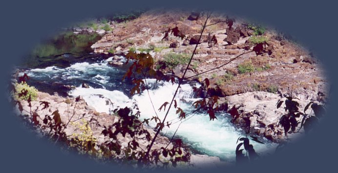
The wild and scenic Umpqua River at the narrows. The Umpqua Waterfall Tour,
| |
|
Forward ~ Map of the extended Umpqua Waterfall Tour. Back ~ The Umpqua Waterfall Tour Map. USFS: Umpqua National Forest Combine the North Umpqua Waterfall and Diverse Loop Tours: sightseeing, Crater Lake, hiking, mountain biking and equestrian trails, waterfalls, mountains, wild and scenic rivers, the Rogue Umpqua Scenic Byway ... Directions, Map and Scenery: The Diverse Loop Tour and Umpqua Waterfall Tour. Hiking the trail to Watson Falls in the wild and scenic Umpqua River watershed, pictured to the right. |
|
|
The Umpqua River Hiking Trail. Hwy 138 boasts a succession of waterfalls, all marked by signs. Stop at Glide where the Little River collides head on with the North Umpqua River and see an amazing geological phenomenom. Check out the waysides. It's possible to hike much of the river on the southern bank. The trail is segmented and can be accessed at any of the bridges. Check out the waysides, any and all offer their own individual charm; the narrows pictured above can be viewed at a Douglas County wayside. As can be imagined, the view is quite spectacular; even more so when the river is high. The Umpqua River Waterfall Hiking Trails: Susan Creek Waterfall, around the 28th mile marker, is the first waterfall heading west on the Umpqua Scenic Byway. The trail is improved and suitable for wheelchairs. The area offers a quite nice forest service camp and day use area. The trailhead for Fall Creek, one of my favorites on the North Umpqua is next, around the 32 mile marker. This trail is quite beautiful, and would be quite enjoyable if the waterfall were not at the end. Steamboat Waterfall is accessed off Steamboat Creek, just before Dry Creek. Dry Creek offers a small grocery store and gas. Enjoy the vistas of the river as you drive. Stop in the various pullouts. A beautiful and quite unexpected sight can be found at the Transfer Station of all places. I don't know how many times I drove by this road -- I've examined all the others -- thinking it of no interest because it's the Transfer Station. One time, however, I decided to stop, and was more, much more, than pleasantly surprised. If you decide to stop here, drive past the transfer station, and pull off the road just before the bridge. Walk on the bridge, turn so you're heading west and look down. It is so beautiful. I've talked to people who live in the area, it's not unexpected that they would feel smug having this little gem so close at hand ... Once you've viewed the river from the bridge, walk back to south side, and take in as many scenic sites you think you can manage. Toketee is my favorite of all the waterfalls, and I must say, most people feel this way. So be sure to take time out for this. Camp on the river if that fits into your plans. The USFS offers many nice campgrounds along this route. The campground at Clearwater Falls is quite unimproved, so if you think you might want to stay there, plan ahead. Clearwater is the last waterfall. You'll see a sign from the highway. Stop and see Lemolo and Diamond Lakes if you think you'd like. The next major opportunity, and I mean major, is Crater Lake National Park: Introduction. Lemolo Lake and Diamond Lake on the Rogue Umpqua Scenic Byway, Hwy 138: Pull off the highway and camp at Lemolo Lake, catch the many spectacular views of Mt Thielsen. Camp at Diamond Lake just before the north entrance to Crater Lake ... Crater Lake National Park: Entering Crater Lake National Park at the north entrance. Drive either east or west, the rim drive circles the lake. The lodge is accessed more quickly from the western rim, as also is rim village. The drive on the western rim is shorter than the eastern rim. The Phantom Ship is visible only from the eastern drive. Wizard Island can be viewed from many vistas around the rim, but is certainly more easily seen from the western rim drive. Also, Crater Lake boasts many beautiful hikes, so take your time. See as much as you can and take advantage of whatever beauty catches your eye. Crater Lake offers camping, as well as, the lodge. The Rogue Umpqua Scenic Byway on Hwy 230: Exit the park at the north entrance where you came in. Turn left on Hwy 138. Quite soon you'll see the sign for Medford, Hwy 230. There are many beautiful viewpoints. The first that truly stands out is a most spectactular view of Mt Thielsen. The mountain is behind you as you drive, but there's a pullout not too far south on Hwy 230. Travel further south and see Rabbit Ears off to your right. A little further yet, and the sign for National Creek Waterfall appears. The fall is a few miles drive on a FS road; then an approximate ½ mile hike. The first view of the Rogue River from the road is no more than 3 or 4 miles further south on 230. Stop to view the pretty cascade. Brad and I once wandered around the forest in the vicinity of Rabbit Ears. We had a spectacular view of the Rogue way down below. If you decide to attempt this, walk through the forest to the edge of the bluff and look down. Be careful. The drop off is quite substanital; there are no markers and no fence. If you wait for the cascade, it will be on your left. Cross a bridge and the Rogue River will be on your right. Not long after, see the sign for 62 heading east; at this point, 230 intersects with Hwy 62, traveling south. The Rogue River Gorge at Union Creek: Stay on 62 heading south to see some views of the Rogue River at Union Creek where it forges through a narrow channel of volcanic rock before placidly settling into a peaceful river flow. The Natural Bridge is a lava tube through which the Rogue flows. Exit 62 at Prospect for the loop that will take you along Mill Creek. Prospect, Oregon: Mill Creek, Waterfalls and the historic hotel. Prospect Hotel is a renovated late 1800s hotel. One claim to fame is the several personages from the old west who stayed there. Mill Creek Bridge is just south of Prospect. The Avenue of Giant Boulders is viewable from the bridge, however, one can walk among the boulders. The gorge is accessible from two clearly marked paths. One path originates just north of the bridge where you can find a parking lot across the street and not far from the General Store. From there you can walk south to the stream. If you choose the hike to the north, you will see Pearsoney Waterfall, and come out at the creek below the Avenue of Giant Boulders. Or you can walk to the Avenue of Giant Boulders and Mill Creek Waterfall and Barr Creek Waterfall from a trailhead a little further south of Mill Creek Bridge. The trailhead is clearly marked from the road, offering a small parking lot. The trails are short ~ a walk that is quite well marked. This is Boise Cascade land, but the trails are open to the public. Medford, Oregon: Leaving Mill and Barr Creek Waterfall: turn left and continue heading south until the road connects once again with Hwy 62. Follow 62 into Medford, Oregon, and your tour is complete. Unless ... you want to try something else. Ashland Oregon: You might continue south to Ashland, Oregon a town of unique character, for the Oregon Shakespearean Festival, beautiful Lithia Park, excellent fare, Saturday Market on Ashland Creek, and more. South Umpqua River, Waterfalls and Hiking Trails: Look for the sign for Tiller north of Shady Cove on Crater Lake Hwy, turn on Hwy 227, which will then become Road 1 on the way to Tiller. This route is quite picturesque: driving along Elk Creek, different viewpoints of the Cascade Mountains. At Tiller, the route intersects with the South Umpqua River. Turn right after crossing the bridge onto county road 46. County Road 46 becomes South Umpqua Road 28. Follow the river. Find several waterfalls: Cathedral Waterfall, a seasonal waterfall, Campbell Waterfall, South Umpqua Waterfalls and Deer Lick Waterfall. Watch for Poison Oak! It can be a problem at these elevations. If you want to continue on, the road becomes gravel, but it's well maintained. The gorge is quite spectacular, and if you continue your journey, which means follow the road signs, you'll come out at Copeland Creek, a beautiful tributary of the North Umpqua River, exhibiting the familiar columnar basalt of Toketee and Warm Springs Waterfalls. Follow Copeland Creek downstream and until you come out again on Hwy 138. If you don't want to take this route, just turn around after viewing the waterfalls on the South Umpqua. Unless you have a particular reason for going back to Medford, don't backtrack to Hwy 62, rather just continue west until you reach Canyonville on I - 5. :-) Travel Oregon and northern California while staying at Gathering Light ... a retreat | |
|
Travel the Rogue Umpqua Scenic Byway to the retreat. Enjoy waterfalls, hiking trails, hot springs, the wild & scenic Umpqua & more: Directions, Map & Scenery. Travel Directions to and Day Trips of about 100 miles from the retreat. Scenic Places near the retreat & Crater Lake: Directions, Map & Scenery: the Williamson River Gorge, hiking, wetlands: birding, bald eagles, pelicans, grebes, egrets, Klamath Basin birding trails. Website Directory for the travel pages Home Page |
|
|
Mt McLoughlin looming over Agency Lake, not far from the retreat depicted above and to the right. Contact Brad at Gathering Light ... a retreat. | |