|
Forward ~ Diverse Loop Map. Back ~ Introduction to Ashland, Oregon, home of the Shakespearean Festival. Explore the Diverse Loop Tour, on the Rogue Umpqua Scenic Byway & the Crater Lake Hwy, Oregon 62, including Crater Lake National Park, the Rogue River Gorge in Union Creek, hiking trails, the Cascade Mountains, Prospect Historic Hotel, Prospect Bridge, the Rogue at Woodruff Bridge, Takelma Gorge, the Natural Bridge on the Rogue & more ... Map & Scenery. Directions for hiking trails on the Upper Rogue River, other hiking trails found in the area of Union Creek & Prospect, Oregon. |
|
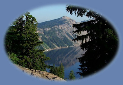
Beautiful Crater Lake ... | |
|
Traveling the Rogue Umpqua Scenic Byway - Crater Lake Hwy | |
|
Our Getaways offer written Directions, Maps and suggested scenery, spanning Oregon and northern California; places Brad and I have visited and loved. These getaways offer simplicity, yet beauty in scenery, waterfalls, hiking trails, campgrounds, mountains, hot springs, mountain lakes, equestrian trails, mountain biking trails, wild and scenic rivers, scenic byways, Crater Lake National Park, national monuments and more. Protect our National Forests and Wilderness Areas. Leave NO Trace! | |
|
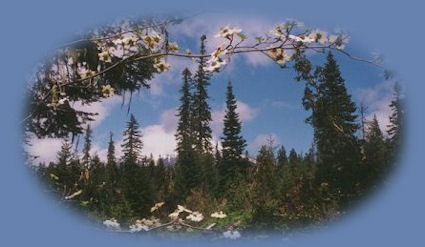
Traveling north from Medford Oregon on the Crater Lake Highway, or Oregon State Hwy 62, as otherwise known. Watch for the signs for Butte Falls 4.5 miles north of Eagle Point and just south of Shady Cove. If you find yourself in Shady Cove, you've gone too far. Turn right at the sign. Head east through the Cascade Mountains; take in some spectacular views of Mt McLoughlin on the southwestern flank. The photograph of wild dogwood above was taken when we pulled off |
|
|
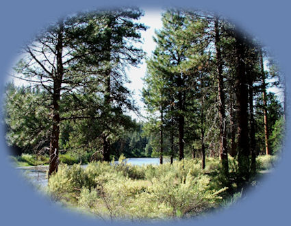
on one of the side roads. There is much to see if one just takes the time. Butte Falls 25 miles east of the turnoff, nestled at 2600 feet in the Cascade Mountains, is a picturesque logging town that boasts a small waterfall, two museums, a historical society and more. Stop and walk around, have a picnic at the city park. When ready to leave, just continue driving through the community, the road will connect with Hwy 140. Turn left and head east. Fish Lake is a small mountain lake on the right. Closer to the summit, Lake of the Woods offers the classic blue waters of a pristine mountain lake. The 43 mile marker on Hwy 140 is marked by the sign for Rocky Point and Fort Klamath. This is Westside Road. Turn left to drive around the north end of Klamath Lake. The sign for Rocky Point appears almost immediately. Canoe and Birding trails for the Upper Klamath National Wildlife Refuge can be accessed here (Map), as well as, Malone Springs, 4 miles further north on Westside Road. If you prefer, or if you care to take in more than one wetland on Upper Klamath Lake, take a brief detour and check out the Wood River Wetlands on the eastern side of the lake. After all, Klamath Basin is considered first place for birding in the west. To remain on the Diverse Loop Tour:Westside Road lasts for 16 miles; the mile markers always give indication of where you are. After traveling 16 miles, Westside Road turns into Seven Mile Road, down in the range land. Look off to your left and see Mt. Mazama, the peak of Crater Lake and Mt. Scott, which forms the eastern boundary of the lake. Stay on this road until it ends; turn right. Turn left in about a half of a mile. After turning left, continue until you come to Hwy 62, the Crater Lake Hwy, and you have to turn right or left. Turn left; follow 62 to drive through Fort Klamath and rangeland. Three miles north of Fort Klamath the road forks, stop at Kimball State Park to view the clear, beautiful aqua waters of the spring as they flow from a rocky hillside. Perhaps camp alongside the stream in the primitive, but adequate campground. Continue on Hwy 62 until you enter Crater Lake National Park at the south entrance. You can go either east or west, the rim drive circles the lake. The west rim drive is shorter than the east rim drive. The Phantom Ship is visible only from the eastern drive. Wizard Island can be viewed from many vistas around the rim, but is certainly more readily seen from the western rim drive. Also, Crater Lake boasts many beautiful hikes, so take your time. See as much as you can and take advantage of whatever beauty catches your eye. Exit the park at the north entrance. (At this point you could decide to leave the Diverse Loop Tour and take the Umpqua Waterfall Tour. To remain on the Diverse Loop Tour when leaving Crater Lake National Park:Turn left on Hwy 138, traveling briefly west and see the sign for Medford. Perhaps you might want to stop and check out Diamond Lake and maybe camp there before heading south towards Medford on Hwy 230. On Hwy 230, be sure to look for viewpoints of Mt Thielsen and get one of the most spectacular views of the mountain. (Mt. Thielsen is behind you as you drive.) Travel further south, and Rabbit Ears comes into view off to your right. The sign for National Creek Waterfall appears a little further south. The fall is a few miles drive on a FS road; then an approximate ½ mile hike. Drive no more than 3 or 4 miles further on 230 to the Rogue River and view a pretty cascade: the first view of the river from the road, unless you decided to stop at Rabbit Ears and walk through the forest to the edge of the bluff and look down. Be careful if you do; the drop off is quite substantial and there are no markers and no fence. If you wait for the cascade, it will be on your left. Cross a bridge soon after and the Rogue is on your right. Not long after, the sign for 62 heading east appears; at this point, 230 becomes 62. Stay on 62 heading south to see some views of the Rogue River at Union Creek where it forges through a narrow channel of volcanic rock before placidly settling into a peaceful river flow. The Natural Bridge is a lava tube through which the Rogue flows. Exit 62 at Prospect for the loop that will take you along Mill Creek. Prospect Hotel is a renovated late 1800s hotel. Several personages from the old west stayed there, President Grant also. Picturesque Mill Creek Bridge is just south of Prospect. The Avenue of Giant Boulders is viewable from the bridge, however, one can walk among the boulders taking either of two paths. One path originates just north of the bridge. Find a parking lot across the street and not far down from the General Store. Park the car and walk south to the stream. If you choose this hike, you will see Pearsoney Waterfall, and come out at the creek below the Avenue of Giant Boulders. Or you can walk to the Avenue of Giant Boulders and Mill and Barr Creek Falls from a trailhead a little further south of Mill Creek Bridge. The trailhead is clearly marked from the road, offering a small parking lot. The trails are short ~ only a walk really ~ and are well marked. This is Boise Cascade land, but the trails are open to the public. Leaving Mill and Barr Creek Waterfall: Turn left and continue heading south until the road connects once again with Hwy 62. Follow 62 into Medford, Oregon, and your tour is complete. Unless, you want to take our travel guide and head out to the South Umpqua River and those waterfalls by way of Tiller, Oregon. To Continue on to Ashland after reaching Medford:If you want to continue onto Ashland, Oregon and the Oregon Shakespearean Festival, follow Hwy 62 until you see the exits for I - 5. Several well known chain stores will help mark your way: Costco, Safeway, Wal-Mart and Fred Meyer on the left is the last before you must take the exit to the freeway. By the time you see Fred Meyer you should be in the right lane. Cross the overpass for the freeway, and immediately turn right into the acceleration lane for I -5. Follow I -5 south for about 10 miles until you see the exit for Ashland. There are three exits to Ashland. I am telling you the easiest one to get into the downtown area, and that's the first. After you exit I - 5 at the first exit, turn right at the stop sign. When you come to the traffic signal, turn left and follow Hwy 99 into Ashland. Turn right on the first street after you go over the little bridge that crosses Ashland Creek. (I call this part of town the hub.) Follow the street along Lithia Park. Look for parking along here. I've never had trouble finding parking in Ashland, and I've been there many, many times. Depending on the time of year, one can find parking close to the "hub" or further down along Lithia Park. | |
|
Travel Oregon and northern California while staying at Gathering Light ... a retreat | |
|
Travel the Rogue Umpqua Scenic Byway to the retreat: Directions, Map and Scenery or Medford Oregon. Directions to and Day Trips in Oregon and/or California of about 100 miles from the retreat. Little Known "Special Places" near Crater Lake National Park and the retreat: Travel Directions, Map and Scenery. Website Directory for the travel pages Home Page |
|
|
Contact Brad at Gathering Light ... a retreat. | |