hiking trails in the umpqua national forest, hiking to shadow waterfalls in the watershed of the wild and scenic umpqua river in the cascade mountains of oregon; enjoy camping in the umpqua national forest and hiking trails to waterfalls in the wild and scenic umpqua river watershedt: brice creek waterfalls, moon waterfalls, pinard waterfalls, spirit falls; hiking trails off the Rogue Umpqua Scenic byway on the wild and scenic umpqua river in the umpqua national forest: toketee waterfalls, watson falls hiking trails, fall creek falls, susan creek day use area, susan creek hiking trails, susan creek campgrounds off the rogue umpqua scenic byway, toketee campgrounds off the rogue umpqua scenic byway, lemolo campgrounds off the rogue umpqua scenic byway, diamond lake campgrounds, boulder creek campgrounds, canyon creek campgrounds, umpqua national forest campgrounds, clearwater falls campgroud, island campgrounds, lake in the woods campgrounds, bogus creek campgrounds, devil's campground on cow creek, cedar creek campground on brice creek, rujada campground on layng creek, apple creek campgrounds, whitehorse falls campground, susan creek waterfalls, north umpqua river, south umpqua river, umpqua river hiking trails accessed off the rogue umpqua scenic byway, forest service campgrounds, blm campgrounds, travel oregon through the cascade mountains, cavitt creek recreation area, deadline falls, steelhead in the umpqua river, angling, hiking trails to lemolo waterfalls, clearwater waterfalls, whitehorse waterfalls, clearwater river, toketee lake, umpqua hot springs, steamboat creek waterfalls, warm springs waterfalls, lemolo lake; hiking trails on the little river in the umpqua river watershed in the umpqua national forest: wolf creek waterfalls, grotto falls, hemlock waterfalls, hemlock lake, cavitt creek waterfalls, recreation area, shadow waterfalls, yakso waterfalls; hiking trails on the south umpqua river watershed: south umpqua waterfalls, campbell waterfalls, hiking trails in theboulder creek wilderness area, hiking trails in the mt thielsen rogue umpqua divide wilderness area, cathedral waterfalls off the south umpqua river; hiking trails in the row river watershed: moon, spirit and pinard waterfalls.
Hiking Trails:

Shadow Falls on Cavitt Creek:
Hiking trails in the Umpqua River Watershed:

I wanted to take this hiking trail for some time, but knew to do it earlier in the summer rather than later, so the hike never materialized. This spring I asked Brad if he wanted to go, and he wasn't interested. So I decided to do it on my own.

What an excellent decision! It was wonderful to be in the forest all by myself. No other human was up there. In truth, the weather wasn't conducive to hiking, but I had my rain gear, and I was born in Oregon. I like the rain. Although it never did rain; the forest just dripped - on me, on the trail, I sloshed through puddles ... I didn't care. When I saw Shadow Waterfalls I thought it was worth every drip and every splash :): Directions.

Forward ~ Heading down the mountain from
Shadow Falls.

Back ~ Hiking the trail to Shadow Falls.

USFS: Umpqua National Forest. BLM: Roseburg
District of the Bureau of Land Management.

Plan your visit to the many waterfalls and hiking trails in the Umpqua National Forest. Want to learn more about the campgrounds on the North Umpqua River and others in the Umpqua River watershed?

Protect our National Forests and Wilderness
Areas. Leave NO Trace!

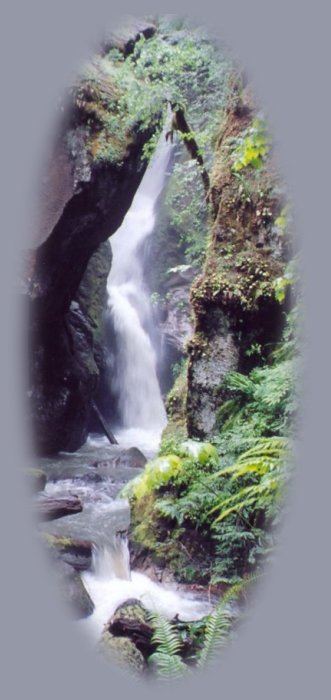
Directions to Shadow Waterfalls in the Umpqua National Forest:

In Glide, Oregon, on Hwy 138, east of Roseburg, find the North Umpqua Ranger Station on the north side of Hwy 138, just across the street from the Colliding Rivers Wayside. From there head west about a .1 of a mile. See the Little River Road on the left. Little River Road is County Road 17 turning into Forest Service Road 27.

Turn onto Little River Road. At the confluence of the Little River and Cavitt Creek, find Cavitt Creek Road (FS Rd 25, County Rd No. 82) about 7.5 miles after the turnoff onto Little River Rd. Just look for the historic covered bridge. Turn right onto Cavitt Creek Road. The trailhead for the waterfalls is appoximately 9 miles to Shadow Falls Trailhead on the right.

As an aside: Before the paved road turns to gravel, you'll come to the Cavitt Creek Recreation Area on the left. If you're interested stop for a look around, at least, if not more. It's a nice campground and picnic area, as well as a lovely waterfall.

Trailhead at Shadow Waterfalls 9 miles from the turnoff onto Cavitt Creek Road: Parking does not provide room to turn around for big rigs, but there are other opportunities nearby. (I'm taking this information from the Umpqua National Forest. I've never driven a 5th wheel or pick up with trailer out there. I drove a car :-). There's a vault toilet at the trailhead and one picnic table.

The trail passes through old growth and ends at viewing point beneath Shadow Falls. The trail itself provides much of interest. The creek and forest are magnificent, blooming with wildflowers in spring and early summer.

The trail is .8 mile each way. According to the Umpqua National Forest this is a difficult trail. It's also unsuitable for anything other than hiking or mountain biking.

 
Camping in the Umpqua National Forest & those areas managed by the Roseburg BLM

Directions to campgrounds in the Diamond Lake District of the Umpqua National Forest. Directions to campgrounds in the North Umpqua River district. The campgrounds for both districts are off the Rogue Umpqua Scenic Byway, many are on the wild and scenic Umpqua River. All fall between the north entrance to Crater Lake National Park and I-5 at Roseburg, Oregon. Boulder Flat is the last one in the North Umpqua district. After that you're in the Diamond Lake District. Directions to campgrounds in the Little River watershed of the North Umpqua River. Directions to camping facilities in the Row River watershed of the Umpqua River. Directions to campgrounds on the south Umpqua River also in the Umpqua River watershed.

 
Hiking Trails in the Umpqua River watershed in the Umpqua National Forest:

Directions for hiking trails to waterfalls and other points of interest in the Row River Watershed of the wild and scenic Umpqua River in the Umpqua National Forest. As well as Directions for the Umpqua River Trail - 12 hiking trails riverside. Directions for hiking trails to the many waterfalls on the wild and scenic Umpqua River off the Rogue Umpqua Scenic Byway. Directions for hiking trails in the south Umpqua watershed. Directions for hiking trails in the Little River watershed. All within the magnificent Umpqua National Forest.

Enjoy the North Umpqua Waterfalls Tour on the Rogue Umpqua Scenic Byway:

Can include Crater Lake National Park: Introduction.

Travel Directions, Map and Scenery ~ can include Crater Lake National Park: Introduction. Experience: splendid scenery, hiking trails for intrepid hikers and those with less enthusiam. Enjoy the magnificent the wild and scenic Umpqua River, Umpqua hot springs near Toketee Campground, rafting on the rapids, hiking the beautiful trail along the Umpqua gorge to magnificent Toketee Waterfalls, my favorite, and the favorite of anyone I've ever spoken to. Hike through a forest garden of dense wild rhododendrons at Warm Spring Waterfalls. Hike the trails to experience the wonder of tumultuous Watson Falls. Don't forget Lemolo Waterfalls and Lemolo Lake. And when you arrive at the north entrance partake the splendor of Crater Lake - Enjoy beauty.

Enjoy the Diverse Loop Tour on the Rogue Umpqua Scenic Byway and the Crater Lake Hwy:

Includes Crater Lake National Park: Introduction.

Travel Directions, Map and Scenery. Experience: splendid scenery, hiking trails for intrepid hikers and those with less enthusiam, experience the majestic Rogue River Gorge at Union Creek and the Natural Bridge, waterfalls, the Rogue River Hiking Trail, hiking trails to Muir Creek Waterfalls and National Creek Waterfalls all in the Rogue - Siskiyou National Forest. Enjoy hiking trails to Mill Creek Waterfalls, Barr Creek Waterfalls and Pearsoney Waterfalls in Prospect, Oregon. Or just stand on the historic Prospect bridge and enjoy the panorama of the Avenue of Giant Boulders. Hike down to the water's edge if you've a mind to.

Combine the Umpqua Waterfalls and the Diverse Loop Tours

Traveling Oregon on the Rogue Umpqua Scenic Byway and the Crater Lake Hwy: Directions.

stay in the cabins at gathering light retreat located in southern oregon near crater lake national park and and travel oregon and experience volcanoes, geology, hiking trails, oregon geology, rogue siskiyou national forest, wild and scenic rogue river, wild and scenic umpqua river, rogue gorge at union creek, oregon, national rogue river hiking trail, rogue national forest, national forests, wilderness areas, national wildlife refuges, wetlands, klamath basin, prospect, oregon, mill creek waterfalls on the rogue river, barr creek waterfalls on the rogue river, avenue of giant boulders on the rogue river, hiking trails to mill creek waterfalls, hiking trails to barr creek waterfalls on the rogue river, hiking trails to national creek waterfalls in the rogue siskiyou national forest, hiking trails along the rogue river, hiking trails to the natural bridge, hiking trails at crater lake national park, crater lake national park, hiking trails on the wild and scenic rogue river, hiking trails to national creek waterfalls, national wildlife refuges, wetlands, rabbit ears, the cascade mountains, the old cascade mountains, mt thielsen, hiking trails at crater lake, crater lake national park.  

Travel Oregon and northern California
while staying at Gathering Light ... a retreat
located in southern Oregon near Crater Lake National Park.

Advertise Here!

Travel on the Rogue Umpqua Scenic Byway to Gathering Light ... a retreat: Travel Directions Map and Scenery. Experience the columnar basalt of Toketee Waterfalls, tumultuous Watson Falls ... the beauty of the wild & scenic Umpqua River in the Umpqua National Forest. Arriving at the north entrance of Crater Lake, enjoy Crater Lake National Park too.

Travel Directions to and Day Trips of about 100 miles from the retreat.

Little known Scenic Places to explore nature: hiking trails, wetlands, national wildlife refuges, mountains, wilderness areas, river gorges and more near Crater Lake National Park and the retreat: Travel Directions, Map and Scenery.

Website Directory

Page Listing

Home Page

Wood River Wetlands, not far from Gathering Light ... a retreat,
depicted to the left.

Contact Brad at Gathering Light ... a retreat.

Valid XHTML 1.0 Transitional