| |
|
Brice creek in June, late spring, 2008. Camping in the Umpqua National Forest The Row River Watershed in the Umpqua National Forest Plan your visit to the many waterfalls and hiking trails in the Umpqua National Forest. Campgrounds on Brice Creek Cedar Creek Campground What a beautiful place: Brice Creek, the bridge at the trailhead for the hiking trail along Brice Creek. The canopy of old growth Doug firs shading campsites. Stairs making their way down to the creek from the campround - so lovely. Traveling on I-5, take exit 174 at Cottage Grove. Turn left at the stoplight onto Row River Road. Continue heading east this way. Don't turn left when the sign says, Row River Road to the left. Instead, follow Shoreview Drive until it rejoins Row river Road. Stay on Row River Road until you come to the "Y" offering the choice for Brice Creek to the right. Take the right. This is FS road 2470. Follow FS 2470 for 4.6 miles to Cedar Creek Campground. Fees: $6.00 a night for a family single, $3.00 for each additional vehicle. Drinking water: Hand Pump. Facilities: 10 campsites with picnic tables and 5 pits. 9 of the 10 campsites are combination tent/auto/trailer. One is a combination multi-family site. Garbage Service: Yes. Restrooms: Vault Toilets. Waste Water Pumps: 3. Parking is available at the campsites and at the bridge trailhead for Brice Creek hiking trail. Maximum Length of Stay: 14 days. Maximum Trailer Length: 16 foot. Reservations are not required. Open from May 20 to September 30. The Umpqua National Forest produces a guide to mineral collecting, which might be of interest. Enjoy hiking on beautiful Brice Creek hiking trail. Find Trestle Creek hiking trails at the end of the Brice Creek Trail, although you might want to drive down to the Champion Creek Trailhead for Brice Creek to access these trails, since Brice Creek hiking trail is 5.7 miles long. Swim in the beautiful pools along the way. Fishing, and recreational panning for gold are other possibilities, as well as using this location for a starting point for all the other hiking trails in the area. Directions for hiking trails in the area. Hobo Camp Campground Traveling on I-5, take exit 174 at Cottage Grove. Turn left at the stoplight onto Row River Road. Continue heading east this way. Don't turn left when the sign says, Row River Road to the left. Instead, follow Shoreview Drive until it rejoins Row river Road. Stay on Row River Road until you come to the "Y" offering the choice for Brice Creek to the right. Take the right. This is FS road 2470. Follow FS 2470 for 7.5 miles along Brice Creek - a lovely drive! The campground is located on both sides of FS Road 2470. It is used primarily by day use swimmers and picnickers. It's situated on a terrace above Brice Creek. A short trail leads to a beautiful cascading pool in Brice Creek. The campground offers flat ground for 2 to 4 trailers or RVs of up to 16 feet, a vault toilet, a total of 5 campsites and fire pit. Stays of up 14 days are allowed. There are No fees. No reservations are required. It's operable from May 15th to September 30 although the site does remain open in winter, albeit with reduced services. Enjoy camping, picnicking, swimming, hiking along Brice Creek, and access the Adams Mountain hiking trail .5 mile west of Hobo Camp. Adams Mountain hiking trail intersects with several hiking trails in the forest. Check with USFS: Umpqua National Forest for more information. Recreational gold panning is allowed. Hobo Camp has NO WATER. Nor does it have garbage service. Please pack your garbage out. Lund Park Campground Who could believe that a century ago a small community, of the name Lund Park, thrived here. Possessing a post office, hotel, dam, power house and other small structures. Lund Park was a stop over for miners making their way from Cottage Grove to the Bohemia Mining Area. Today only the foundation of one of the buildings remains. Traveling on I-5, take exit 174 at Cottage Grove. Turn left at the stoplight onto Row River Road. Continue heading east this way. Don't turn left when the sign says, Row River Road to the left. Instead, follow Shoreview Drive until it rejoins Row river Road. Stay on Row River Road until you come to the "Y" offering the choice for Brice Creek to the right. Take the right. This is FS road 2470. Follow FS 2470 for 7 miles along Brice Creek to the campground. Facilities 10 campsites with table and fire pit. Maximum length of trailer or RV: 16 feet. Yes, to garbage service. :-) 2 Vault Toilets. No Drinking Water. Fees: $6.00 for a family single and $3.00 for each additional vehicle. Reservations are not required, and the managed season is May 15 to September 30 although 3 campsites remain open year around offering reduced services. Enjoy picnicking, swimming, fishing and hiking on Brice Creek Trail. The hiking trail is accessed by the trail bridge located at Lund Park. Recreational panning for gold is allowed, and the Umpqua National Forest provides a guide to mineral collecting. Check with the Cottage Grove District Office: 541-767-5000. Campgrounds on Sharps Creek Sharps creek is not far from Brice Creek. If you camp here, you can have easy access to Brice Creek, depending on how far you want to drive. Mineral Camp Campground If you're on I-5, take exit 174 for Cottage Grove, turn left at the stop light, this is Row River Road, #2400. Follow Row River Road east 13 miles to Sharps Creek Road, #2460. In a few miles you'll see a sign that says, Row River Road to the left. Don't turn, just continue straight on Shore View Drive, it will connect with Row River Road in a few miles. Stay on Row River Road until you see the sign for Sharps Creek Road on the right. Turn right on Sharps Creek Road, #2460. Drive south for ten miles. Enjoy the scenery. :-) Turn left (east) continuing on the gravel portion of Sharps Creek Road, #2460, for another 2 miles. Mineral Camp is located on the south side of road #2460. Mineral Camp was once a stopover place for miners before starting up the long steep grade to the Bohemia Mining Area. Now, it's a small campground located on Sharps Creek at the base of historic Hardscrabble Grade. It offers 3 campsites with picnic tables and firepits, vault toilets, parking - NO water! NO garbage service, please pack it out. NO trailers. The Fairview Creek Trail begins from this campground. I've never taken this trail, so I cannot give any recommendations. As I understand it, however, the trail is offers lovely views of the creek's canyon, as well as old mining relics, which must be left in place. The trail is only maintained for one mile. Check with the Cottage Grove District Office of the Umpqua National Forest for more information. Fees: None. The campground is managed from March 15 to September 15. Use is moderate on weekdays and heavy on weekends during the summer months. Mineral Campground is under the auspices of the Umpqua National Forest. Sharps Creek Recreation Area From southbound I-5, take exit 174 at Cottage Grove. Turn left at the stoplight onto Row River Road. Follow Row River Road for about 4 miles. Don't turn left when the sign says, Row River to the left. Instead, continue straight on Shoreview Drive for 6.5 miles until it rejoins Row river Road. Merge onto Row River Road and travel for another 4 miles to Sharps Creek Road. Turn right and continue for 3 miles. The campground will be on your right, and the day use area on your left. Sharps Creek is a great area, offering many opportunities for recreation: hiking, swimming, picnicking, wildlife viewing, fishing, not to mention exploring the forest along beautiful creeks. Furthermore, want to try your hand panning for gold? Hiking trails abound in the area, not least, beautiful Brice Creek a few miles up the road. (You must return to Row River Road to get to Brice Creek.) There are beautiful creeks out here, mining claims all along the way. Fees for camping: $8.00 a night, and $3.00 for each additional car. Up to three vehicles are allowed with one campsite. This is a small family camping ground on one side of the road with a day use area on the other side. That's where you'll find the swimming hole. So cool. Sharps Creek Recreation Area is under the auspices of the BLM. Campgrounds on Layng Creek Rujada This is a lovely location. The campground registration booth was constructed by the CCC Corps in the 1930s. Brad and I have stopped here on several occasions just to walk around and view the creek. Sadly, we've yet to take Swordfern Hiking Trail, which follows Layng Creek into the canopied forest of Doug Fir and Swordfern understory. Something for later :-). Traveling on I-5, take exit 174 at Cottage Grove. Turn left at the stoplight onto Row River Road. Continue heading east this way. Don't turn left when the sign says, Row River Road to the left. Instead, follow Shoreview Drive until it rejoins Row river Road. Stay on Row River Road until you come to the "Y" offering the choice for Brice Creek to the right. Take the left onto Layng Creek Road, #17. Continue 2 miles to Rujada Campground on the right. Facilities 15 campsites with tables and tent pads: 12 combination tent/auto/trailer and 3 combination multi-family; 5 Day Use Picnic Sites, 2 group picnic sites (donations are gladly accepted). Maximum length of trailer or RV: 22 feet. Yes, to garbage service. :-) Flush and Vault Toilets. Pped Water. 4 waste water sumps. Parking. Campground Host. Fees: $8.00 for a family single and $3.00 for each additional vehicle. Reservations are not required, and the managed season is May 15 to September 30 although 3 campsites remain open year around offering reduced services. Enjoy fishing, hiking, picnicking, as well as the marvelous surrounding hiking trails to lovely waterfalls on both Layng and Brice Creeks. To find out more about Swordfern Hiking Trail check Directions to Swordfern Hiking Trail. For more information, contact the Cottage Grove District of the Umpqua National Forest: 541-767-5000, or the site for the Umpqua National Forest, as well as the Eugene Office for the BLM: 541-683-6600. | |
|
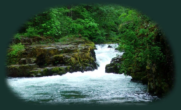
Forward ~ Hiking trails in the Row River watershed. Back ~ Scenery on the Rogue Umpqua Scenic Byway. USFS: Umpqua National Forest. Plan your visit to the many waterfalls and hiking trails The stairway to Brice Creek at Cedar Creek campground depicted to the right. This photo was taken one year in March - a wet March, I might add. |
|
|
Hiking Trails in the Umpqua River watershed in the Umpqua National Forest: Directions for hiking trails to waterfalls and other points of interest in the Row River Watershed of the wild and scenic Umpqua River in the Umpqua National Forest. As well as Directions for the Umpqua River Trail - 12 hiking trails riverside. Directions for hiking trails to the many waterfalls on the wild and scenic Umpqua River off the Rogue Umpqua Scenic Byway. Directions for hiking trails in the south Umpqua watershed. Directions for hiking trails in the Little River watershed. All within the magnificent Umpqua National Forest. Enjoy the North Umpqua Waterfalls Tour on the Rogue Umpqua Scenic Byway: Can include Crater Lake National Park: Introduction. Travel Directions, Map and Scenery ~ can include Crater Lake National Park: Introduction. Experience: splendid scenery, hiking trails for intrepid hikers and those with less enthusiam. Enjoy the magnificent the wild and scenic Umpqua River, Umpqua hot springs near Toketee Campground, rafting on the rapids, hiking the beautiful trail along the Umpqua gorge to magnificent Toketee Waterfalls, my favorite, and the favorite of anyone I've ever spoken to. Hike through a forest garden of dense wild rhododendrons at Warm Spring Waterfalls. Hike the trails to experience the wonder of tumultuous Watson Falls. Don't forget Lemolo Waterfalls and Lemolo Lake. And when you arrive at the north entrance partake the splendor of Crater Lake - Enjoy beauty. Enjoy the Diverse Loop Tour on the Rogue Umpqua Includes Crater Lake National Park: Introduction. Travel Directions, Map and Scenery. Experience: splendid scenery, hiking trails for intrepid hikers and those with less enthusiam, experience the majestic Rogue River Gorge at Union Creek and the Natural Bridge, waterfalls, the Rogue River Hiking Trail, hiking trails to Muir Creek Waterfalls and National Creek Waterfalls all in the Rogue - Siskiyou National Forest. Enjoy hiking trails to Mill Creek Waterfalls, Barr Creek Waterfalls and Pearsoney Waterfalls in Prospect, Oregon. Or just stand on the historic Prospect bridge and enjoy the panorama of the Avenue of Giant Boulders. Hike down to the water's edge if you've a mind to. Combine the Umpqua Waterfalls and the Diverse Loop Tours Traveling Oregon on the Rogue Umpqua Scenic Byway and the Crater Lake Hwy: Directions. Travel Oregon and northern California while staying at Gathering Light ... a retreat | |
|
Travel the Rogue Umpqua Scenic Byway, Hwy 138, to the retreat: Directions Map & Scenery. Experience the grandeur of Toketee, Lemolo & Watson Falls, the wild & scenic Umpqua & Crater Lake. Travel Directions to & Day Trips of about 100 miles from the retreat. Little known Scenic Places: hiking with & without trails, wetlands, birding trails, wildlife refuges, wildlife viewing, mountains, wilderness areas, river gorges & more near Crater Lake & the retreat: Directions, Map and Scenery. Website Directory for the travel pages Home Page Mt Scott on the eastern flank of Mt Mazama: Crater Lake, viewed over the Williamson River valley. |
|
|
Contact Brad at Gathering Light ... a retreat. |
|