lemolo lake reservoir on the umpqua river; enjoy camping in the umpqua national forest and hiking trails to waterfalls in the wild and scenic umpqua river watershedt: brice creek waterfalls, moon waterfalls, pinard waterfalls, spirit falls; hiking trails off the Rogue Umpqua Scenic byway on the wild and scenic umpqua river in the umpqua national forest: toketee waterfalls, watson falls hiking trails, fall creek falls, susan creek day use area, susan creek hiking trails, susan creek campgrounds off the rogue umpqua scenic byway, toketee campgrounds off the rogue umpqua scenic byway, lemolo campgrounds off the rogue umpqua scenic byway, diamond lake campgrounds, boulder creek campgrounds, canyon creek campgrounds, umpqua national forest campgrounds, clearwater falls campgroud, island campgrounds, lake in the woods campgrounds, bogus creek campgrounds, apple creek campground, steamboat falls campground, williams creek and eagle rock campgrounds, horseshoe bend and canton creek campgrounds, devil's campground on cow creek, cedar creek campground on brice creek, rujada campground on layng creek, whitehorse falls and clearwater falls campgrounds, susan creek waterfalls, north umpqua river, medicine creek native pictorgraphs, indian pictographs, south umpqua river, umpqua river hiking trails accessed off the rogue umpqua scenic byway, forest service campgrounds, blm campgrounds, cavitt creek recreation area, deadline falls, steelhead in the umpqua river, angling, hiking trails to lemolo waterfalls, clearwater waterfalls, whitehorse waterfalls, clearwater river, toketee lake, umpqua hot springs, steamboat creek waterfalls, warm springs waterfalls, lemolo lake; hiking trails on the little river in the umpqua river watershed in the umpqua national forest: wolf creek waterfalls, grotto falls, hemlock waterfalls, hemlock lake, cavitt creek waterfalls, recreation area, shadow waterfalls, yakso waterfalls; hiking trails on the south umpqua river watershed: south umpqua waterfalls, campbell waterfalls, hiking trails in the boulder creek wilderness area, hiking trails in the mt thielsen rogue umpqua divide wilderness area, old growth forests, cathedral waterfalls off the south umpqua river; hiking trails in the row river watershed: moon, spirit and pinard waterfalls.

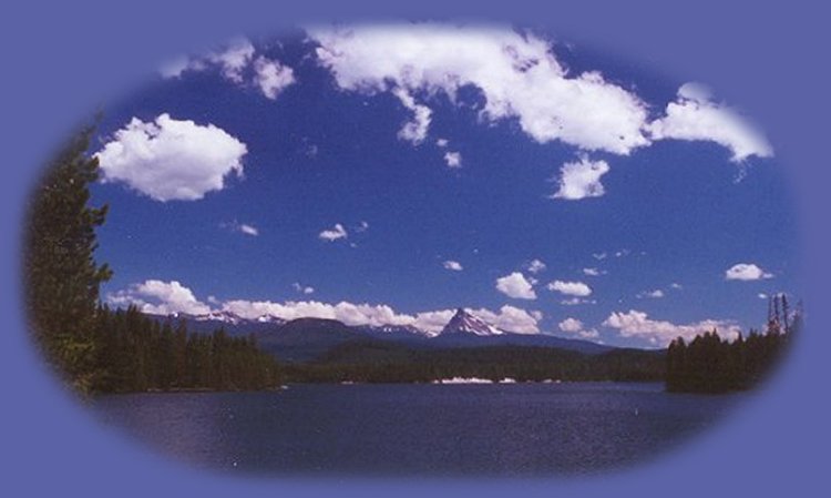
Campgrounds in the Umpqua National Forest

Lemolo Lake Reservoir on the Umpqua River.

Lemolo "Lake" Reservoir was formed with the damming of the Umpqua River. View Mt Thielsen (background) from the lake.

The reservoir offers much in the way of vacation recreation: Lemolo Lake Resort, camping at several USFS Campgrounds (see them listed below), as well as boating, fishing, water skiing, swimming; hiking trails to waterfalls, access to the Pacific Crest trail and the Umpqua River Trail. The hike to Toketee Waterfall is west within 15 miles from the turnoff of Hwy 138, to Watson Waterfalls: west within 10, & the opportunity to view and photograph Whitehorse & Clearwater Waterfalls: west within 5 and 7 respectively. The north entrance to Crater Lake is east within 20 miles of the turnoff from Hwy 138. (I'm estimating this distance, but if I'm off, it's not by much. I know this pass very well.- gm)

Fishing: The lake contains Kokanee, Eastern Brook, and a few Rainbow trout. Large German brown trout are wild native fish and can be taken on troll and fly.

Directions to the campgrounds on Lemolo Lake Reservoir: Umpqua National Forest

Poole Creek Campground

Poole Creek campground lies at the mouth of Poole Creek on the western shore of Lemolo Lake. Lemolo Lake is 72 miles east of Roseburg, Oregon on the Rogue Umpqua Scenic Byway, Hwy 138. Turn north onto FS Road 2610; the turnoff is marked from the highway. Drive 4 miles and turn right when you see the Poole Creek Campground sign. A Northwest Forest Pass is required to use the boat ramp.

The campground offers 59 campsites: tent, travel trailers up to 30' and RVs up to 35'. Tables are included, as well as fireplaces, running water, vault toilets, a boat ramp (Northwest Forest Pass required) and a swimming beach. A group camping area is also available. Reservations are required for this. To make reservations call: 877-444-6777. For more information: USFS: The Umpqua National Forest or call the Toketee Ranger Station: 541-498-2531.

* Other nearby campsites: Bunket Hill Forest service campground, Inlet Forest Service Campground, East Lemolo Forest Service Campground, as well as a full service resort, operating under permit of the Umpqua National Forest, which includes RV Camping, motel units, swiss chalets and more. The RV park offers full or partial hookups, a dump station, bathrooms, showers, and a laundromat.

Bunker Hill Campground

Bunker Hill Forest Service Campground is situated on the northwest shore of Lemolo Reservoir beneath the heavily wooded Bunker Hill. Lemolo Lake is 72 miles east of Roseburg, Oregon on the Rogue Umpqua Scenic Byway, Hwy 138. Turn north onto FS Road 2610; the turnoff is marked from the highway. Drive 5.5 miles. You'll cross the Lemolo Lake Dam. Turn right onto FS Road 2612, and drive until you see the campground.

The campground offers 8 campsites, both trailer (up to 22') and tent units, tables, fireplaces and vault toilets. There is no drinking water.. For more information: USFS: Umpqua National Forest or call the Toketee Ranger Station: 541-498-2531. * See above.

East Lemolo Campground

East Lemolo Forest service Campground is an informal campground, located on the southeast shore of the reservoir. Lemolo Lake is 72 miles east of Roseburg, Oregon on the Rogue Umpqua Scenic Byway, Hwy 138. Turn north onto FS Road 2610; drive 3 miles and turn right onto FS Road 2614, drive 2 more miles, turn left onto FS Road 2610-430. The campground is at the end of the road: .3 mile.

The campground offers and informal camping area with picnic tables, fire rings and vault toilets. There is no drinking water. The maximum trailer allowed is 22'> An RV dump station is available Daiamond Lake and Broken Arrow campgrounds. For more information: USFS: Umpqua National Forest or call Toketee Ranger Station: 541-498-2531. * See above.

Inlet Campground

Inlet campground is located along the reservoir, where the Umpqua River rushes into Lemolo Reservoir. Lemolo Lake is 72 miles east of Roseburg, Oregon on the Rogue Umpqua Scenic Byway, Hwy 138. Turn north onto FS Road 2610; the turnoff is marked from the highway. Drive 3 miles and turn right onto FS Road 2614, drive 2.5 miles to the campground entrance on the right.

This campground offers 14 campsites (trailers up to 25' and tents), picnic tables, fire rings, and vault toilets. There is no drinking water. For more information: USFS: Umpqua National Forest or call the Toketee Ranger Station: 541-498-2531. * See above.

Protect our National Forests and Wilderness Areas. Leave NO Trace!

Forward ~ Serenity at Crater Lake National Park.

Back ~ Wild & Untamed, Lemolo Falls.

USFS: Umpqua National Forest. BLM: Roseburg
District of the Bureau of Land Management.

Plan your visit to the many waterfalls and hiking trails in the Umpqua National Forest. Want to learn more about the campgrounds on the North Umpqua River and others in the Umpqua River watershed?

Oregon Grape growing wild in the Umpqua National Forest.

enjoy camping in the umpqua national forest and hiking trails to waterfalls in the wild and scenic umpqua river watershedt: brice creek waterfalls, moon waterfalls, pinard waterfalls, spirit falls; hiking trails off the Rogue Umpqua Scenic byway on the wild and scenic umpqua river in the umpqua national forest: toketee waterfalls, watson falls hiking trails, fall creek falls, susan creek day use area, susan creek hiking trails, susan creek campgrounds off the rogue umpqua scenic byway, toketee campgrounds off the rogue umpqua scenic byway, lemolo campgrounds off the rogue umpqua scenic byway, diamond lake campgrounds, boulder creek campgrounds, canyon creek campgrounds, umpqua national forest campgrounds, clearwater falls campgroud, island campgrounds, lake in the woods campgrounds, bogus creek campgrounds, apple creek campground, steamboat falls campground, williams creek and eagle rock campgrounds, horseshoe bend and canton creek campgrounds, devil's campground on cow creek, cedar creek campground on brice creek, rujada campground on layng creek, whitehorse falls and clearwater falls campgrounds, susan creek waterfalls, north umpqua river, medicine creek native pictorgraphs, indian pictographs, south umpqua river, umpqua river hiking trails accessed off the rogue umpqua scenic byway, forest service campgrounds, blm campgrounds, cavitt creek recreation area, deadline falls, steelhead in the umpqua river, angling, hiking trails to lemolo waterfalls, clearwater waterfalls, whitehorse waterfalls, clearwater river, toketee lake, umpqua hot springs, steamboat creek waterfalls, warm springs waterfalls, lemolo lake; hiking trails on the little river in the umpqua river watershed in the umpqua national forest: wolf creek waterfalls, grotto falls, hemlock waterfalls, hemlock lake, cavitt creek waterfalls, recreation area, shadow waterfalls, yakso waterfalls; hiking trails on the south umpqua river watershed: south umpqua waterfalls, campbell waterfalls, hiking trails in the boulder creek wilderness area, hiking trails in the mt thielsen rogue umpqua divide wilderness area, old growth forests, cathedral waterfalls off the south umpqua river; hiking trails in the row river watershed: moon, spirit and pinard waterfalls.

 
Camping in the Umpqua National Forest & those areas managed by the Roseburg BLM

Directions to campgrounds in the Diamond Lake District of the Umpqua National Forest. Directions to campgrounds in the North Umpqua River district. The campgrounds for both districts are off the Rogue Umpqua Scenic Byway, many are on the wild and scenic Umpqua River. All fall between the north entrance to Crater Lake National Park and I-5 at Roseburg, Oregon. Boulder Flat is the last one in the North Umpqua district. After that you're in the Diamond Lake District. Directions to campgrounds in the Little River watershed of the North Umpqua River. Directions to camping facilities in the Row River watershed of the Umpqua River. Directions to campgrounds on the south Umpqua River also in the Umpqua River watershed.

 
Hiking Trails in the Umpqua River watershed in the Umpqua National Forest:

Directions for hiking trails to waterfalls and other points of interest in the Row River Watershed of the wild and scenic Umpqua River in the Umpqua National Forest. As well as Directions for the Umpqua River Trail - 12 hiking trails riverside. Directions for hiking trails to the many waterfalls on the wild and scenic Umpqua River off the Rogue Umpqua Scenic Byway. Directions for hiking trails in the south Umpqua watershed. Directions for hiking trails in the Little River watershed. All within the magnificent Umpqua National Forest.

Enjoy the North Umpqua Waterfalls Tour on the Rogue Umpqua Scenic Byway:

Can include Crater Lake National Park: Introduction.

Travel Directions, Map and Scenery ~ can include Crater Lake National Park: Introduction. Experience: splendid scenery, hiking trails for intrepid hikers and those with less enthusiam. Enjoy the magnificent the wild and scenic Umpqua River, the diversity of the Umpqua National forest, Umpqua hot springs near Toketee Campground, rafting on the rapids, hiking the beautiful trail along the Umpqua gorge to magnificent Toketee Waterfalls, my favorite, and the favorite of anyone I've ever spoken to. Hike through a forest garden of dense wild rhododendrons at Warm Spring Waterfalls. Hike the trails to experience the wonder of tumultuous Watson Falls. Don't forget Lemolo Waterfalls and Lemolo Lake. And when you arrive at the north entrance partake the splendor of Crater Lake - Enjoy beauty.

Enjoy the Diverse Loop Tour on the Rogue Umpqua Scenic Byway and the Crater Lake Hwy:

Includes Crater Lake National Park: Introduction.

Travel Directions, Map and Scenery. Experience: splendid scenery, hiking trails for intrepid hikers and those with less enthusiam, experience the majestic Rogue River Gorge at Union Creek and the Natural Bridge, waterfalls, the Rogue River Hiking Trail, hiking trails to Muir Creek Waterfalls and National Creek Waterfalls all in the Rogue - Siskiyou National Forest. Enjoy hiking trails to Mill Creek Waterfalls, Barr Creek Waterfalls and Pearsoney Waterfalls in Prospect, Oregon. Or just stand on the historic Prospect bridge and enjoy the panorama of the Avenue of Giant Boulders. Hike down to the water's edge if you've a mind to.

Combine the Umpqua Waterfalls and the Diverse Loop Tours

Traveling Oregon on the Rogue Umpqua Scenic Byway and the Crater Lake Hwy: Directions.

Travel Oregon and northern California while staying at Gathering Light ... a retreat
located in southern Oregon near Crater Lake National Park.

stay in the cabins at gathering light retreat located in southern oregon near crater lake national park and travel oregon and experience volcanoes, geology, hiking trails, oregon geology, rogue siskiyou national forest, wild and scenic rogue river, wild and scenic umpqua river, rogue gorge at union creek, oregon, national rogue river hiking trail, rogue national forest, national forests, wilderness areas, national wildlife refuges, wetlands, klamath basin, prospect, oregon, mill creek waterfalls on the rogue river, barr creek waterfalls on the rogue river, avenue of giant boulders on the rogue river, hiking trails to mill creek waterfalls, hiking trails to barr creek waterfalls on the rogue river, hiking trails to national creek waterfalls in the rogue siskiyou national forest, hiking trails along the rogue river, hiking trails to the natural bridge, hiking trails at crater lake national park, crater lake national park, hiking trails on the wild and scenic rogue river, hiking trails to national creek waterfalls, national wildlife refuges, wetlands, rabbit ears, the cascade mountains, the old cascade mountains, mt thielsen, hiking trails at crater lake, crater lake national park.

Travel on the Rogue Umpqua Scenic Byway to Gathering Light ... a retreat: Directions Map & Scenery. Experience the columnar basalt of Toketee Waterfalls, tumultuous Watson Falls ... the wild & scenic Umpqua River in the Umpqua National Forest. Arriving at the north entrance, enjoy Crater Lake National Park too.

Directions to & Day Trips of about 100 miles from the retreat.

Little known Scenic Places to explore nature: hiking trails, wetlands, national wildlife refuges, mountains, wilderness areas, river gorges & more near Crater Lake National Park & the retreat: Travel Directions, Map & Scenery.

Website Directory      Page Listings       Home Page

Crater Lake at the northern end of Hwy 138, on the other side of Diamond Lake. Not far from the retreat either.

Contact Brad at Gathering Light ... a retreat.

Valid XHTML 1.0 Transitional