enjoy hiking trails to waterfalls in the wild and scenic umpqua river watershed in the umpqua national forest: brice creek waterfalls, moon waterfalls, pinard waterfalls, spirit falls; hiking trails off the Rogue Umpqua Scenic byway on the wild and scenic umpqua river in the umpqua national forest: toketee waterfalls, watson falls hiking trails, fall creek falls, susan creek day use area, susan creek hiking trails, susan creek campgrounds off the rogue umpqua scenic byway, toketee campgrounds off the rogue umpqua scenic byway, lemolo campgrounds off the rogue umpqua scenic byway, diamond lake campgrounds, boulder creek campgrounds, canyon creek campgrounds, umpqua national forest campgrounds, clearwater falls campgroud, island campgrounds, lake in the woods campgrounds, bogus creek campgrounds, devil's campground on cow creek, cedar creek campground on brice creek, rujada campground on layng creek, apple creek campgrounds, whitehorse falls campground, susan creek waterfalls, north umpqua river, south umpqua river, umpqua river hiking trails accessed off the rogue umpqua scenic byway, forest service campgrounds, blm campgrounds, travel oregon through the cascade mountains, cavitt creek recreation area, deadline falls, steelhead in the umpqua river, angling, hiking trails to lemolo waterfalls, clearwater waterfalls, whitehorse waterfalls, clearwater river, toketee lake, umpqua hot springs, steamboat creek waterfalls, warm springs waterfalls, lemolo lake; hiking trails on the little river in the umpqua river watershed in the umpqua national forest: deer creek waterfalls, grotto falls, hemlock waterfalls, hemlock lake, cavitt creek waterfalls, recreation area, shadow waterfalls, yakso waterfalls; hiking trails on the south umpqua river watershed: south umpqua waterfalls, campbell waterfalls, hiking trails in theboulder creek wilderness area, hiking trails in the mt thielsen rogue umpqua divide wilderness area, cathedral waterfalls off the south umpqua river; hiking trails in the row river watershed: moon, spirit and pinard waterfalls.
Hiking Trails

Moon Falls in the
Umpqua National Forest:

Moon Falls along with Spirit and Pinard Waterfalls in the wild and scenic Umpqua River watershed provide three lovely hiking trails to beautiful waterfalls in the Umpqua National Forest of the Oregon Cascade Mountains.

Moon Falls is just a drive out of Cottage Grove, Oregon and well worth it. Both the hike and the drive to the waterfall are exceptional. Gaze across steep mountain valleys and ravines, stately trees, and then ... the waterfall: Directions.

Plan your visit to the many waterfalls and hiking trails in the Umpqua National Forest. Want to learn more about the campgrounds on the North Umpqua River and others in the Umpqua River watershed?

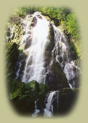
Directions to Moon Waterfall in the Umpqua National Forest:

Take exit 174 for Cottage Grove from I - 5. If you're heading south, this is the second exit.

The exit will just turn into the road you need. Follow it east for 19.4 miles until you see the "Y" marking Layng Creek and Brice Creek Roads. Turn left on Layng Creek Road (#17). Travel 9 miles to the gravel road numbered #1790. Turn right on 1790 and drive .3 mile to road #1702. Turn left, travel 2.8 miles to road 1702-728. Follow road 1701-728 for 0.3 miles before turning left on road 1702-203. From there it's just 0.1 mile to trailhead. Unless the situation has been amended, the trailhead is not clearly marked. I've never been there without wondering if this was the actual place, but it has always been. :)

The hike is a short half mile with the first 0.3-mile following a gentle grade to the upper fork of a closed spur road. The remaining 0.2-mile of trail travels through a beautiful old growth forest, terminating at the base a beautiful Moon Falls, a 125’ cascading waterfall. As stated above, the trail is located within Layng Creek Watershed, a municipal water supply for Row River community. Because of this, camping and swimming are prohibited here.

The above photograph was taken during late July or August. Obviously, the waterfall will flow more profusely earlier in the year, but I think it's loveliest as portrayed above. And if it's a hot day, the heavy mist that maintains the lush vegetation found here refreshes. :-)

This is a very easy hike. More of a stroll actually. Allow yourself at least 1.5 -2 hours for the hike in and out, giving time enough to explore the waterfalls and pool below. While exploring, be careful of slippery rocks and logs. The Umpqua National Forest judges the trail grades to be gentle, ranging from 5-10%.

Taking the "Silver Stairs" out of the Umpqua National Forest and into the Willamette National Forest:

If you like to explore, don't turn towards Cottage Grove when you've made your hikes and are ready to leave the area, turn in the opposite direction and follow the signs to Hwy 58, the Willamette Pass. This route is clearly marked. Nevertheless, I called the Cottage Grove Ranger Station of the Umpqua National Forest (541-767-5000) to confirm the "names" of the roads on the route. Not surprisingly, the representative knows the forest better than I do. She said that from Moon Falls you can get right onto 1714, which is the road you need. Getting onto 1714 isn’t clear to me, since we always just follow the signs. If you see 1714 when leaving the area of Moon Falls, perhaps you might just want to get on it and make your way.

Based upon what she said, Brad and I have always gotten onto 1790, and as I said it's clearly marked. We’ve gone this way after hiking to all the waterfalls in the Layng Watershed: Moon, Spirit and Pinard waterfalls. This route on 1790 is called "The Silver Stairs" locally - pretty name for a pretty place. According to what ranger said, 1790 will turn into 1714. To clarify any doubts you might have, Brad and I have never known the numbers of the route. A man who'd lived in the area for decades told us about it the first time we hiked at Brice Creek. We've taken it every time it's been late enough in the year to do so. The road is impassable until snowmelt, so don’t attempt it too early. It's a well maintained gravel road that turns into a paved road in the Willamette National Forest. The road is named when you come out on the Willamette Pass, Patterson Road.

As I said, the way from the Umpqua National Forest into the Willamette National Forest and Hwy 58 is clearly marked with signs that say, Hwy 58 and perhaps Oakridge. The last time I'd been to McCready Hot Springs, people had ridden their bikes from Brice Creek to Hwy 58, and from there to McCready. They were cooking eggs where the water comes out from underground - Interesting people. :-)

enjoy hiking trails to waterfalls in the wild and scenic umpqua river watershed in the umpqua national forest: brice creek waterfalls, moon waterfalls, pinard waterfalls, spirit falls; hiking trails off the Rogue Umpqua Scenic byway on the wild and scenic umpqua river in the umpqua national forest: toketee waterfalls, watson falls hiking trails, fall creek falls, susan creek day use area, susan creek hiking trails, susan creek campgrounds off the rogue umpqua scenic byway, toketee campgrounds off the rogue umpqua scenic byway, lemolo campgrounds off the rogue umpqua scenic byway, diamond lake campgrounds, boulder creek campgrounds, canyon creek campgrounds, umpqua national forest campgrounds, clearwater falls campgroud, island campgrounds, lake in the woods campgrounds, bogus creek campgrounds, devil's campground on cow creek, cedar creek campground on brice creek, rujada campground on layng creek, apple creek campgrounds, whitehorse falls campground, susan creek waterfalls, north umpqua river, south umpqua river, umpqua river hiking trails accessed off the rogue umpqua scenic byway, forest service campgrounds, blm campgrounds, travel oregon through the cascade mountains, cavitt creek recreation area, deadline falls, steelhead in the umpqua river, angling, hiking trails to lemolo waterfalls, clearwater waterfalls, whitehorse waterfalls, clearwater river, toketee lake, umpqua hot springs, steamboat creek waterfalls, warm springs waterfalls, lemolo lake; hiking trails on the little river in the umpqua river watershed in the umpqua national forest: deer creek waterfalls, grotto falls, hemlock waterfalls, hemlock lake, cavitt creek waterfalls, recreation area, shadow waterfalls, yakso waterfalls; hiking trails on the south umpqua river watershed: south umpqua waterfalls, campbell waterfalls, hiking trails in theboulder creek wilderness area, hiking trails in the mt thielsen rogue umpqua divide wilderness area, cathedral waterfalls off the south umpqua river; hiking trails in the row river watershed: moon, spirit and pinard waterfalls.

Forward ~ Pinard Waterfall
in the Row River Watershed in the Umpqua National Forest.

Back ~ The lacy flows of Spirit Waterfalls in the Umpqua National Forest.

USFS: Umpqua National Forest. BLM: Roseburg
District of the Bureau of Land Management.

Poison Oak can be a problem.

Protect our National Forests and Wilderness Areas.
Leave NO Trace!

The photograph to the left was taken on the hiking trail to Fall Creek Waterfalls on the wild and scenic Umpqua River, off the Rogue Umpqua Scenic Byway in the Umpqua National Forest.

Campgrounds in the Row River Watershed

Brice Creek: Cedar Creek Campground, Lund Campground and Hobo Campground.

Sharps Creek: Mineral Camp Campground. Sharps Creek Recreation Area, not associated with the Umpqua National Forest, can be found on Sharps Creek also. It has a great swimming hole.

Layng Creek: Rujada Campground. For more information on camping in the Row River watershed ...

 
Camping in the Umpqua National Forest & those areas managed by the Roseburg BLM

Directions to campgrounds in the Diamond Lake District of the Umpqua National Forest. Directions to campgrounds in the North Umpqua River district. The campgrounds for both districts are off the Rogue Umpqua Scenic Byway, many are on the wild and scenic Umpqua River. All fall between the north entrance to Crater Lake National Park and I-5 at Roseburg, Oregon. Boulder Flat is the last one in the North Umpqua district. After that you're in the Diamond Lake District. Directions to campgrounds in the Little River watershed of the North Umpqua River. Directions to camping facilities in the Row River watershed of the Umpqua River. Directions to campgrounds on the south Umpqua River also in the Umpqua River watershed.

 
Hiking Trails in the Umpqua River watershed in the Umpqua National Forest

Directions for hiking trails to waterfalls and other points of interest in the Row River Watershed of the wild and scenic Umpqua River in the Umpqua National Forest. As well as Directions for the Umpqua River Trail - 12 hiking trails riverside. Directions for hiking trails to the many waterfalls on the wild and scenic Umpqua River off the Rogue Umpqua Scenic Byway. Directions for hiking trails in the south Umpqua watershed. Directions for hiking trails in the Little River watershed. Most within the magnificent Umpqua National Forest.

The North Umpqua Waterfalls Tour on the Rogue Umpqua Scenic Byway:

Can include Crater Lake National Park: Introduction.

Travel Directions, Map and Scenery ~ can include Crater Lake National Park: Introduction. Experience: splendid scenery, hiking trails for intrepid hikers and those with less enthusiam. Enjoy the magnificent the wild and scenic Umpqua River, Umpqua hot springs near Toketee Campground, rafting on the rapids, hiking the beautiful trail along the Umpqua gorge to magnificent Toketee Waterfalls, my favorite, and the favorite of anyone I've ever spoken to. Hike through a forest garden of dense wild rhododendrons at Warm Spring Waterfalls. Hike the trails to experience the wonder of tumultuous Watson Falls. Don't forget Lemolo Waterfalls and Lemolo Lake. And when you arrive at the north entrance partake the splendor of Crater Lake - Enjoy beauty.

The Diverse Loop Tour on the Rogue Umpqua Scenic Byway & the Crater Lake Hwy:

Includes Crater Lake National Park: Introduction.

Travel Directions, Map and Scenery. Experience: splendid scenery, hiking trails for intrepid hikers and those with less enthusiam, experience the majestic Rogue River Gorge at Union Creek and the Natural Bridge, waterfalls, the Rogue River Hiking Trail, hiking trails to Muir Creek Waterfalls and National Creek Waterfalls all in the Rogue - Siskiyou National Forest. Enjoy hiking trails to Mill Creek Waterfalls, Barr Creek Waterfalls and Pearsoney Waterfalls in Prospect, Oregon. Or just stand on the historic Prospect bridge and enjoy the panorama of the Avenue of Giant Boulders. Hike down to the water's edge if you've a mind to.

Combine the Umpqua Waterfalls and the Diverse Loop Tours

Traveling Oregon on the Rogue Umpqua Scenic Byway and the Crater Lake Hwy: Directions.

Travel Oregon and southern California while staying at Gathering Light ... a retreat
located in southern Oregon near Crater Lake National Park.

stay in the cabins at Gathering Light retreat located in southern Oregon near Crater Lake and travel oregon and experience volcanoes, geology, hiking trails, oregon geology, rogue siskiyou national forest, wild and scenic rogue river, wild and scenic umpqua river, rogue gorge at union creek, oregon, national rogue river hiking trail, rogue national forest, national forests, wilderness areas, national wildlife refuges, wetlands, klamath basin, prospect, oregon, mill creek waterfalls on the rogue river, barr creek waterfalls on the rogue river, avenue of giant boulders on the rogue river, hiking trails to mill creek waterfalls, hiking trails to barr creek waterfalls on the rogue river, hiking trails to national creek waterfalls in the rogue siskiyou national forest, hiking trails along the rogue river, hiking trails to the natural bridge, hiking trails at crater lake national park, crater lake national park, hiking trails on the wild and scenic rogue river, hiking trails to national creek waterfalls, national wildlife refuges, wetlands, rabbit ears, the cascade mountains, the old cascade mountains, mt thielsen, hiking trails at crater lake, crater lake national park.  

Advertise Here!

Travel to Gathering Light ... a retreat on the North Umpqua Scenic Byway: Travel Directions Map and Scenery. Experience the columnar basalt of Toketee Waterfalls, the magnificent Watson Falls, the beauty of the Umpqua River as you drive, the "Keeper", Deadline Falls, a class 5 rapid, the Salmon returning to span from May through July - Enjoy the wild and scenic river. When you come to the north entrance of Crater Lake, enjoy Crater Lake National Park too.

Travel Directions to and Day Trips of about 100 miles from the retreat.

Little known Scenic Places to nature untrammeled: hiking with and without trails, wetlands, national wildlife refuges, mountains, wilderness areas, river gorges and more near Crater Lake National Park and the retreat: Travel Directions, Map and Scenery.

Website Directory

Page Listings

Home Page

Photograph to the left was taken at Wood River Wetlands in early September. Not far from Gathering Light ... a retreat.

Contact Brad at Gathering Light ... a retreat.

Valid XHTML 1.0 Transitional