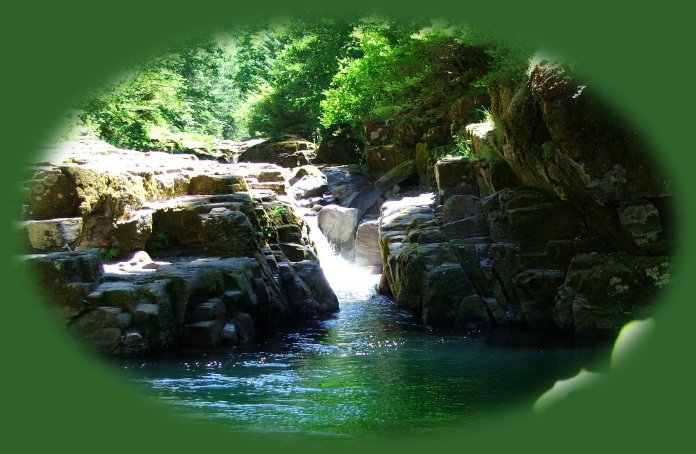
hiking along brice creek; hiking trails to waterfalls in the wild and scenic umpqua river watershed in the umpqua national forest: brice creek waterfalls, moon waterfalls, pinard waterfalls, spirit falls; hiking trails off the Rogue Umpqua Scenic byway on the wild and scenic umpqua river in the umpqua national forest: toketee waterfalls, watson falls hiking trails, fall creek falls, susan creek day use area, susan creek hiking trails, susan creek campgrounds off the rogue umpqua scenic byway, toketee campgrounds off the rogue umpqua scenic byway, lemolo campgrounds off the rogue umpqua scenic byway, diamond lake campgrounds, boulder creek campgrounds, canyon creek campgrounds, umpqua national forest campgrounds, clearwater falls campgroud, island campgrounds, lake in the woods campgrounds, bogus creek campgrounds, devil's campground on cow creek, cedar creek campground on brice creek, rujada campground on layng creek, apple creek campgrounds, whitehorse falls campground, susan creek waterfalls, north umpqua river, south umpqua river, umpqua river hiking trails accessed off the rogue umpqua scenic byway, forest service campgrounds, blm campgrounds, travel oregon through the cascade mountains, cavitt creek recreation area, deadline falls, steelhead in the umpqua river, angling, hiking trails to lemolo waterfalls, clearwater waterfalls, whitehorse waterfalls, clearwater river, toketee lake, umpqua hot springs, steamboat creek waterfalls, warm springs waterfalls, lemolo lake; hiking trails on the little river in the umpqua river watershed in the umpqua national forest: deer creek waterfalls, grotto falls, hemlock waterfalls, hemlock lake, cavitt creek waterfalls, recreation area, shadow waterfalls, yakso waterfalls; hiking trails on the south umpqua river watershed: south umpqua waterfalls, campbell waterfalls, boulder creek wilderness area, cathedral waterfalls.
Hiking Trails

Hiking on Brice Creek in the Umpqua National Forest

Brice Creek is in the Row River watershed of the Umpqua River watershed.
The Umpqua, a wild and scenic river, is in the High and Old Cascade Mountains of Oregon.

Travel Directions to the hiking trails at Brice Creek

Traveling on I - 5, take exit 174 for Cottage Grove. As you exit the freeway, the road curves around. To go to Brice Creek turn left at the traffic signal. This is Row River Road. In the directions given on the site for the Umpqua National Forest, the author tells you to stay on Row River Road, and you can do this. Howerver, it's longer if you do. We always continue straight on a much shorter access road. Once we stayed on Row River Road to see just what there was to see. We made a long loop around the other side of Dorena Lake, the reservoir. We saw the dam if you're interested. After several miles Row River Road connected with the much shorter spur we usually take. So if you don't want to take the much longer route, just go straight when you see the sign on the left, telling you to turn left for Row River Road. For myself, I don't see any advantage to driving that extra distance, but I wouldn't have known I felt this way if we hadn't done it at least once. So it's your call. :-)

Continue this way until you see the Y, the road to the left, Layng Creek Road, 17, goes out to Layng Creek and other hiking trails to different waterfalls: Spirit Falls, Moon Falls and Pinard Falls. The road to the right is Brice Creek Road, 2470. Turn right.

Drive 3.3 miles from the Y to the West trailhead.

Drive 4.6 miles from the Y to the Cedar Creek Campground trailhead.

Drive 6.9 miles from the Y to the Lund Park Trailhead, or

Drive 8.2 miles from the Y to the Champion Creek Trailhead. Hiking the Brice Creek trail from the Champion Creek Trailhead means you'll be walking downstream, and it's prettier walking upstream.

Brice Creek Trail is 5.7 miles long. I have never walked the entire length because we're usually trying to accomplish more than a hike back and forth on Brice Creek in a day. Not that the creek isn't beautiful. It is, as can be seen in the above photograph taken in August one year. We always begin at Cedar Creek Campground, cross the bridge and head upstream from there. The trail to Trestle Creek Waterfalls is accessed near the eastern end of the hiking trail for Brice Creek. The trail to lower Trestle Creek Waterfalls, 1403C, clearly marked, is only .25 mile. It's an easy hike. The trail to upper Trestle Creek Waterfalls, 1403D, is more difficult and 2.6 miles long. By all means, don't confine your trip to hiking along the creek entirely. This is a very beautiful area, with much to offer in scenery, as I hope you'll see from the pages coming up after we leave the hiking trail and drive along the creek.

This is a popular trail with hikers, experienced bicyclists and joggers.

Be sure to contact the Cottage Grove Ranger Station: 541-767-5000, before taking out if you're driving any distance. I've tried to do the hike to Trestle Creek waterfalls four times, and it hasn't worked out any of those times. Once men were dynamiting the trail. We couldn't even do the hike on Brice Creek that day. Obviously it would have been good to have known this before we got there. :) -gm

Forward ~ Spring Seasonal Waterfall on Brice Creek.

Back ~ Wildwood Falls on Brice Creek, a Lane County Park,
east of Cottage Grove, Oregon.

USFS: Umpqua National Forest.

Poison Oak can be a problem.

Plan your visit to the many waterfalls and hiking trails in the Umpqua National Forest. Want to learn more about the campgrounds on the North Umpqua River and others in the Umpqua River watershed?

hiking trails to waterfalls in the wild and scenic umpqua river watershed in the umpqua national forest: brice creek waterfalls, moon waterfalls, pinard waterfalls, spirit falls; hiking trails off the Rogue Umpqua Scenic byway on the wild and scenic umpqua river in the umpqua national forest: toketee waterfalls, watson falls hiking trails, fall creek falls, susan creek day use area, susan creek hiking trails, susan creek campgrounds off the rogue umpqua scenic byway, toketee campgrounds off the rogue umpqua scenic byway, lemolo campgrounds off the rogue umpqua scenic byway, diamond lake campgrounds, boulder creek campgrounds, canyon creek campgrounds, umpqua national forest campgrounds, clearwater falls campgroud, island campgrounds, lake in the woods campgrounds, bogus creek campgrounds, devil's campground on cow creek, cedar creek campground on brice creek, rujada campground on layng creek, apple creek campgrounds, whitehorse falls campground, susan creek waterfalls, north umpqua river, south umpqua river, umpqua river hiking trails accessed off the rogue umpqua scenic byway, forest service campgrounds, blm campgrounds, travel oregon through the cascade mountains, cavitt creek recreation area, deadline falls, steelhead in the umpqua river, angling, hiking trails to lemolo waterfalls, clearwater waterfalls, whitehorse waterfalls, clearwater river, toketee lake, umpqua hot springs, steamboat creek waterfalls, warm springs waterfalls, lemolo lake; hiking trails on the little river in the umpqua river watershed in the umpqua national forest: deer creek waterfalls, grotto falls, hemlock waterfalls, hemlock lake, cavitt creek waterfalls, recreation area, shadow waterfalls, yakso waterfalls; hiking trails on the south umpqua river watershed: south umpqua waterfalls, campbell waterfalls, boulder creek wilderness area, cathedral waterfalls.  

Campgrounds in the Row River Watershed

Brice Creek: Cedar Creek Campground, Lund Campground and Hobo Campground.

Sharps Creek: Mineral Camp Campground. Sharps Creek Recreation Area, not associated with the Umpqua National Forest, can be found on Sharps Creek also. It has a great swimming hole.

Layng Creek: Rujada Campground. For more information on camping in the Row River watershed ...

 
Camping in the Umpqua National Forest & those areas managed by the Roseburg BLM

Directions to campgrounds in the Diamond Lake District of the Umpqua National Forest. Directions to campgrounds in the North Umpqua River district. The campgrounds for both districts are off the Rogue Umpqua Scenic Byway, many are on the wild and scenic Umpqua River. All fall between the north entrance to Crater Lake National Park and I-5 at Roseburg, Oregon. Boulder Flat is the last one in the North Umpqua district. After that you're in the Diamond Lake District. Directions to campgrounds in the Little River watershed of the North Umpqua River. Directions to camping facilities in the Row River watershed of the Umpqua River. Directions to campgrounds on the south Umpqua River also in the Umpqua River watershed.

 
Hiking Trails in the Umpqua River watershed in the Umpqua National Forest:

Directions for hiking trails to waterfalls and other points of interest in the Row River Watershed of the wild and scenic Umpqua River in the Umpqua National Forest. As well as Directions for the Umpqua River Trail - 12 hiking trails riverside. Directions for hiking trails to the many waterfalls on the wild and scenic Umpqua River off the Rogue Umpqua Scenic Byway. Directions for hiking trails in the south Umpqua watershed. Directions for hiking trails in the Little River watershed. All within the magnificent Umpqua National Forest.

Enjoy the North Umpqua Waterfalls Tour on the Rogue Umpqua Scenic Byway:

Can include Crater Lake National Park: Introduction.

Travel Directions, Map and Scenery ~ can include Crater Lake National Park: Introduction. Experience: splendid scenery, hiking trails for intrepid hikers and those with less enthusiam. Enjoy the magnificent the wild and scenic Umpqua River, Umpqua hot springs near Toketee Campground, rafting on the rapids, hiking the beautiful trail along the Umpqua gorge to magnificent Toketee Waterfalls, my favorite, and the favorite of anyone I've ever spoken to. Hike through a forest garden of dense wild rhododendrons at Warm Spring Waterfalls. Hike the trails to experience the wonder of tumultuous Watson Falls. Don't forget Lemolo Waterfalls and Lemolo Lake. And when you arrive at the north entrance partake the splendor of Crater Lake - Enjoy beauty.

Enjoy the Diverse Loop Tour on the Rogue Umpqua Scenic Byway and the Crater Lake Hwy:

Includes Crater Lake National Park: Introduction.

Travel Directions, Map and Scenery. Experience: splendid scenery, hiking trails for intrepid hikers and those with less enthusiam, experience the majestic Rogue River Gorge at Union Creek and the Natural Bridge, waterfalls, the Rogue River Hiking Trail, hiking trails to Muir Creek Waterfalls and National Creek Waterfalls all in the Rogue - Siskiyou National Forest. Enjoy hiking trails to Mill Creek Waterfalls, Barr Creek Waterfalls and Pearsoney Waterfalls in Prospect, Oregon. Or just stand on the historic Prospect bridge and enjoy the panorama of the Avenue of Giant Boulders. Hike down to the water's edge if you've a mind to.

Combine the Umpqua Waterfalls and the Diverse Loop Tours

Traveling Oregon on the Rogue Umpqua Scenic Byway and the Crater Lake Hwy: Directions.

Travel Oregon and southern California while staying at Gathering Light ... a retreat
located in southern Oregon near Crater Lake National Park.

Travel on the Rogue Umpqua Scenic Byway to Gathering Light ... a retreat: Directions Map & Scenery. Experience the columnar basalt of Toketee Waterfalls, tumultuous Watson Falls ... the wild & scenic Umpqua River. Arriving at the north entrance, enjoy Crater Lake National Park too.

Travel Directions to & Day Trips of about 100 miles from the retreat.

Little known Scenic Places to explore nature: hiking, with and without, trails, wetlands, national wildlife refuges, mountains, wilderness areas, river gorges & more near Crater Lake National Park & the retreat: Travel Directions, Map & Scenery.

stay in the cabins at Gathering Light retreat located in southern Oregon near Crater Lake National Park and travel oregon and experience volcanoes, geology, hiking trails, oregon geology, rogue siskiyou national forest, wild and scenic rogue river, wild and scenic umpqua river, rogue gorge at union creek, oregon, national rogue river hiking trail, rogue national forest, national forests, wilderness areas, national wildlife refuges, wetlands, klamath basin, prospect, oregon, mill creek waterfalls on the rogue river, barr creek waterfalls on the rogue river, avenue of giant boulders on the rogue river, hiking trails to mill creek waterfalls, hiking trails to barr creek waterfalls on the rogue river, hiking trails to national creek waterfalls in the rogue siskiyou national forest, hiking trails along the rogue river, hiking trails to the natural bridge, hiking trails at crater lake national park, crater lake national park, hiking trails on the wild and scenic rogue river, hiking trails to national creek waterfalls, national wildlife refuges, wetlands, rabbit ears, the cascade mountains, the old cascade mountains, mt thielsen, hiking trails at crater lake, crater lake national park.

Website Directory

Page Listings

Home Page


Contact Brad at Gathering Light ... a retreat.

Valid XHTML 1.0 Transitional