Taklema Gorge
| |
|
|
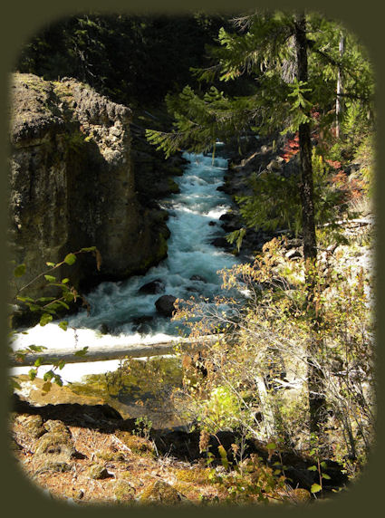
Brad and I decided to take this segment of the upper Rogue wild and scenic hiking trail first. We had no idea what we'd find. We were just looking for a nice walk along the river, and the rest would come as a suprise. Well, Takelma Gorge was a surprise when we came upon it, and a magnificent one. Forward ~ The river isn't always that peaceful: Takelma Gorge on the upper Rogue wild and scenic river hiking trail. Back ~ Pearsoney Waterfalls, hiking the path to the south fork of the Rogue River, found in Prospect Oregon. USFS: Rogue River Siskiyou National Forest in Oregon. Poison Oak can be a problem at these elevations. Want to see a picture. Indeed, I took this picture near here, at the viewpoint for Mill Creek and Barr Creek Waterfalls! |
|
This segment of the hiking trail runs from Woodruff Bridge picnic area to the River Bridge campground. It is 4.6 miles one way, so if you don't want to walk 9.2 miles ... make plans. :-) It's an easy walk, the USFS rates it easiest. Even so, it's not suitable for Pack and Saddle, Mountain Bike, Motorized Bike, ATV, 4-Wheel Drive. I suppose it's because it's barrier free. This walk is beautiful! The wild raging character of the Upper Rogue River passing through Takelma Gorge is a key attraction. Not surprising at all. And it can only be seen if one elects to walk along the river. As stated above the hiking trail begins at the Woodruff Bridge Picnic Area on Forest Service road 68, the trail heads downstream. From there it wanders past a scarred, eroded pumice slope on the opposite bank. Alder, vine maple, cow parsnip, and horsetail line the river until it reaches the dark-colored lava cliffs of Takelma Gorge, 1.5 miles south. Here the river drops through a series of rapids and turns sharply to enter the gorge itself. The narrow channel continues for 0.5 miles. This section of trail has a rocky tread with a few steeper grades. Below Takelma Gorge, the river widens and flows calmly past the Union Rogue Baptist Church Camp, while the trail returns to pumice flats along the river. Raptors, such as the shy goshawk, can be seen on this section of the river. The trail ends at the River Bridge Campground on Forest Service road 6210. From Prospect drive north on the Crater Lake Hwy, Oregon Hwy. 62 until you reach the Woodruff Bridge Picnic Area. From there you'll see the trailhead. Protect our National Forests and Wilderness Areas. Leave NO Trace! | |
|
Explore the Diverse Loop Tour on the Rogue Umpqua Scenic Byway and Crater Lake Hwy: Directions, Map; and Scenery: waterfalls, hiking trails, the Rogue River Gorge at Union Creek, Oregon, the Natural Bridge, the Cascade Mountains, Diamond Lake, Crater Lake and more. Or the Umpqua Waterfall Tour on the Rogue Umpqua Scenic Byway: Travel Directions, Map and Scenery: wild and scenic rivers, waterfalls, hiking trails, Crater Lake; hot springs. Autumn hiking on the Rogue River National Hiking Trail in Oregon, pictured to the right. |
|
|
Combine the Diverse Loop Tour & Umpqua Waterfall Tour to travel the Rogue Umpqua Scenic Byway & Crater Lake Hwy: Directions & Map. Want to hike at Crater Lake National Park in Oregon? Find the hiking trails up at Crater Lake. Travel Oregon and northern California while staying at Gathering Light ... a retreat | |
|
Travel on the Rogue Umpqua Scenic Byway to Gathering Light ... a retreat: Travel Directions, Map & Scenery: hiking trails, waterfalls, the wild & scenic Rogue River, the wild & scenic Umpqua River; Crater Lake National Park & more. Directions to and Day Trips in Oregon and California of around 100 miles from the retreat. Little known Scenic Places to explore: wetlands, wildlife refuges, hiking, trails, sightseeing, wildlife viewing, birding, canoeing and more near the retreat and Crater Lake National Park: Travel Directions Map and Scenery. |
|
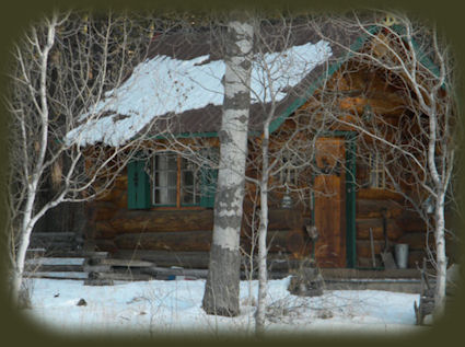
Contact Brad at Gathering Light ... a retreat. The log cabin photographed in a winter walk along the river at Gathering Light, pictured above. | |