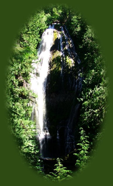
Proxy Waterfalls

Hiking trails to the Upper Waterfall
on the McKenzie Pass - Santiam Pass
Oregon Scenic Byway

Forward ~ Autumn on the McKenzie
Pass - Santiam Pass Oregon Scenic Byway.

Back ~ Hiking to Proxy Waterfalls: the Lower Fall.

A Northwest Forest Pass is required.

USFS: Willamette National Forest.

The hiking trail to Proxy Waterfalls is a 1.25 mile loop. The trail has some steep rises at the beginning of the hike, but the hike is easy. Besides offering two distinct and beautiful waterfalls, the trail wanders through open lava flows and dense forests. It's a lovely hike with plenty of parking. Directions to Proxy Waterfalls and other hiking trails on the McKenzie Pass Santiam Pass Oregon Scenic Byway.

Other sites to see on the McKenzie Pass - Santiam Pass Oregon Scenic Byway, Hwy 242.

Explore the West Cascades National Scenic Byway: Travel Directions, Map and Scenery: mountains, hardened lava flows, wild and scenic rivers, waterfalls, hiking trails, hot springs, old growth forests, mountain lakes, wildflowers, campgrounds.

Travel the Willamette Pass in the Cascade Mountains: Travel Directions, Map and Scenery, and/or the Crescent Lake, Oakridge "Inback" Tour: Travel Directions and Map.

Protect our National Forests
and Wilderness Areas.
Leave NO Trace!

travel oregon on the west cascades national scenic byway and the mckenzie pass - santiam pass oregon scenic byway, hwy 242, and find hiking trails to proxy waterfalls, linton lake, and scott mountain; see mt washington, mt jefferson, three sisters and more; connect with the west cascades national scenic byway and try hiking on the waterfalls loop trails on the wild and scenic mckenzie river: see koosah waterfalls, sahalie waterfalls, find other hiking trails on the wild and scenic mckenzie river: the mckenzie rivers national hiking trails, the waterfall loop hiking trails, see the blue pool, blue hole, hardened lava flows, the wild and scenic clackamas river, the mt hood national forest, hot springs, bagby hot springs, terwilliger hot springs, cougar recreation area, terwilliger (cougar) hot springs, the south mckenzie river, roaring river, cougar dam, the wild and scenic north fork of the middle willamette river, all in the willamette national forest in the cascade mountains: find volcanoes, geology, hiking trails to mountain lakes, hiking trails in the mt jefferson wilderness, the three 3 sisters wilderness, the mt washington wilderness, the big bottom wilderness, the roaring river wilderness, hiking trails to waterfalls on the mckenzie pass santiam pass oregon scenic byway, old growth forests, connect with the over the river and through the woods scenic byway, hwy 20, and find hiking trails in the menagerie wilderness, the middle santiam wilderness, the south santiam river, the cascade mountains, the cascades, hiking trails in the menagerie wilderness of the willamette national forest, hiking trails in the old cascades in oregon, hiking trails located in old growth forests and amidst fields of wildflowers in the willamette national forest of oregon. hiking trails in old growth forests are included in the following: the santiam old wagon road, pyramid hiking trail, rooster rock hiking trail, iron mountain hiking trail, tombstone pass hiking trail, chimney peak hiking trail, gate creek hiking trail, cone peak hiking trail, huckleman old growth hiking trail, house rock hiking trail, hike in the 3 three sisters wilderness on french pete creek. camping at paradise campground with lovely old growth trees, at clear lake campground, at fernview campground, house rock campground, lost prairie campground; trout creek campground.

While you're out and about you might want to extend your visit and ...

If you're heading west from Sisters, Oregon, traveling the McKenzie Pass - Santiam Pass Oregon Scenic Byway and are interested in exploring the West Cascades National Scenic Byway, you may want to turn right on Oregon Hwy 126 when you come down off of the McKenzie Pass - Santiam Pass Oregon Scenic Byway, otherwise known as Oregon Hwy 242, and follow the Oregon Hwy 126 on the West Cascades National Scenic Byway: Travel Directions, Map: north and south, a select few forest service campgrounds on Hwy 126, and Scenery. Or perhaps you might choose to connect with the Over the River and through the Woods Scenic Byway, Oregon Hwy 20. The sign for Hwy 20 is clearly marked from Hwy 126. Take the cutoff for Hwy 20, the Over the River and through the Woods Oregon Scenic Byway and find the graceful South Santiam River, lovely campgrounds and Hiking Trails to wildflowers, amongst old growth forests, in both the old and high Cascades of the Willamette National Forest: Directions to and Descriptions of Trails and Campgrounds.

Most of the getaways on this site offer written Directions, Maps and suggested scenery, spanning Oregon and northern California; places Brad and I have visited and loved. These getaways offer simplicity, yet beauty in scenery, waterfalls, hiking trails, campgrounds, mountains, hot springs, mountain lakes, equestrian trails, mountain biking trails, wild and scenic rivers, scenic byways, Crater Lake National Park, national monuments & more.

As with all the getaways on this site, the scenic viewpoints, hiking trails, etc., will keep expanding. The list for this getaway, especially, is not complete. :-)

Travel Oregon and northern California while staying at Gathering Light ... a retreat
located in southern Oregon near Crater Lake National Park.

Travel on West Cascades National Scenic Byway to Gathering Light .... a retreat: Directions, Map and Scenery: hiking trails, waterfalls, wild and scenic rivers, mountains, volcanoes, hot springs, Oregon scenic byways, wilderness areas and more.

Travel Directions to and Day Trips of about 100 miles from the retreat.

Little known Scenic Places to explore nature untrammeled: hiking with and without trails, wetlands, wildlife refuges, mountains, river gorges, wilderness areas, wildlife viewing and more near Crater Lake and the retreat: Travel Directions Map and Scenery.

stay in the cabins and tree houses at gathering light retreat in southern oregon near crater lake national park and travel oregon and experience volcanoes, geology, hiking trails, oregon geology, rogue siskiyou national forest, wild and scenic rogue river, wild and scenic umpqua river, rogue gorge at union creek, oregon, national rogue river hiking trail, rogue national forest, national forests, wilderness areas, national wildlife refuges, wetlands, klamath basin, prospect, oregon, mill creek waterfalls on the rogue river, barr creek waterfalls on the rogue river, avenue of giant boulders on the rogue river, hiking trails to mill creek waterfalls, hiking trails to barr creek waterfalls on the rogue river, hiking trails to national creek waterfalls in the rogue siskiyou national forest, hiking trails along the rogue river, hiking trails to the natural bridge, hiking trails at crater lake national park, crater lake national park, hiking trails on the wild and scenic rogue river, hiking trails to national creek waterfalls, national wildlife refuges, wetlands, rabbit ears, the cascade mountains, the old cascade mountains, mt thielsen, hiking trails at crater lake, crater lake national park.

Website Directory

Page Listings

Home Page

Contact Brad at Gathering Light ... a retreat.