The West Cascades National Scenic Byway

220 miles of unparalleled beauty
the wild and scenic mckenzie river photographed while hiking the waterfall loop tour on the mckenzie river national recreation trail; all to be enjoyed while traveling oregon in the willamette national forest in the cascade mountains in oregon - the west cascades national scenic byway is one of many scenic byways in oregon, in this segment it follows the wild and scenic mckenzie river, but otherwise enjoy other wild and scenic rivers, old growth forests, hike the many hiking trails in wilderness areas in beautiful oregon.

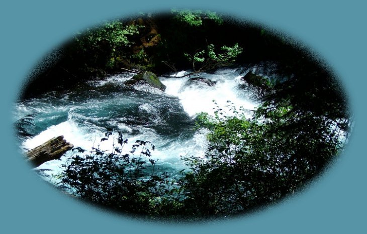
The McKenzie River on the Waterfalls Loop Tour
photographed when walking upstream on the northside of the river.

The West Cascades National Scenic Byway in Oregon follows a path that includes the Cascade Mountains, several rivers, many of them designated wild and scenic, as well as, old growth forests, waterfalls, pristine lakes and lava flows. It offers camping or picnicking hiking fishing and much more. With so much to see an do, you might wonder how to get it all in. Don’t worry, you don’t need to try and make the trip all at once unless you want to, for the tour can be divided into three segments of approximately 75 to 100 miles each, depending on where you connect. If you elect to take the entire drive in one trip, the byway is 225 miles of scenic wonder and beauty.

The tour can be divided into three segments of approximately 75 to 100 miles each, depending on where you connect.
If you elect to take the entire drive in one trip, the byway is 225 miles of scenic wonder and beauty.

Clackamas - Breitenbush Segment

Beginning at Estacada, Oregon: From there begins a 75 mile drive of Nature's wonder on Hwy 224 and Forest Service Road 46. Note: FS Road 46 is closed during the winter.

The scenic byway follows the beautiful Clackamas River flanked by Old Growth Forests. Turn as the river turns, and connect with FS 46 just after Ripplebrook Ranger Station. FS 46 will take you to Detroit on Hwy 22. If you're not in too much of a hurry, you might want to take a slight detour to Bagby Hot Springs. If so, follow FS 46 for 3.5 miles before connecting with FS 63. Follow FS 63 for 3.5 miles until you see FS 70. Follow FS 70 for about 6 miles until you arrive at the trailhead parking. It's an easy 1.5 mile hike to the springs. (Parking is usually congested. There have been other problems as well, but volunteers from the Friends of Bagby Hot Springs work to help keep control of the situation.)

Back on FS 46: Leaving the Clackamas River behind, you'll connect with Breitenbush River. Continue this way into Detroit, Oregon.

If you are taking the tour in segments, the junction with Hwy 22 is a good place to break at this time. If that's your plan, turn west on Hwy 22 and head back to Salem, Oregon. This route follows the north fork of the Santiam River, and has its own charm. You'll end up in Salem with access to I - 5 before entering the city proper.

If you want to spend time in Salem, Hwy 22 turns into Mission Street with easy access to downtown and the historic Mill District.

If not, continue east on Hwy 22, following the north Santiam River in the West Cascades National Scenic Byway.

As a suggestion: You might want to turn off at Marion Forks and follow the creek to the trailhead of Gooch Falls, a popular hike, and perhaps continue on to the trailhead for Marion Falls at the end of the road, as well. I have not yet done this myself. I wanted to last August, but the road, although not bad, was not something I wanted to travel in my trusty old Escort. Especially since it was so late in the season and the water levels would be low. I decided to wait until next year, try the road after it had been graded and before the washboard effect had time to set in. Still, the creek was quite beautiful as I drove alongside.

The McKenzie Santiam Segment

Beginning in Salem, Oregon: Connect with this route in Detroit after traveling east on Hwy 22, the Santiam Pass.

  • The McKenzie - Santiam Segment is 75 miles on Hwy 22 and 126. If you're beginning in Salem, the distance from Salem to Detroit is not included in this accounting.

Beginning in Albany or Sweet Home: Connect with The Western Cascades National Scenic Byway in Sweet Home or Albany on the Over the River and through the Woods Scenic Byway, Hwy 20. This is a beautiful, placid sort of drive. Not one to take if you're in a hurry. There are many hikes along the route, trailheads clearly marked from the road. June and July offer beautiful vistas of wildflowers. The interesting rock formations of the Menagerie wilderness, hiking trails accessible from the road, are also available on this route. No matter your plans, take the time to relax, meandering along the south fork of the Santiam River before connecting with Hwy 126.

  • If you begin in Estacada, you won't drive on Hwy 20 at all.

Follow Hwy 22 until Hwy 126. At this junction you'll have to turn west or east. Turning east will allow for a wonderful deviation from the West Cascades National Scenic Byway. I'll explain this opportunity in time. For now, we'll continue west on Hwy 126.

Continuing west on Hwy 126: The lava flows along here are quite spectacular. Keep your eye out for road signs. It won't be long before you see signs for Clear Lake on the left. Clear Lake is a very beautiful mountain lake fed by underground springs. It's also the source of the McKenzie River. As the name implies, the lake is quite clear. If fishing is intended, you should know that the fish can see you as easily as you can see them.

Soon after Clear Lake, the sign for Sahalie Waterfall appears on the right. Do take the time to stop. The waterfall is easily viewed after a short walk to the edge of the river canyon. If you're looking at Sahalie Waterfall, you're standing on Waterfalls Loop Trail that connects with the McKenzie River National Recreation Trail.

The Waterfalls Loop Trail: a mere 3 miles of splendor. A beautiful, yet short journey of the many and fabulous faces of the McKenzie River near the headwaters. If you cannot make the Waterfalls Loop Tour, spare the few minutes and hike from Sahalie to Koosah Waterfall.

The Hike from Sahalie to Koosah Waterfall: An easy .5 mile if someone in your party elects to drive to Koosah Waterfall and meet you there. If not, you'll have to turn around and walk back, but I tell you in truth, the hike is short, and quite beautiful no matter how many times one has taken it. If time is not an issue, take the truly magnificent Waterfalls Loop Hiking Trail.

If you decide to take the Waterfalls Loop Hiking Trail, I've noticed that most people walk upstream from the waterfalls on the east side of river, that is, the side nearest the parking areas. I think the hike is more beautiful if you walk downstream on the eastside, cross at Carmen Reservoir, and connect with the McKenzie River National Recreation Trail on the west side to walk upstream from there. It's more fun to see each wonder as you approach from this direction. Otherwise, you have to turn around and look where you've been and that's never as nice as watching where you're going. Perhaps I feel this way because I've hiked on the eastern side more times than I can count and have since come to appreciate the diversity.

If you'd rather turn east on 126 and continue until Sisters, Oregon: You just might if you read what follows. You'll know you're in Sisters when you see McDonalds and other such commercial enterprises. You may want to spend some time here. The town has gal-
leries, gift stores, a nice natural foods store called the Harvest Basket on Spruce Street, at least one bakery, gas stations and expected fast food outlets although the McDonalds is relatively new. Traffic can be a problem. What was once a cowboy town has become a haven for tourists, and that's just what the town looks like as you're funneled through a bottleneck - people leaving central Oregon, heading west. People leaving the congestion of the Willamette Valley heading east. Yet, the town is small, and therefore, the bottleneck is also.

At Sisters, unless you want to head into Central Oregon and the High Desert, turn around and head west, this time on the McKenzie Pass - Santiam Pass Scenic Byway, otherwise known as Hwy 242.

The Beautiful and Amazing McKenzie Pass-Santiam
Pass Oregon Scenic Byway

Hwy 242 is not part of the West Cascades National Scenic Byway, but I must at least include the option. Many agree. Indeed, last summer I met a woman from Illinois at Dee Wright Observatory. She'd driven to Oregon to pick up her son who had just finished the year at the University of Oregon in Eugene. She'd found this wonder when she'd brought him out here for the school year and knew she wanted to see it again. On this trip, she missed the turnoff on the western end of the route and was considerably beyond it when she realized what she'd done. Despite her son's dismay, she turned around, drove back and connected with Hwy 242. She wasn't going to miss her pilgrimage to the birth of mountains. I include it now for you.

Hwy 242 begins just west of Sisters. Access 242 when the road forks on the western edge of Sisters. It's clearly marked:

Initially, you'll drive through forests devastated by fire, but that is left behind as you approach the summit. Near the summit the vista changes to rugged, volcanic beauty, as well as, great views of several of the major mountains in the region. Stop and look around. Every view is amazing. Climb to the Dee Wright Observatory, a unique structure built by the Civilian Con-servation Corps in the 1930's and view the various mountain peaks through windows called "lava tubes". The observatory, constructed of stone, blends well with the surround-ing landscape. View Mt Washington, Jefferson, the Three Sisters, Belknap Crater, Black Butte and more. It's even possible to catch a glimpse of Mt Hood in the distance. Track solidified lava flows as they streamed down the flanks of many and different. mountains. If you like, check Recommended sites to see to get an idea of what can be found on the McKenzie Pass - Santiam Pass Oregon Scenic Byway.

Heading down the mountain

As you head west, Hwy 242 will take you on a series of switchback curves down the flanks of the mountain. The route is closed in winter, and usually doesn't open until sometime around the 4th of July. However, its beauty is unmistakable during summer and autumn: wildflowers, the colors of vine maple in autumn, lovely *Proxy Waterfalls reached by a remarkable, yet short, walk through rugged volcanic landscape, and so much more. *The Forest Service charges $5.00 per car, per day for this hike.

On one trip, several years ago, and companion and I found a lovely waterfall alongside the road. It's not marked, but if you're heading west, it will be on your right somewhere after the 58 - 59 mile marker. Look for a meadow on your right with car tracks heading off to the left. There will be evidence of picnic fires. Stop and park, walk on one of the paths that lead into the forest, and you'll come across the waterfall.

The first time I saw this the area was more secluded. Coming across the waterfall was almost as if I'd found something hidden and unknown. The last time I was there the area had been opened up, and that sense of mystery was gone. Regardless, the waterfall is lovely and you might want to stop and check it out.

Once you've made your way down the mountain and connected with Hwy 126 again, head east if you want to complete the loop and view waterfalls, hike along the McKenzie between Koosah and Sahalie, or hike the Waterfalls Loop Tour. If you think you just can't make it this time, save the waterfalls on the headwaters of the McKenzie for later and continue west on Hwy 126 to the turnoff for the "Aufderheide". If you want to save the "Aufderheide" segment, continue into Springfield, Oregon where you can connect with I - 5.

The "Aufderheide", a one time national forest scenic byway until incorporated into the West Cascades National Scenic Byway:

Continue west on 126 until you see the sign for Cougar Recreation Area and FS 19. Turn left on FS 19. This is the "Aufderheide". If somehow you miss the turnoff, you'll see the signs for the town of Blue River on Hwy 126 and know you've gone too far west. Turn around and drive east for about 4 miles and turn right on FS 19. Note: Like FS 46, FS 19 is closed during winter.

The "Aufderheide"

The "Aufderheide" Segment is 70 miles on Forest Service Road 19 and offers much to see and do.

Initially, the road follows the south fork of the McKenzie River, skirts the western flank of the 3 Sisters Wilderness Area, travels through Old Growth Forests, alongside Roaring River and finally, the wild and scenic North Fork of the Middle Fork of the Willamette River. You'll find Cougar Recreation for boating and fishing, hiking trails galore, old giants in the forests, Terwilliger Hot Springs (otherwise known as Cougar Hot Springs), camping, swimming, boating, fishing, water skiing, picnicking; certainly sightseeing.

Travel but .25 of a mile on FS 19 and you'll come across Delta Campground and Delta Nature Trail *, a wheelchair accessible hike, or walk. Drive into the campground, find the trailhead and begin hiking right away. Right there, almost immediately, you have it all: a lovely hiking trail, old growth forests of Douglas Fir and Western Red Cedar, secluded campsites nestled in the lush vegetation of a campground situated on the McKenzie River and more.

You may want to stop at Terwilliger Hot Springs near Cougar Recreation. Terwilliger Hot Springs is beautiful, 6 pools descending the mountain flank. It's also very popular, hence the Use Fees: $5.00 per person. Pay at the tollbooth at the trailhead.

Continue along the south fork of the wild and scenic McKenzie River; as it tumbles over rocks and boulders, forging its way through stands of old growth forests. Skirt the western edge of the Three Sisters Wilderness Area after Cougar Recreation. Hiking trails and trailheads are marked, you can stop to walk and "meditate" in the serene peace only a forest can give. Delta Old Growth Trail, as stated previously, is the first hiking trail you'll come to. French Pete Trail is next. Follow French Pete Creek for 3 miles, hiking into the Three Sisters Wilderness Area.

Campgrounds are scattered along this route. More than one in the Cougar Recreation Area. There are many others as you head southwest along the south fork of the McKenzie River, traveling through old growth forests and later along the wild and scenic north fork of the middle fork of the Willamette River. I get ahead of myself here, we've yet to leave the McKenzie.

Leaving the McKenzie behind, travel through palisades of old growth forests along the beautiful Roaring River. Even though small, the river is magnificent: tumbling, even "roaring" waters of icy blue, reminiscent of the North McKenzie at the waterfalls.

The Roaring River fades into memory, replaced by very present majesty of the magnificent wild and scenic north fork of the middle fork of the Willamette River. If you arrive early enough in the season, you'll find several great swim-ming holes along this segment of the route. Regardless, the river provides splendid viewing and a great drive.

The West Cascades National Scenic Byway ends in Westfir, Oregon. Westfir is a quite small, yet picturesque, community replete with covered bridge and great blackberry brambles drenched in berries from August through October.

Continue out of town to the Willamette Pass, Hwy 58, just west of Oakridge. Head west on 58 to connect with I - 5. Or travel east for another journey replete with scenic wonder, hiking trails, mountain lakes, and beautiful Salt Creek Waterfalls.

  • *Delta Nature Trail: Wheelchair accessible, this loop trail has three bridges that cross streams and channels flowing into the river proper. A hiking brochure is available at the parking area that sights several points of interest for hikers. Some of the trees are 650 years old, towering to heights of over 200 feet. Sadly, it may have burned in the Holiday Fire of 2020.

  • Delta Campground: Apart from what was stated above, the camping facilities: fire rings, water delivered by hand pumps, vault toilets, garbage service, amphitheater, wastewater disposal sites, an interpretive nature trail and tables.

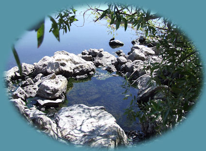
Forward ~ West Cascades National Scenic Byway, Map, the northern section, page 1.

Back ~ Scenic sites on the West Cascades National Scenic Byway.

USFS: The Willamette National Forest
USFS: Deschutes Ochoco National Forest

The West Cascades National Scenic Byway, 220 miles of unparalleled beauty, one vista after another: the Cascade Mountains, hiking trails, waterfalls, mountain lakes, old growth forests, spectacular lava flows, volcanoes, wilderness areas ... Map, page 1 and page 2, and Scenery.

Koosah Waterfalls, on the McKenzie River National Recreation Trail, pictured to the right.

Sahalie Waterfall on the wild and scenic mckenzie river, hiking the waterfalls loop tour on the mckenzie river national recreation trail.

If you want to continue on Oregon Hwy 58, or the Willamette Pass

Travel Directions, Map & Scenery

Or an alternative to the Willamette Pass, Hwy 58

Brad calls it the Crescent Oakridge Inback Loop: Travel Directions. See the map for the Willamette Pass above.

Travel Oregon and northern California while staying at Gathering Light ... a retreat located
near Crater Lake in the Klamath Basin of Oregon.

Travel to the retreat on the West Cascades National Scenic Byway: Directions, Map & Scenery and the Willamette Pass, Hwy 58: Directions, Map & Scenery.

Travel Directions to and Day Trips of about 100 miles from the retreat.

Little known Scenic Places with opportunities to explore nature untrammeled: hiking, sightseeing, wildlife viewing, birding, & more, near the retreat and Crater Lake: Travel Directions, Map and Scenery.

Website Directory for the travel pages      Home Page

Page Listings to the travel pages

Cabins on the river at gathering light ... a retreat in southern oregon near crater lake national park: cabins, treehouses on the river in the forest.

Contact Brad at Gathering Light ... a retreat

Eagle Ridge, one of the many birding trails near the retreat, pictured above.