Hiking Trails on the McKenzie Pass - Santiam
| |
| |
... Mt Washington & the Yapooah Crater Lava FlowsHwy 242, or the Santiam Pass - Mckenzie Pass Oregon Scenic Byway, is closed during with winter. Check with the USFS Willamette National Forest to make certain when it opens. Oftentimes, fire in the forest impedes vision later in the summer, so plan for this as well. There are many hiking trails to access on the Santiam Pass - McKenzie Pass Oregon Scenic Byway, hwy 242, accessed 2 miles after the Ranger Station on hwy 126, the McKenzie Pass. Some are hiking trails easy and some more difficult. I'm listing just a few here. Water must either be brought in or treated. Some of the trails offer a vault toilet. Proxy Falls for one. Most don't. Proxy Waterfalls TrailheadHeading west to the summit, access the trailhead to Proxy Falls 10 miles after the turnoff from hwy 126, the McKenzie Pass. Located in the Three Sisters Wilderness area, this one way loop hiking trail travels through open lava fields - I thought the rock formations interesting, and dense forest. It offers two lovely, yet distinctly different, waterfalls. The hiking trail is very popular, so be sure to follow the route as signed to avoid congestion. The Willamette National Forest rates this trail as easy with some steep approaches the for the first half mile. A Northwest Forest Pass is required. Parking is available on both sides of hwy 242. Linton Lake TrailheadTo find the hiking trail to Linton Lake: Drive about 11 miles east from the turnoff on 126, the McKenzie Pass. The hike is 1.5 miles one way and located in the Three Sisters Wilderness area. A view of Linton Waterfalls is offered from the hiking trails. The forest service rates this trail as easy to moderate. It's a popular hiking trail and parking is limited, so plan ahead. A Northwest Forest Pass is required, as well as a Wilderness Self Issue Permit. Obsidian Cliffs TrailheadTo find the hiking trail to the Obsidian Cliffs in the Three Sisters Wilderness area, drive 16.7 miles from the turnoff with hwy 126, the McKenzie Pass to the Obsidian Trailhead. The trailhead is clearly marked. The trail is 4.2 miles. It begins at an elevation of 4800 and ends at 6000 feet. It's one of the more popular hiking trails. It accesses the Three Sisters Wilderness Area, as well as the Pacific Crest Trail. The Willamette National Forest rates this trail as difficult. A Northwest Forest Pass is required, as well as a Limited Area Permit. Limited Area permits for this hike can be obtained at the McKenzie Ranger Station for the Willamette National Forest or the Sisters Ranger Station for the Deschutes National Forest. Permits must be acquired at least 30 days before your planned hike. To find out more about Limited Entry Permits: Contact the USFS Willamette National Forest. Scott Mountain TrailDrive about 17 miles after the turnoff from hwy 126, the McKenzie Pass, to the Scott Lake Road. Follow the road until the end, find the trailhead to the Benson Lake hiking trail. Hike about 3 miles to connect with the Scott Mountain hiking trail, which is one mile only. This trail is in the Mt Washington Wilderness Area and climbs 600 feet in one mile. Offering stupendous views of the Cascade Mountains. A Northwest Forest Pass is required, as well as a Wilderness Self Issue Permit. Lava River National Recreation TrailDrive about 20 miles from the turnoff on hwy 126. You'll know you're there when you see it. The view will look like the one pictured on this page. The hike is .5 mile. It's paved, offering remarkable views of the lava flows from Yapooah Crater. The path is marked by interpretative signs. Access the trail just east of Dee Wright Observatory at the summit. No permits required. Contact the USFS to obtain an Annual Northwest Forest Pass. Other recreation passes available from the USFS. | |
|
Forward ~ Travel Directions on the Aufderheide on the West Cascades National Scenic Byway. Back ~ Campgrounds on Oregon Hwy 126, the McKenzie Pass, on the West Cascades National Scenic Byway. USFS: Willamette National Forest. Travel the West Cascades National Scenic Byway: Directions, Map & Scenery: lava flows, mountains, wildflowers, old growth forests, wild & scenic rivers, waterfalls, hiking trails, hot springs, mountain lakes, campgrounds. Or, perhaps &, the Willamette Pass: Directions, Map & Scenery, & the Crescent Lake, Oakridge "Inback" Tour: Directions & Map. |
|
|
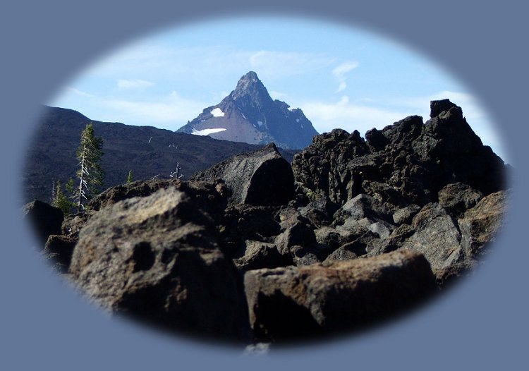
Mt Jefferson viewed from the summit on the Santiam Pass - McKenzie Pass Oregon Scenic Byway, pictured above. Travel Oregon and northern California while staying at Gathering Light ... a retreat | |
|
Travel to the retreat on the West Cascades National Scenic Byway: Directions, Map & Scenery: hiking, waterfalls, wild & scenic rivers, mountains, volcanoes, hot springs, wilderness, scenic byways. Or, perhaps &, the Willamette Pass: Directions, Map & Scenery. Travel Directions to and Day Trips of about 100 miles from the retreat. Scenic Places: hiking, wetlands, wildlife refuges, river gorges, mountains, wilderness, wildlife viewing near Crater Lake & the retreat: Directions Map & Scenery. Website Directory for the travel pages Home Page |
|
|
Mt Scott, on the easter flank of Mt Mazama, Crater Lake, viewed from Wood River Wetlands one of the many Klamath Basin birding trails near to Crater Lake National Park and the retreat. Contact Brad at Gathering Light ... a retreat. | |