Traveling the Willamette Pass in the Cascade Mountains of Oregon. | |||||
|
Forward ~ Crescent Lake "Inback" Tour. Back ~ The Aufderheide on the West Cascades National Scenic Byway. USFS: The Willamette National Forest Brad and I invite you to explore the Willamette Pass and Enjoy Oregon! Travel Map and Scenery. |
||||
|
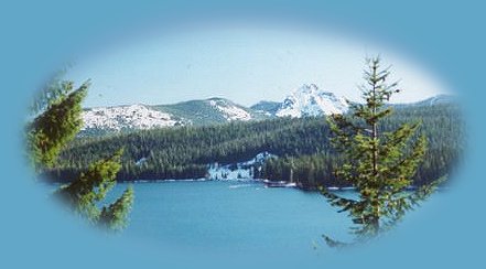
Diamond Peak and Odell Lake on the Willamette Pass. | |||||
|
Our Getaways offer written Directions, Maps and suggested scenery, spanning Oregon and northern California; places Brad and I have visited and loved. These getaways offer simplicity, yet beauty in scenery, waterfalls, hiking trails, campgrounds, mountains, hot springs, mountain lakes, equestrian trails, mountain biking trails, wild and scenic rivers, scenic byways, Crater Lake National Park, national monuments & more. Protect our National Forests and Wilderness Areas. Leave NO Trace! | |||||
|
Beginning in the Willamette Valley: Access Hwy 58, or the Willamette Pass, as it's also known, on I - 5 just south of Eugene. The sign says Klamath Falls. That's the exit to take. Driving east, past Pleasant Hill, along Lookout Point Reservoir, watch for trailhead signs on the right, there's a lovely and quite easy hike along a small creek with a graceful waterfall a short distance into the forest. The trail does continue after the waterfall if you care to see where it goes; I have not done this myself. Black Canyon Forest Service Campground is on this stretch of the road. Shady Dell too, but one must have reservations for this this campground. Much of the more exceptional scenery waits to begin after Oakridge, Oregon, at the 31 mile marker. One can, however, access the Auferderheide just before Oakridge for beautiful views of the north fork of the Willamette River, swimming holes, old growth forests if that's a preference. For this journey, if you want to continue on the Willamette Pass, continue into Oakridge. The town offers Greensprings, a rest/park/picnic area situated along the Willamette River. A stop here gives a nice break if you've been driving awhile. Find it on your right at the east boundary of town, stop, picnic, cross the bridge over the Willamette River and hike back into the forest ... Right after Oakridge, another option rather than the Willamette Pass is available, check it out if you're interested. If you decide to continue on the Willamette Pass:
Hwy 58 offers a couple of alternatives on the eastern side of the mountains. If you choose, just continue on until it connects with Hwy 97. Hwy 97 travels north south, paralleling I-5. Surprising though it may seem, crossing the Cascade Mountains from the Willamette Valley and traveling south on Hwy 97 is shorter than taking I - 5 to California. For that reason many truckers use the road winter and summer. I'll leave it to you to decide which you'd rather take if you're heading into northern California. Hwy 97 does offer some spectacular views of the mountains, Mt Thielsen just south of Chemult, Mt Scott, which forms the eastern rim of Crater Lake south of that. Hwy 97 also offers easy access to other scenic points: Christmas Valley, Fort Rock, Silver Lake, Summer Lake and hot springs ... and the views of the Cascade Mountains along Klamath Lake are magnificent. Overall, I'd say that other routes are more beautiful than Hwy 97, however. The other alternative Hwy 58 offers is the Cascade Lakes Highway. Turn east off Hwy 58 when you see the sign for Crescent Lake (the town, not the lake - this is further east beyond Crescent Lake junction.) When you see the sign for Crescent Lake, turn and head east until you see the sign for the Cascade Lakes Hwy. Find, many mountain lakes, campgrounds, fishing, reservoirs, mountains, scenery ... The road will eventually connect with what used to be called Century Drive. I looked last summer and the signs I saw still said Century Drive. As I understand it, however, the road is now supposed to be known as the Cascade Lakes Hwy all the way into Bend. Mt Bachelor is easily viewed and accessed from this part of the highway. Keep traveling, and you'll come out in Bend. Obviously, any choice you might make will depend on where you want to go ... :-) | |||||
|
Travel Oregon and northern California while staying at Gathering Light ... a retreat | |||||
| |||||
|
Cormorant in the tree at Wood River Wetlands, one of the birding trails not far from Crater Lake National Park and the retreat. | |||||