Salt Creek Falls Hiking Map
Hikes in the willamette national forest in oregon: hiking trails to waterfalls at salt creek waterfalls picnic day use area on the willamette pass in the in the diamond peak wilderness of the cascade mountains in oregon: see diamond creek waterfalls, fall creek waterfalls and mountain lakes.

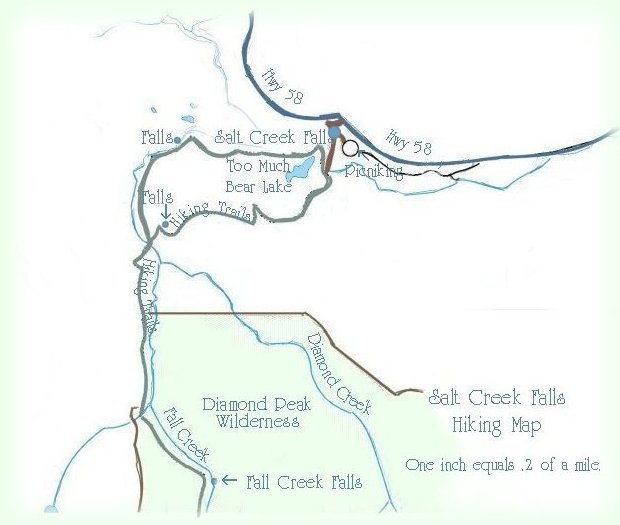
Diamond Peak Wilderness Area

Forward ~ Map of Hwy 58, the Wil- lamette Pass & Hwy 138, the Rogue Ump- qua Scenic Byway.

Back ~ Scenery on the Willamette Pass, or hwy 58.

USFS: The Willamette National Forest.

The Day Use Area at Salt Creek Falls is a Fee Use Area: $5.00 per car; the loop trail does not include Vivien Lake and Fall Creek Waterfalls. It is 3.3 miles.

Happily, Brad and I present the Travel Directions, Map and Scenery on the Willamette Pass through the Cascade Mountains of Oregon.

Travel Oregon and northern California while staying at Gathering Light ... a retreat
near Crater Lake National Park in southern Oregon.

cabins on the river at gathering light ... a retreat located in southern oregon near crater lake national park: cabins, tree houses on the river in the forest.

Travel to the retreat on the Willamette Pass, Hwy 58: Travel Directions, Map and Scenery: waterfalls, hiking trails, snow mobiling, snow boarding, mountains lakes, skiing, cross country skiing, mountain lakes, campgrounds and more.

Directions to and Day Trips of around 100 miles the retreat.

Little known Scenic Places, opportunities to photograph untrammeled nature: hiking, sightseeing, wildlife viewing, birding, and more, all near the retreat and Crater Lake: Directions Map and Scenery.

Website Directory for the travel pages      Home Page

Page Listings to the travel pages

Contact Brad at Gathering Light ... a retreat.