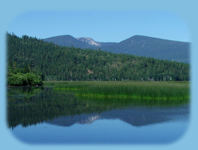
Mountain Lakes Wilderness in the Fremont Winema National Forest of Oregon
Geology of the mountain caldera
that forms the hollow for several small mountain lakes
Mountain Lakes wilderness possesses a geologic history similar to that of Mt Mazama, the caldera that forms Crater Lake National Park. Like Crater Lake,
the mountain hollow is a large caldera that was formed by cataclysmic eruptions and the ultimate collapse of a volcanic cone. Mountain Lakes wilderness is not like Crater lake in that the caldera is filled with several smaller lakes, not just one.
Several million years ago a series of volcanic eruptions began that built a massive stratovolcano. Mt Jefferson, north of Crater Lake in the Cascade Range is an example of a stratovolcano: a mountain composed of several different "peaks". The caldera of Mt Mazama was formed with the sponaneous eruption of first one then another of the several volcanic "peaks" that formed a mountain over 12,000 feet high, the several peaks that in the end came to be the caldera of the mountain lake wilderness formed a mountain that at one time stood over 12,000 feet high with a base that covered about 85 square miles. As with Mt Mazama, the same forces that built this great volcano destroyed it.
Today, eight prominent peaks are all that remain of the original rim. With the advent of the "ice age" repeated glaciations shaped the land, carving beds that now contain the many small lakes, each possessing a unique personality and ecological setting.
Hiking trails associated with the Mountain Lakes Wilderness*:
The Mountain Lakes Loop hiking trail
The Mountain Lakes Loop hiking trail is 8.2 miles long. It begins at Varney Creek hiking trail 3718 and ends at Varney Creek hiking trail 3718. The trail is open for the following uses: Hiking, Horseback Riding.
Though the above information, which I gathered from the USFS Fremont Winema National Forest website, the Mountain Lakes Loop hiking trail can be accessed from the Varney Creek hiking trail, as well as Clover Creek hiking trail and the Mountain Lakes hiking trail.
Brad and I have never done the Mountain Lakes Loop Hiking Trail in its entirety. We've hiked on Varney trail to connect with the Mountain Loops Hiking Trail and then walked to two lakes on the loop before turning around and walking back to the trailhead. This brings up an important point, for though the Mountain Lakes Loop hiking trail is 8.2 miles, one must first hike up another trail to connect with it. As I said, Brad and I took the Varney Creek Trail.
Varney Creek hiking trail, one of 3 trails that leads to the Mountain Lakes Loops hiking trail
The Varney Creek trail is 4.4 miles long. It begins at Trailhead End Of Road 3664 and ends at Mt Lakes Loop 3727. The trail is open for the following uses: Hiking, Horseback Riding.
I can give a good idea of where to access this trail even though the website is totally bereft of this information. Whether heading east of west on Oregon Hwy 140, the Volcanic Legacy Scenic Byway, you will find the signs for the trailhead in the valley between the high Cascades on the west and Doak Mountain on the east. If you're coming from the west, Medford, Oregon or thereabouts, the trailhead will be on the right soon after you descend into the valley. It is clearly marked. If you are heading east from Klamath Falls, Oregon, the trailhead is beyond the turnoff for Crater Lake National Park - Rocky Point around mile marker 43. Continue heading west when you see these signs, and soon after, before the ascent begins the ascent into the high Cascades, you'll see the sign for the turnoff. Turn left. I can't say how far you have to drive after the turnoff. This is one of the first hikes Brad and I ever did after I moved down here, and what we did to get to the trailhead is lost to me in all the newness of all that I was experiencing then.
The Mountain Lakes hiking trail, one of 3 hiking trails that leads into the Mountain Lakes wilderness of the Fremont Winema National Forest
The Mountain Lakes trail is 6.3 miles long. It begins at Rainbow Bay Picnic Area** and ends at the Mountain Lakes Loop hiking trail 3727. The trail is open for the following uses: Hiking, Horseback Riding.
**I believe that Rainbow Bay Picnic Area can be accessed at Lake of the Woods near the summit of Oregon Hwy 140, at the turnoff for Dead Indian Memorial Road.
Clover Leaf hiking trail, one of 3 trails that connects with the Mountain Lakes Loop hiking trail in the Mountain Lakes wilderness
The Clover Creek trail is 4.3 miles long. It begins at Trailhead At Road 3852 and ends at Mountain Lakes Loop hiking trail 3727. The trail is open for the following uses: Hiking, Horseback Riding.
I can't say anymore about the Clover Creek hiking trail than what I've posted above. When I find out more, I will update the information in this site.
To find out more by phone contact the Klamath Ranger station of the Fremont Winema National Forest at 541-
*I apologize for the paucity of information associated with these hikes. The USFS in it ultimate wisdom decided to revamp all the websites for the national forests, and whomever is designing the sites, replaced perfectly serviceable websites with sites that are either not complete or even worse, have information with links that have absolutely nothing to do with the area they're describing. Last winter I called about a supposed hike on the Applegate River in the Rogue River Siskiyou National Forest that was actually on the Rogue River. I checked today, and that information still stands. I use these sites all the time to find specific information that pertains to hikes Brad and I have done. I am disgusted. I don't understand why they just didn't wait until the new sites were perfected before they were uploaded. That's what I do. As the sites are improved, I will upgrade my information as well. :-)
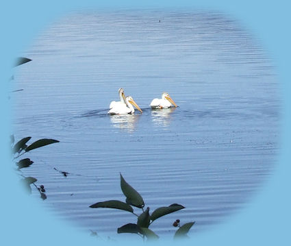
Klamath Basin in the Pacific Flyway, a birder's paradise
Easily accessible and quite marvelous birding sites: The Upper and Lower Klamath Wildlife Refuges, Tulelake Wildlife Refuge, Wood River Wetlands on Agency Lake, Howards Bay and Shoalwater Bay - Eagle Ridge on Klamath Lake.
There are more! Check them out: Birding Trails in Klamath Basin and the Pacific Flyway.
Preserve Natural Beauty: wildlife refuges, our national forests and wilderness
areas. Leave NO Trace! Be sure to check out fire conditions at the Ranger Station before
traveling, hiking or camping in the forest.
|