|
Brad and I are happy to share the Surprise Valley Warner Mountain Outback Tour with you: Travel Directions, Map and Scenery: the austere beauty of northeastern California, mountains, hot springs, wildlife viewing, south Warner Wilderness Area, hiking trails, equestrian trails and more.
Our Getaways offer written Directions, Maps and suggested scenery, spanning Oregon and northern California; places Brad and I have visited and loved. These getaways offer simplicity, yet beauty in scenery, waterfalls, hiking trails, campgrounds, mountains, hot springs, mountain lakes, equestrian trails, mountain biking trails, wild and scenic rivers, scenic byways, Crater Lake National Park, national monuments, wildlife viewing & more.
Protect our National Forests and Wilderness Areas. Leave NO Trace!
Be sure to check out fire conditions at the Ranger Station before traveling,
hiking or camping in the forest.
|
The Surprise Valley, Warner Mountain Outback
Tour in northern California
If you've dreamed of touring renowned and majestic Steens Mountains, but find their isolation and accessibility too time consuming or otherwise problematic, you'll find the Warner Mountains and surrounding area in northeastern California a worthwhile alternative, offering little traveled mountain passes, hot springs, big sky & vistas almost surreal in peace, grace and serenity. A must if you want to unwind, leave the common and congestion behind and step into another era with all the rustic trimmings, simplicity and relaxing ambience of the genuine old west without the usual commercial facade. - bk
I started these directions at Lakeview, then thought it might be helpful to give a little more information. Not knowing where one might begin I will assume a starting point from Klamath Falls. If that's the case, take Hwy 140 east until Lakeview, Oregon. From Lakeview head south on Hwy 395. It's the first blinking light you'll encounter if you've arrived in Lakeview by Hwy 140.. You may want to drive around & view some of the old western buildings, etc. If so, just turn left on any of the side streets after Safeway. When you're ready to leave Lakeview get back on 395 & head south. You'll smell the mineral springs; Goose Lake is on your right.
To see a gallery of photographs of different places mentioned in the description below, check this out.
Hwy 395 offers four passes over the Warner Mountains into Surprise Valley. You'll come across two of the more rugged passes not long after you cross the California Border.
Highgrade Road ~ This is the first pass you'll come to. It's at New Pine Creek. On this pass you'll find two small lakes, Lily & Cave, and abandoned mines. Highgrade Rd will bring you down into the north end of Fort Bidwell. You'll drive by the old
pioneer house pictured in the website.
Fandango Pass ~ The second route shown on your map. It's of better quality than Highgrade Rd. & if miles are a consideration, it's shorter. Also, the view of Surprise Valley from the summit is unsurpassed. This route comes down south of Fort Bidwell, so if you want to experience this little gem, turn left, or north, when you come down into the valley.
When you get into Ft Bidwell, which has a very relaxed atmosphere, just experiment & look around. The church is on the main drive; you'll probably want to make inroads into the town, for that's the way to truly experience this step out of time.
Some distance south, but before Lake City, you'll see evidence of nature's fury. In 1996 & 1997 it rained & it flooded. In 1997 the mountain spilled into the valley. We were there the summer of 1997. The road was washed out . Although this area is fenced off now, then we were able to walk in the catastrophe. Everywhere we looked we saw evidence of a great cataclysm that altered life for all time. Trees torn up by the roots now laying peacefully. Boulders the size of bungalows moved about as if they were Styrofoam. A house, still standing but uninhabitable, surrounded by debris from the avalanche & that includes tons of dirt ~ at that time it was mud.
In this vicinity you'll see the grand old house with deer eating in the front yard that's pictured in the website. It's on the right when you're heading south. Drive through Lake City if you like, for there are interesting homespun, antique features: an old gas station, what appears to be an old hotel now being refurbished .... When you've seen all you want continue south to
Cedarville, as all the towns, north & south, are nice "hangouts" if you want to soak up the vintage architecture & relaxing ambience.
Cedarville ~ There are hot springs east of Cedarville. Although it's a motel you can soak even if you don't want to spend the night. The tubs, private, are outside; the expansive desert sky overhead & mountain vistas to the east. Turn east at the 4-way stop in Cedarville & drive about 5 miles. It's on the right.
Back in Cedarville, head south again. You'll come to
Eagleville, another town of unpretentious character. The South Warner Wilderness is further south where the exploring soul can hike & camp. Further south, the
mountains begin to diminish. You can go to Nevada by this route.
You have your choice of two other passes out of the valley. A forest service road will take you over the mountains just south of Cedarville. Snowdrifts can be a problem into the summer. Unless you don't want to turn around it's best to check with a reliable local source if you want to take either Highgrade Rd. the most northerly route, or this, the most southerly. Cedar Pass on Hwy 299 has been open anytime we've headed over this way. It is closed on occasion in the winter.
Whether you choose Cedar Pass or the forest service road mentioned above, both will bring you down on the west side to connect with Alturas. Alturas has some interesting buildings, the courthouse for one. If you have time, you might want to visit the wildlife refuge viewing area on the southern boundary.
When you leave Alturas head west on 299. You'll come to Canby and not long after you'll see the turn off to Klamath Falls, Hwy 139. Turn right, or north; this will bring you back into Oregon. Hwy 139 is largely uneventful until you get into Tulelake just south of the Oregon border. There you can view the Lava Beds, and/or Tule Lake National Wildlife Refuge, as well as,
Tule Lake National Monument, which includes the Tulelake National Segregation Center, Camp Tule Lake, which was a CCC camp, another site set aside to detain Japanese Americans and finally a prisoner of war camp. If you do decide to do this, you'll probably need to spend at least one night if not more.
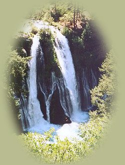
If you have more time, or if you live in California & are heading home by this route, stay on 299. The drive is long, but you'll see some pretty scenery, as well as vintage towns. There's a splendid view of Mt Shasta & Lassen when you come down Aden Pass. Fall River Mills is a nice old town. A vista point west of town offers a spectacular view of Fall River, the gorge & a lovely waterfall. When you get to Hwy 89 turn north, visit McArthur Burney Falls ... 89 will take you into McCloud where you can connect with I-5 if you want a more direct route south. Wild Larkspur bloom everywhere in late June & early July. Lassen National Park is in this area.
If you don't want to take 89 into McCloud, get back on 299 & take it into Redding.
If your choice is 89, & you want to head north, you can choose between 97 at Weed to take you back to Klamath Falls, Oregon, or I - 5 to take you north to Ashland, Oregon. If your preference is Ashland, & you like the less traveled routes, get off I-5 at Yreka. It doesn't matter which exit, just exit & drive under the freeway. You'll come to a traffic signal where you have to turn north or south. This is 99, turn right & head north out of town. After you leave Yreka, you'll follow Shasta River until 99 connects with I-5. This is a spectacular route, the river, the mountains & the gorge. A wonderful old bridge crosses the gorge; you can pull off for a less cursory view if you're interested. All too soon you'll have to get back on I-5. Follow it north to Ashland/Medford or beyond.
|