|
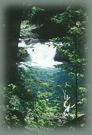
Waterfalls on the South Umpqua River. | |||||
|
Forward ~ South Umpqua Waterfalls Back ~ Mt McLoughlin from Dead Indian Memorial Road. USFS: Hiking trails, waterfalls, campgrounds, rafting, and more, on the Umpqua River, The Umpqua National Forest. BLM: Roseburg District of the Bureau of Land Management. North Umpqua Waterfall Tour: Travel Directions, Map, Scenery; the Diverse Loop Tour: Travel Directions, Map and Scenery - both include Crater Lake National Park: Introduction, include sightseeing, hiking; mountain biking trails, wild and scenic rivers, waterfalls, mountains and more. Combine the two tours and the South Umpqua River Waterfalls. Protect our National Forests and Wilderness Areas. Waterfalls and Hiking, Mountain Biking and Horseback Riding | ||||
|
Campbell Waterfall is a pretty little fall, plunging 15 feet into a beautiful emerald green pool on the South Umpqua River. The trail is a mere 0.3 of a mile, but it's rated more difficult by the US Forest Service. I don't remember anything difficult about this trail other than the fact that there was a lot of poison oak. Nevertheless, Brad and I thought the hiking trail worth taking. :) When we climbed up and out, we washed our exposed skin and any clothing that might have come in contact with the poison oak in Boulder Creek and had no unpleasant after effects from the hike. :) The area around the South Umpqua River is beautiful, and I will repeat what I've said elsewhere, the up river the South Umpqua has a beautiful gorge. The well-marked drive on Forest Service Roads to the Umpqua Scenic Byway, Hwy 138, is worth driving. - gm Also the area around Boulder Creek makes Boulder Creek Campground a very nice camping facility for tents and small campers. It's also nice located for exploring the area around the south Umpqua River. Bring your own water. :) Travel Directions and information for the hiking trails of the South Umpqua River Waterfalls. | |||||
|
|
Links to the retreat only open a new window. Travel to Gathering Light on the Umpqua Scenic Byway: Travel Directions, Map and Scenery: hiking trails, waterfalls, mountains, sightseeing and more. Directions to and Day Trips of about 100 miles from the retreat. Little known Scenic Places, opportunities to photograph untrammeled nature: hiking, sightseeing, wildlife viewing, birding, and more, all near to the retreat: Travel Directions Map and Scenery. |
||||
|
Contact Brad at Gathering Light ... a retreat. | |||||
|
| |||||