The McKenzie River National Recreation Trail
|
|
The McKenzie River National Recreation Trail
is included on the West Cascades National Scenic Byway in Oregon
Most of the wild and scenic McKenzie River is in the Willamette National Forest. Oregon State Hwy 126, or the McKenzie Pass, begins in Florence, Oregon on the coast and ends at Sisters, Oregon in the central Oregon High Desert. The McKenzie River National Recreation Trail begins east of Springfield, Oregon and ends at Clear Lake, the headwaters of the McKenzie River.
|
| |
The McKenzie River National Recreation Trail
The McKenzie River National Recreation Trail is 26.5 miles long and available to hikers and mountain bikers. This is a very popular trail, expect heavy usage near Paradise Campground, Clear Lake Loop and Waterfalls Loop Hiking Trails. Bicyclists dismount on the Waterfalls Loop Hiking Trail or stay on the McKenzie River National Recreation Trail as an alternative.
The hiking trail is rated moderate, spanning an elevation of 1450' to 3200'. The trail is accessible from spring to fall. Drinking water is available at the campgrounds along the way; all other water must be treated.
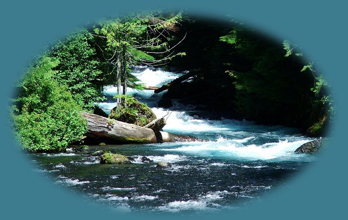
Travel Directions: Traveling on Hwy 126, or the McKenzie Pass, travel west one mile from the McKenzie River Ranger Station to the trailhead. However, several access points are available along the entire hiking trail. Indeed, the above photograph was taken walking along the river, near Deer Creek. We drove across the bridge, parked and started walking on the trail.
The McKenzie River National Recreation Trail closely follows the McKenzie River, a scenic whitewater river originating high in the Cascade Mountains of Oregon. The trail crosses over several tributaries of the McKenzie via log bridges. The lower section passes through Old Growth Forests of Douglas Fir as old as 600 years. The upper portion travels alongside beautiful waterfalls and spectacular lava flows.
No passes required. -
Waterfalls Loop Trail
The Watefalls Loop Trail is 3 miles long, and is available to hikers and mountain bikers. However, bicyclists must dismount when traveling the distance between Koosah and Sahalie Waterfalls on the eastern side of the loop. This is a very popular trail, so be prepared. :-)
The hiking trail is rated moderate, is at an elevation of 2800' and is available spring to autumn. Drinking water is available at Ice Cap Campground, which can be accessed from the parking lot at Koosah Waterfall.
Travel Directions: Travel east on Hwy 126, the McKenzie Pass, 15.5 miles to Carmen Diversion Reservoir. The Waterfalls Loop Trail can also be accessed at both Koosah Waterfall and Sahalie Waterfall.
This hiking trail is part of the McKenzie River National Recreation Trail. If you only have time to do part of it, by all means, don't miss this, or at least the segment between Koosah and Sahalie.. Even though it's rated moderate; it's pretty easy. Although it's definitely easier if you go upstream from Carmen Reservoir, cross the river above Sahalie Waterfall and travel downstream on the other side. The first time I did this hike, I did just the opposite, and was very happy to be traveling upstream on that side of the river. I have chosen to do it that way again. Overall, the only problem might be the tree routes and embedded stones on the trail.
No passes required.
Clear Lake Loop Trail
The Clear Lake Loop Hiking Trail is 5 miles long and available to hikers and mountain bikers. The west side of the trail has periodic closures to protect nesting Bald Eagles so check at the ranger station when making your plans.
Like the others on the McKenzie River National Recreation Trail, this hiking trail has a moderate rating. It's an elevation of 3000' and is available spring to autumn. Drinking water is available at the Cold Water Cove Campground and Clear Lake Resort.
Travel Directions: From McKenzie River Ranger Station travel east on Hwy 126, the McKenzie Pass, 17.5 miles to Clear Lake Resort. Access the trail from the Day Use Area, Clear Lake Resort or Coldwater Cove Campground.
The Clear Lake Loop Hiking Trail circles Clear Lake, passing the headwaters of the McKenzie River and traverses an old lava flow. An interpretive brochure is available at the McKenzie River Ranger Station, Clear Lake Resort and the Coldwater Cove Boat Launch.
No passes required.
|
|
Protect our National Forest and Wilderness Areas. Leave NO Trace!
Be sure to check out fire conditions at the Ranger Station before traveling,
hiking or camping in the forest.
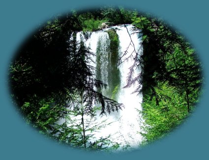
Koosah Waterfall on the Mckenzie River National Recreation Trail pictured below.
|
|
Forward ~ Campgrounds on Oregon
Hwy 126, the McKenzie Pass, on the West Cascades National Scenic Byway.
Back ~ Scenery on the Santiam Pass - McKenzie Pass Oregon Scenic Byway.
USFS: The Willamette National Forest.
The West Cascades National Scenic Byway, 220 miles of unparalleled beauty, one vista after another: the Cascade Mountains, hiking trails, waterfalls, mountain lakes, old growth forests, spectacular lava flows, volcanoes, wilderness areas and more: Travel Directions, Map, page 2, and Scenery.
| |
|
Travel Oregon and northern California while staying at Gathering Light ... a retreat
located in southern Oregon near Crater Lake National Park.
|
|
Travel the West Cascades National Scenic Byway to the retreat: Directions, Map & Scenery & the Willamette Pass, Hwy 58: Directions, Map & Scenery. Enjoy volcanoes, hiking trails, waterfalls, the wild & scenic north fork of the Middle Willamette, the McKenzie & Clackamas Rivers, old growth forests, nature trails, hot springs, Cougar Recreation Area ...
Directions to and Day Trips of about 100 miles from the retreat.
Little known Scenic Places near Crater Lake & the retreat: hiking, sightseeing, wildlife viewing, birding, and more: Directions, Map and Scenery.
Website Directory for the travel pages Home Page
Page Listings to the travel pages
| |
|
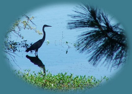
Wood River Wetlands depicted above, one of the many birding trails not far from the retreat.
Contact Brad at Gathering Light ... a retreat.
|