Early morning light
| |
| |
|
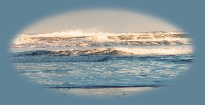
For the Wanderer ... A river path to the Oregon Coast, The Alsea River offers a leisurely route through farmlands, forest and along a graceful river, a lovely stop at the Alsea Picnic/Campground where you can view the waterfalls, hike along the river, enjoy a picnic lunch, spend the night ... I've been there both winter and summer. During summer people play in the water around the falls. In the winter, the park is yours, the trails are muddy, but still passable, and the waterfall charms with winter's abundance. On the more mundane, but necessary level, drinking water and restrooms are provided. To take this route, either travel south from Corvallis, Oregon along Oregon Hwy 99W, or travel north from Eugene, Oregon along Hwy 99. Turn left in Junction City onto Oregon Hwy 99W. Either way, find county road 45120 north of Monroe. This turn off to Alpine is clearly marked from the highway. Once you've found it, head west for 5 miles to Alpine Junction. At Alpine Junction, take the South Fork Access Road for 9 miles to the falls. Once you're ready to continue your trek to the beach, continue west, South Fork Road turns into CR 48200, this road will take you through the Coast Range of Oregon. Although part of this route is gravel, the entire route is passable by any type of motorized vehicle; the 11 miles that constitute the backcountry byway are maintained at any time of the year. That's according to the BLM who are responsible for this section of forest. Still, it is a narrow winding passage and not a route for someone in a hurry, and I wouldn't take it in the winter if snow was forecast in the Oregon Coast Range. We've made this route in the winter, but I wouldn't necessarily recommend that one do it. All precautions should be taken. Regardless of when you do decide to take this route, plan to take your time, to drive at your leisure, and proceed like a stroll through a park. Enjoy Douglas Firs, some 200 feet tall and as old as 400 years, others newly planted, Red Vine Maple color the landscape from mid-summer through autumn. CR 48200 will end at Oregon Hwy 34. Head west to continue to the coast. Find Oregon Hwy 101, the Pacific Coast Scenic Byway, the Oregon Coast and the Pacific Ocean at Waldport, Oregon from there travel north or south depending on your preference. A river path to the Oregon Coast, Hwy 36 follows a winding creek to Mapleton where it connects with Hwy 126. 126 is the more traveled route, still beautiful, but offering a different experience for the traveler. Hwy 36, like the route along the Alsea River, is definitely not a route for someone intending to get from point A to point B in any hurry. It meanders as water meanders. One point of special interest are the waterfalls. If you want to stop at the waterfall - rock slide, by all means do so. You'll know you've arrived when you come across a sign for a trailhead to the falls. It's on the western end of Triangle Lake. Just pull into what at times may not be an ample parking lot, for this is a popular site, and follow the people. :) Otherwise, just take your time and enjoy the road that curves as the river meanders. There are many seasonal creeks, Triangle Lake and opportunities to view wildlife. Watch out for deer and elk, specifically. They are known to make use of the Hwy also. To connect with Hwy 36, travel south from Corvallis, Oregon or north from Eugene on Hwy 99. You'll see the sign for the beach on Hwy 99 just south of Junction City, which is about 14 miles north of Eugene. Turn west and enjoy. A river path to the Oregon Coast, This route takes the traveler along the 84 mile segment of the Rogue River set aside as wild and scenic, as well as through the Siskiyou Mountains. I will never forget the first time I took this route to the beach. It was autumn, the first weekend in October, which is very easy to remember because the hunters were out. But we were sightseers, and that made our quota easy to achieve. :) We drove through the Siskiyous, along the edge of the gorge. The mountains dropped steeply beside us and the clouds, while floating above the river, floated below us. It was magical. When we came down the Rogue River presented Hellgate. Don't miss a single moment of this dramatic and beautiful drive. All the while, however, make certain you stay on the right road. Don't go wandering onto any side roads. People can and do get lost up here. To make this journey: Drive north from Grants Pass, Oregon on Hwy 234 to Merlin/Galice where you'll connect with the Rogue River. Not long after you'll start climbing into the mountains, heading west on 23 to Gold Beach and the mouth of the Rogue River. Our Getaways offer written Directions, Maps and suggested scenery, spanning Oregon and northern California; places Brad and I have visited and loved. These getaways offer simplicity, yet beauty in scenery, waterfalls, hiking trails, campgrounds, mountains, hot springs, mountain lakes, equestrian trails, mountain biking trails, wild and scenic rivers, scenic byways, Crater Lake National Park, national monuments & more. Protect our National Forests and Wilderness Areas. Leave NO Trace! Be sure to check out fire conditions at the Ranger Station before traveling, hiking or camping in the forest. | |
|
Forward ~ Travel Directions south of Waldport on the Oregon coast. Back ~ Travel Directions to Cow Creek in the Umpqua River watershed. Scenery en route to & on the Oregon Coast. Directions on the coast traveling directions traveling south of Florence. USFS: Hiking Trails on the Oregon Coast. |
|
|
Travel Oregon and northern California while staying at Gathering Light ... a retreat | |
|
Travel the Rogue Umpqua Scenic Byway to the retreat: Follow the Umpqua River from Reedsport to Sutherlin. From there travel south 10 miles on I - 5 to Roseburg, travel east on the Rogue Umpqua Scenic Byway, Hwy 138: Directions, Map & Scenery. Directions to & Day Trips of about 100 miles from the retreat. Scenic Places near the retreat & Crater Lake: Travel Directions, Map & Scenery. Website Directory for the travel pages Home Page |
|
|
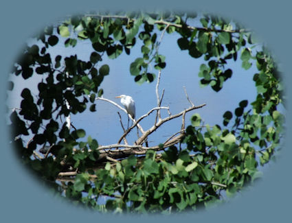
Contact Brad at Gathering Light ... a retreat Eagle Ridge Wetlands on Klamath Lake (pictured above), one of the many birding trails in Klamath Basin, not far from Gathering Light ... a retreat, rustic simplicity, a place to "Just Be", surrounded by the Fremont Winema National Forest of southern Oregon, not far from Crater Lake National Park. | |