Travel Oregon and ...
Stop for a Soak at McCredie Hot Springs
McCredie Hot Springs is located in the Cascade Mountains, approximately 10 miles east of Oakridge Oregon on the Willamette Pass, or Oregon state highway 58, as it's otherwise known.
Hwy 58 is easily accessed from I-5, on the south side of Eugene. Take the exit for Klamath Falls, and follow the signs. The route takes you along the Lookout Reservoir on the Willamette River. There are lovely seasonal waterfalls on the other side of the road. The higher your get, the smaller the Willamette gets. It's a baby up here. Oakridge is just east of the 31 mile marker. McCredie Hot Springs are just on the other side of the 45 mile marker, so if this is your destination, keep going east. Once you see the 45 mile maker prepare to turn into the parking area just on the right.
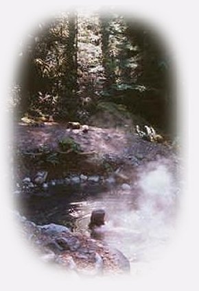
A favorite of the locals and others driving by, there are hot springs on both sides of the road. There are two large pools situated off the highwayand along side Salt Creek. Salt Creek runs fast and can be dangerous, so be careful if you have children. The water in the pools can be very hot. The temperature ranges from 98 - 114, but it's easy to find a comfortable spot. I've seen people cook eggs at the spot where the springs bubble up. The bottom of the pools are soft, composed of silt and organic material. Easy access to the pools on this side of Salt Creek make the pools very popular, but those across Salt Creek are often in use as well. Clothing is optional, so be prepared if this makes you uncomfortable. People are pretty laid back about it all though. If you want to hang around in this area specifically, Blue Pool Forest Service Campground is just west of the hot springs.
After a soak in the hot springs, continue east. You'll find hiking trails at Salt Creek Falls, in the Diamond Peak Wilderness accessed from the hiking trails at Salt Creek, hiking trails in the Waldo Lake wilderness. Beautiful Odell Lake is up here, as well as great mountain vistas, Diamond Peak and Mt Yoran, specifically.
Explore the Willamette Pass, Oregon Hwy 58, in the Willamette National Forest of the Cascade Mountains in Oregon: Hiking trails, the Waldo Lake Wilderness and the Diamond Peak Wilderness, Salt Creek Waterfalls, hiking trails to Diamond Creek Waterfalls, mountain lakes, waterfalls, fishing, boating, swimming, camping, snow skiing cross country skiing, and snow boarding at the summit, snowmobile riding and more: Directions, Map and Scenery. Want to hike or cross country ski? Try the trails at Salt Creek.
If you're heading west on the Willamette Pass, the route given on the site goes east, you might want to connect with the West Cascades National Scenic Byway. Travel Directions, Map: page 1 and page 2, and Scenery: offering mountains, hardened lava flows, wild and scenic rivers, waterfalls, hiking trails, hot springs, old growth forests, mountain lakes, forest service campgrounds.
The West Cascades National Scenic Byway provides easy access to the Three Sisters Wilderness, the Mt Jefferson Wilderness and the Mt Washington Wilderness, all located in the Willamette National Forest.
Protect our National Forests and Wilderness Areas. Leave NO Trace!
Contact the ranger station for conditions in the forest before venturing in.
Travel Oregon and northern California while staying at Gathering Light ... a retreat
located in southern Oregon near Crater Lake National Park.
|