Recreational Opportunities along Scott River
on Scott River Road in the Klamath National Forest of California
Thompkins Creek River Access
Thompkins Creek River Access is open year round, January - December. No fee is required.
Fort Jones is the closest town. When driving on California Hwy 3, turn onto Scott River Road and drive 11 miles to the Thompson Creek River Access. Campfire permits can be required. Inquire at the Ranger Station before deciding to have a fire.
There is no water for drinking and no restroom.
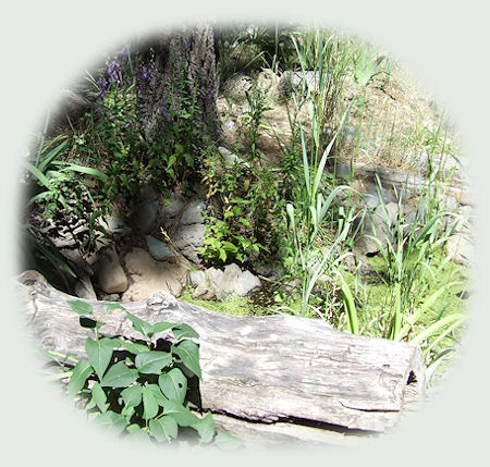
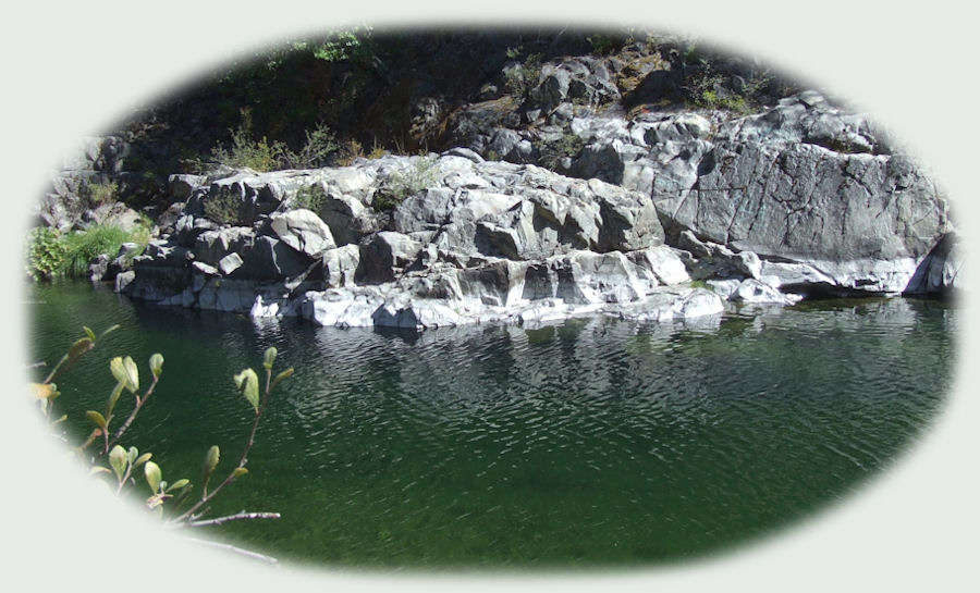
Thompkins Creek River Access is a good area for riparian wildlife, and the views overlook the rapids on the Scott River. Sometimes it's possible to see and photograph rafters.
Lovers Camp Trailhead
The Lover's Camp Trailhead is the starting point for popular hikes to Marble Valley, Sky High Lakes, Red Rock Valley, Little Elk Lake and Deep Lake. The Canyon Creek Trail connects with the Pacific Crest Trail. Be sure to park in area designated and not in campsites.
No wilderness permits are required for day or overnight stays in the marble Mountain Wilderness. A current California Campfire Permit is required to use a camp stove, barbecue or have a campfire outside developed campgrounds. Local fire restrictions supersede the campfire permit. Inquire at the Ranger Station before having a fire. No permit is required for a campfire in designated fire rings in the campground subject to local fire restrictions.
Lovers Camp Hiking trail is open from May through October. Both hiking and horseback riding is allowed. The trail is lightly used. Bring enough water for drinking, cooking and washing as well as extra water to drown campfires each day. Since, garbage pickup is NOT provided, please take all trash, garbage, fish guts and dog droppings with you when you leave. Dogs on leash only in parking lot and developed areas. Do not tie horses to trees, living or dead. Do not tie horses to corral rails or posts. Keep horses away from the creek. Avoid damage to creek bank. Fort Jones is the closest town at 24 miles away.
Water for drinking is not available, though water is available for horses. A vault toilet is provided at the trailhead.
Directions: From Ft. Jones, take the Scott River Rd for approximately 14 miles to the Indian Scotty campground. Continue on the paved road (FS 44N45) and follow the signs for 8 miles to the campground.
Jones Beach Picnic and River Access
Jones Beach Picnic area and River Access is a nice day use area on the Scott River. It's popular for swimming, other types of water play and fishing.
Jones Beach Picnic and River Access is open year round. It's marginally popular, by that I mean that the forest service rates the use of the area as moderate. I'm not surprised, considering what I had to go through to find out what this road was like before Brad decided he wanted to drive on it. I guess one must be serious about nature, about being in it and enjoying it, to take such a route as this. That's too bad, as I've stated elsewhere, Scott River is a quite beautiful and this is a lovely route. Although there is no drinking water, a vault toilet is provided.
Campfires are allowed in fire rings provided, but subject to local restrictions.
A current California Campfire Permit is required to use a camp stove, barbecue or have a campfire. Local fire restrictions supersede the campfire permit. Inquire at the Ranger Station before having a fire. There are 3 picnic sites, available on a first come, first serve basis.
Directions: From Fort Jones travel 13 miles* northwest on road 7F01/Scott River Road to the picnic site on the right.
*I got this information from the Klamath Forest Service. The Forest Service is updating the websites, and it's possible that information might be incorrect. In one place the distance from Fort Jones to Jones Creek Picnic Area and River Access is stated as 18 miles and in another it's 13 miles. Just know that you're going to come upon the site somewhere after 13 miles. :-)
As with all other sites on the Scott River, Jones Beach Picnic area and River Access is a good area for riparian wildlife. We met an interesting woman at Indian Scotty Campground. She was tent camping with her children, and she loved to get up at dawn and see what was to see. That very morning she'd seen a mother bear with 3 cubs come down into the gorge at the water edge on the other side of the river. Something I'd like to see myself. :-)
Special Designations apply for River and Stream Fishing: Regulations for the Salmon, Scott and Klamath Rivers are published in May each year in "Freshwater & Ocean Sport Fishing Supplement". The fish you'll find in the Scott River are Trout. Regarding water/flow level: Water flow in creeks and rivers fluctuate with seasons, rainfall and snow pack.
Water temperature fluctuates with seasons, flow level and water depth.
People pan for gold on the Scott River. Not so suprising, if you follow the Scott River between Callahan and Etna, California - old mining towns - you'll see all the tailings from the mining operations in the 1800s. If you want to do it today, Gold Panning on the Scott River is regulated by California Department of Fish & Game.
Boating is allowed on the Scott River. As long as it's non-motorized.
Shady Camp sites at Indian Scotty Campground
Indian Scotty campground is a good area for riparian wildlife along the river and forest birding. (See above for the story of the mother bear and her cubs coming down to the river bank at dawn.) Some small mammals frequent the campsites.
Indian Scotty campground has 28 campsites on the Scott River, as well as 1 group site that is available by reservation only. Reservations can be made online at www.recreation.gov or by phone, 1-877-444-6777. The group site costs $50 per night; the family sites cost $10 per night. The campground is open from May - October. It's not used very much. A woman tent camping with her children was the only family, or people other than Brad and I, I ever saw there. The maximum RV size is 30 feet. Camping limit 14 days. There are no accessible sites.
The closest town is Ft. Jones. Drinking Water is provided at Indian Scotty Campround, and a vault is available also. Campfires are allowed in the fire rings as provided, but this too is subject to local restrictions. All family campsites are available on a first come, first served basis. As stated previously, reservations are required for the group site.
Directions: From Ft. Jones, take the Scott River Rd for approximately 14 miles. The campground is on the right and there's a bridge on the left. (Here is a picture of the bridge,
Protect our National Forests and Wilderness Areas. Leave NO Trace.
Check with the US Forest Service on fires danger, roads and other conditions
in the forest before setting out on your journey.
|