|
Ever since I first read the autobiography, In the Land of Grasshopper's Song I wanted to to find the places described. I looked for Ishi Pishi, I found Katimin, the center of the world, Auuyich, what we today call Sugarloaf Mountain; I wanted to explore Masuhsava, the Salmon River, and Ishkeesh, the Klamath River. I wanted to be able to feel life as it was once was.
Brad and I'd traveled along the Klamath River many times on our way to the Redwoods. Then one time, seeing the sign for the Salmon River, what I was seeing clicked. If we followed that road, we'd come out at either Callahan or Etna. I knew where both of those towns were. We'd visited them more than once. So on the way back from Prairie Creek Redwoods State Park, I suggested we take a detour and check out the Salmon River. We wanted a little more information than we had, so We stopped in the towns of Willow Creek and Hoopa and asked people. Several people. Surprisingly, most knew nothing about it. One woman told me she'd never go that way. "What if you ran out of gas?" she asked. I found it interesting that that sense of the wild continued to hold on after all these years. Finally, we asked someone who did know. In Willow Creek, I believe it was, a woman at the information center was a little more forthcoming, but still not as much so as I would have liked. However, she did tell us the roads were hazardous, that one had to be aware of the potential danger of landslides. I listened to her, and thought she'd told me; I was now aware. In retrospect, considering that the weather had been quite wet for the entire length of our journey: on the coast, at the Redwoods, along the Klamath, and since I am now much more familiar with the area, I realize she was telling us we should not go along the Salmon at that time. The hazards of landslides were very real. Although the roads are paved all along the gorge, and along the Salmon and the Scott, the danger as she mentioned is now patently obvious to me. So plan accordingly.
On our first trip we unknowingly turned off of the Salmon to follow the Scott, which comes out at Callahan. I'm not including this part of the Scott as part of this tour because I need to go back during better weather. I am including the the Salmon all the way, which Brad and I love. Not that both rivers aren't beautiful. They are. But the north fork includes Sawyers Bar, and that town is an unequivocal step back into time, offering a moving photograph of life in another, more rugged era.
|
-
Begin in Weed, California*:
Weed, California, an old mill town, located at the junction of Hwy 97 and I - 5, 50 miles south of the Oregon California border. Hence a good place to begin for more than one reason. We stopped in Weed as we always do for good, wholesome food at Jim and Ellie's Espresso and Bakery. If you want to check it out, they serve an excellent veggie sandwich, and others as well, I imagine. My preference is vegetables. All sandwiches are served on their 5 Seed Bread made right there in the bakery. Most excellent. Other delights include Cappuccino, Lattes, Italian Sodas, Chai Tea, turnovers, strudel, cookies, soup and more. If you want to stop, they're located on the main drag, Weed Blvd, on right side heading south. The bakery closes at 4:30 in the summer, 4:00 in the winter, so plan ahead.
You might want to check out the gift shop. It's across the street from the bakery and just a little south. If you're interested, Weed also offers an eclectic grouping of shops in an old mercantile building. Turn east at the Chevron station, and you'll come to it on the left. It's white and certainly stands out ...
You'll find all the other offerings of life in America at the southern exit to I-5: McDonalds, Burger King, Taco Bell, Long John Silvers, a Pilot Gas Station, along with others, and more.
You need to head north however, so take a northerly heading along Weed Blvd through the main part of town and it will merge with I -5.
-
Leave I - 5 at exit 751, turn north towards Gazelle.
Brad and I like to avoid the freeways when we're on a scenic journey like this and meander. If you prefer, stay on I - 5 exit 759, find Gazelle and continue with the following directions. :-)
In Gazelle, turn on road 26 and head in a southwesterly direction on Gazelle Mountain Pass to Callahan, an old mining town, surprise. Callahan is located on the Scott River, which was heavily mined as can be readily seen by all the mine tailings. The first time I was in Callahan, we stopped at the general store, across from the old hotel, which was not a ruin then, offering a multitude of memories. It's still there, but it's definitely a ruin, windows boarded, walls caving in. It's not safe to walk on the old sidewalk, made originally for wagons, not cars ... However, the general store, located across the street, seems to be in an old feed building or something, with sidewalks also made for wagons, not cars. It was a drowsy day, that first day through. At that time we were headed for the Trinity Alps, Weaverville, and finally the Redwoods, but since we'd never been in Callahan, we sat on an old church pew on the sidewalk in front of the little store, and conversed with the owner. She had little bits of information to share, not the least being that nature had taken over those old mine tailings, and it could be quite beautiful walking through them. This is something I've yet to do, still I offer it to you now in the event such a walk has an appeal. Stop at the general store - there are two now - and ask about it.
To get where we're going on this trip, you need to drive through Callihan, heading north to Etna.
-
*If you need to cut the drive to Etna short, or if that's your preference, you can begin in Yreka, California.
Exit I - 5 at Yreka, exit 775. Take Hwy 3 in a southwesterly direction to Fort Jones.
If you want to follow the Scott River for a time, continue through Fort Jones along the river. The road will curve around, crossing the river at one point in a "U" that brings you into Greenville. At Greenville continue on Hwy 3 to Etna. If you don't care about this drive along the Scott River, take Road 12 from Fort Jones to Greenville, and that will cut off between 30 and 40 miles on your drive.
No matter how you elect to do it, you need to get to Etna and Sawyers Bar Road.
-
Etna and Scott Valley in northern California, a step back into history.
Etna, unlike Callahan, is populated. There are many old homes, and the residents I've spoken to feel a great sense of pride about their home, the area and all it has to offer. I'm including a copy of a map of a walking tour, created by the Etna Enthusiasts, for your enjoyment. Also, the Old Fashioned Soda Fountain at Scott Valley Drug, established in 1902, on Main Street is a step back into time in itself. The drugstore was once a Denny Bar store, one of the first chain stores in California. Try a lime rickey, or perhaps an old fashioned soda. I tried strawberry and it was great. Sit outside at tables on a sidewalk also built for wagons. Stop at the world renowned brewery for a brew. Etna also has a small museum operated by the Native Daughters of the Golden West. We wanted to go, but it was closed when we drove through town. If you can, don't miss it, it's located in a huge walk-in safe. Perhaps you'll have better luck. :-)
-
Heading out for Sawyer's Bar and the Salmon River:
Travel in a southwesterly direction on road 37, otherwise known as Sawyers Bar Road. Nature shows many of her charms here. If you're like me, you'll stop and take photograph after photograph, not realizing that what you're seeing here, although lovely, is simply a precursor of what is yet to come. Indeed, I have a 256 mg photo card for my camera, and I filled it up long before I finished this trip. Brad too, although his card is only 128 mg.
We stopped at a little creek, walked along the bank for awhile. Then moved on.
These are the Salmon Mountains here. Ancient terrane accreted to the western coast of North America when the continent collided with an island arc somewhere in the ocean offshore. Much interesting geology in northern California and southwestern Oregon if you're interested.
Coming off the summit for Etna Mountain, check out the steep, mountainous terrain, and before long, you'll see the sign for the road that leads to the trailhead for Taylor Lake on the left - obviously, it would be quite hazardous to go the right at this point. :-). There are many trails here. The shortest and most easily accessible is the one to Taylor Lake. If you want to see more, take the jog in the trail to Smith Lake. Also, hike around Taylor lake and take the trail to Hogan Lake. The trail to Smith Lake connects with the Pacific Crest Trail not too long before you get to Smith Lake. Hang around if you like. The hike to Taylor Lake isn't very long, and it would be quite easy to pack camping gear in there, along with a rubber raft and spend a most enjoyable time.
-
On to Sawyer's Bar and the gorge
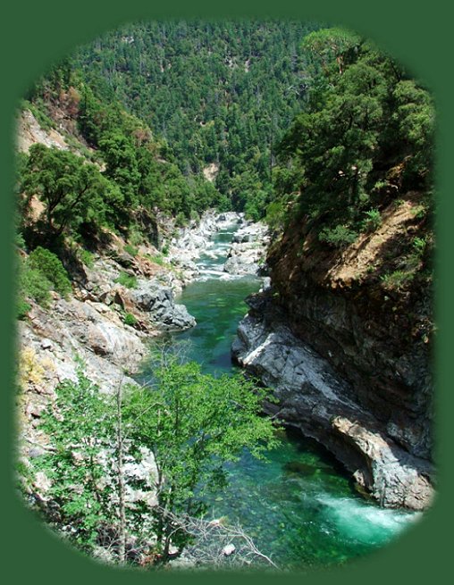
There is much to see on this route. Stop as you wish, but keep in mind you might want to do more than just drive through Sawyer's Bar when you get there. As the plaque in front of the old town hall states, "The most noteworthy features [of the town] are the century old frame buildings and the famous Catholic Church." That's not taking into account the river, for the Salmon River comes into view just before Sawyer's Bar. Continue as you will. The river is studded with interesting sites: an old suspension bridge, beautiful Madrone trees, that's if the tent caterpillars infecting all the trees north of the border in Oregon haven't made their way down south. Check out the interesting signs for mining claims. People still pan on the river; they dive for gold. An interesting man spoke to us, he'd been diving for gold for years. All the while, keep in mind that you'll likely want to spend a great deal of time on the gorge. Once you come to the community Forks of the Salmon, you'll know the gorge is at hand. Still, take some time to check out this town. Colorful people live on this river. :-)
The road on the gorge is narrow. This is not a highway by any means. There's not a lot of traffic, however, so it's possible to stop right on the road to look at a view that catches your eye if you want. I once had someone give me a dirty look for this. I suppose the natives get tired of tourists, but it's amazingly beautiful, and if you don't mind, stop and take it all in.
The Salmon River flows into the Klamath River at Somes Bar. These are names right out of history. Names I recognized as an adult, the first time Brad and I took Hwy 196 on the Klamath River to the Redwoods on the California coast. I must have learned about them when I was a child, studying the California gold rush. Like the Salmon, the Klamath River was occupied by miners up and down much of its expanse.
Stop in the general store at Somes Bar if you want any information about the route. Also, drive around the general store, following the road to the right, and you'll come down to the bridge over the Klamath offering a view of the confluence of both the Salmon and the Klamath Rivers. In the past ten years the Karuk Indians have placed signs indicating different sights of significance in their history. I didn't have this advantage the first time I went looking for places referred to in the book, In the Land of Grasshopper Song. But Sugarloaf mountain, sacred to the Karuks, can be viewed from the bridge as well.
If you're heading to I - 5, or perhaps you want to take the route along the Scott River, travel east along Klamath River, take in the sights and history. If you've a mind for it, try rafting. These are easy rapids, and barring any unforeseen difficulties, should be no problem. Travel west if you want to go to the Redwoods.
|