travel california 
in the klamath national forest along the scott river - begin at Fort Jones, turn north on scott river road to come out on the klamath river just southwest of horse creek on California hwy 96.

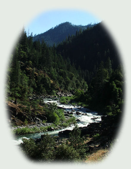
The beautiful Scott River
in the Klamath National Forest, California

If you want to follow the Scott River through the Marble Mountains, begin at Fort Jones, California. Turn on Scott River Road. You'll come out between Hamburg, California on the Klamath River, Hwy 196, and Horse Creek. By the same token, if you're traveling along the Klamath River, turn left southwest of Horse Creek when you're travling downstream on the Klamath River, or right a little northeast of Hamburg, California when you're traveling upstream on the Klamath River.

Forward ~ ... a palisade of trees sheltering
the lovely Scott River.

Back ~ ... the old west lives on ... Hamburg Store - Hotel

USFS: Campgrounds, trails for hiking, mountain biking and horseback riding in the Klamath National Forest of California and Oregon.

Explore the Northern California: The Scott River; the Shasta Trinity area: Scenery, hiking, mountain biking, sightseeing: mountains, waterfalls, rivers and more: Travel Directions, Map and Scenery.

Protect our National Forests and Wilderness Areas. Leave NO Trace!

... and how did we find this route on the Scott River?

We were driving around in northern California. I can't remember where we were going specifically, but I saw a sign that said, "Scott River Road". We knew the Scott River on the other end, down by Callahan, California. We wanted to see this section of Scott River. I wanted to do it right then, but Brad said we should find out more about the road first. Having suffered considerably when taking a gravel road across Hart Mountain to French Glen in Oregon once, he's not as daring as he used to be. So we took another route that day, went home, and I had the ornerous task of finding out if Scott River Road was paved. So funny too, for so few people had ever taken it, or even knew about it. That reminded me of the time Brad and I were driving along the Klamath River, on our way to the Redwoods, and stopped at Somes Bar to see the confluence of the Salmon and Klamath Rivers. Having read the most interesting tale of two white women Indian matrons in Karuk country, I was most interested in checking out all the sights. At that point, I wanted to see Ishi Pishi. These sights weren't marked then, as they are now. So it was a kind of adventure, going by the information in the book, trying to figure it out. Anyway, when we left Somes Bar, heading west, I saw the road that had to follow the Salmon River and the sign said we'd find Callahan and Etna at the end. We knew where those towns were, and we knew where we were. We decided to take this route on our return journey. Again, however, Brad said we had to find out about it before we did. So we stopped in towns along the Klamath River and asked. Interestingly, the area still had that aura of mystery. One woman said she'd never go that way for she might run out of gas. There were other such responses as this. Finally, we spoke to a woman who knew. She did tell us there was a danger of avalanche. We didn't know she meant that very day, and later I realized that that was indeed what she'd meant. But we made it safely.

travel california 
in the klamath national forest along the scott river - begin at Fort Jones, turn north on scott river road to come out on the klamath river just southwest of horse creek on California hwy 96.

Anyway, the people we spoke to that day when I first saw the sign for Scott River Road, and the responses we got were vague. When we got home I started looking online. I mailed several people at different organizations. Finally a woman who worked for CalTrans was familiar with the road. She hadn't been down it in years and said it was very winding, which it is, but then we knew it was paved, and that was what Brad wanted to know. So we took off, following a winding road that is ever so beautiful having much to recommend it. I would never give up on it, but that's for love of nature. :-)

Recreational Opportunities along Scott River
on Scott River Road in the Klamath National Forest of California

Thompkins Creek River Access

Thompkins Creek River Access is open year round, January - December. No fee is required. Fort Jones is the closest town. When driving on California Hwy 3, turn onto Scott River Road and drive 11 miles to the Thompson Creek River Access. Campfire permits can be required. Inquire at the Ranger Station before deciding to have a fire. There is no water for drinking and no restroom.

Thompkins Creek River Access is a good area for riparian wildlife, and the views overlook the rapids on the Scott River. Sometimes it's possible to see and photograph rafters.

Lovers Camp Trailhead

The Lover's Camp Trailhead is the starting point for popular hikes to Marble Valley, Sky High Lakes, Red Rock Valley, Little Elk Lake and Deep Lake. The Canyon Creek Trail connects with the Pacific Crest Trail. Be sure to park in area designated and not in campsites.

No wilderness permits are required for day or overnight stays in the marble Mountain Wilderness. A current California Campfire Permit is required to use a camp stove, barbecue or have a campfire outside developed campgrounds. Local fire restrictions supersede the campfire permit. Inquire at the Ranger Station before having a fire. No permit is required for a campfire in designated fire rings in the campground subject to local fire restrictions.

Lovers Camp Hiking trail is open from May through October. Both hiking and horseback riding is allowed. The trail is lightly used. Bring enough water for drinking, cooking and washing as well as extra water to drown campfires each day. Since, garbage pickup is NOT provided, please take all trash, garbage, fish guts and dog droppings with you when you leave. Dogs on leash only in parking lot and developed areas. Do not tie horses to trees, living or dead. Do not tie horses to corral rails or posts. Keep horses away from the creek. Avoid damage to creek bank. Fort Jones is the closest town at 24 miles away. Water for drinking is not available, though water is available for horses. A vault toilet is provided at the trailhead.

Directions: From Ft. Jones, take the Scott River Rd for approximately 14 miles to the Indian Scotty campground. Continue on the paved road (FS 44N45) and follow the signs for 8 miles to the campground.

Jones Beach Picnic and River Access

Jones Beach Picnic area and River Access is a nice day use area on the Scott River. It's popular for swimming, other types of water play and fishing.

Jones Beach Picnic and River Access is open year round. It's marginally popular, by that I mean that the forest service rates the use of the area as moderate. I'm not surprised, considering what I had to go through to find out what this road was like before Brad decided he wanted to drive on it. I guess one must be serious about nature, about being in it and enjoying it, to take such a route as this. That's too bad, as I've stated elsewhere, Scott River is a quite beautiful and this is a lovely route. Although there is no drinking water, a vault toilet is provided.

Campfires are allowed in fire rings provided, but subject to local restrictions. A current California Campfire Permit is required to use a camp stove, barbecue or have a campfire. Local fire restrictions supersede the campfire permit. Inquire at the Ranger Station before having a fire. There are 3 picnic sites, available on a first come, first serve basis.

Directions: From Fort Jones travel 13 miles* northwest on road 7F01/Scott River Road to the picnic site on the right.

*I got this information from the Klamath Forest Service. The Forest Service is updating the websites, and it's possible that information might be incorrect. In one place the distance from Fort Jones to Jones Creek Picnic Area and River Access is stated as 18 miles and in another it's 13 miles. Just know that you're going to come upon the site somewhere after 13 miles. :-)

As with all other sites on the Scott River, Jones Beach Picnic area and River Access is a good area for riparian wildlife. We met an interesting woman at Indian Scotty Campground. She was tent camping with her children, and she loved to get up at dawn and see what was to see. That very morning she'd seen a mother bear with 3 cubs come down into the gorge at the water edge on the other side of the river. Something I'd like to see myself. :-)

Special Designations apply for River and Stream Fishing: Regulations for the Salmon, Scott and Klamath Rivers are published in May each year in "Freshwater & Ocean Sport Fishing Supplement". The fish you'll find in the Scott River are Trout. Regarding water/flow level: Water flow in creeks and rivers fluctuate with seasons, rainfall and snow pack. Water temperature fluctuates with seasons, flow level and water depth.

People pan for gold on the Scott River. Not so suprising, if you follow the Scott River between Callahan and Etna, California - old mining towns - you'll see all the tailings from the mining operations in the 1800s. If you want to do it today, Gold Panning on the Scott River is regulated by California Department of Fish & Game.

Boating is allowed on the Scott River. As long as it's non-motorized.

Shady Camp sites at Indian Scotty Campground

Indian Scotty campground is a good area for riparian wildlife along the river and forest birding. (See above for the story of the mother bear and her cubs coming down to the river bank at dawn.) Some small mammals frequent the campsites.

Indian Scotty campground has 28 campsites on the Scott River, as well as 1 group site that is available by reservation only. Reservations can be made online at www.recreation.gov or by phone, 1-877-444-6777. The group site costs $50 per night; the family sites cost $10 per night. The campground is open from May - October. It's not used very much. A woman tent camping with her children was the only family, or people other than Brad and I, I ever saw there. The maximum RV size is 30 feet. Camping limit 14 days. There are no accessible sites. The closest town is Ft. Jones. Drinking Water is provided at Indian Scotty Campround, and a vault is available also. Campfires are allowed in the fire rings as provided, but this too is subject to local restrictions. All family campsites are available on a first come, first served basis. As stated previously, reservations are required for the group site.

Directions: From Ft. Jones, take the Scott River Rd for approximately 14 miles. The campground is on the right and there's a bridge on the left. (Here is a picture of the bridge,

Travel Oregon and northern California while staying at Gathering Light ... a retreat
located in southern Oregon near Crater Lake National Park.

Travel to Gathering Light ... a retreat from northern California, see mountains, mountains, mountains, rivers, Mt Shasta, Castle Crags, hike to waterfalls, along the Sacramento River and more: Directions, Map and Scenery.

Directions to and Day Trips in either Oregon and California of about 100 miles from the retreat.

Little known Scenic Places: hiking with or without trails, birding trails, river canyons, gorges, wetlands, national wildlife refuges and more near Crater Lake and the retreat: Travel Directions, Map and Scenery.

Website Directory      Page Listings      Home Page

Contact Brad at Gathering Light ... a retreat.

Cabins in the forest at Gathering Light ... a retreat located in southern Oregon near Crater Lake National Park.

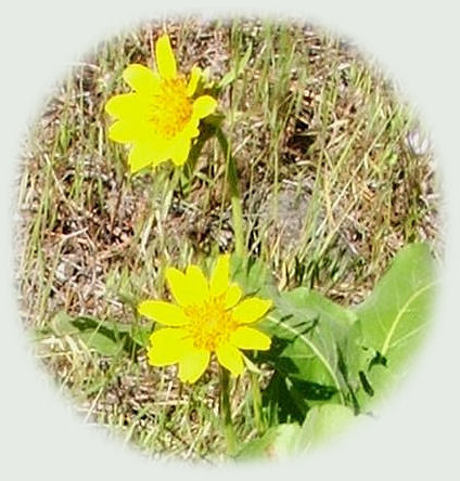
Wildflowers a-bloom, walking along the river (pictured above) at Gathering Light ... a retreat. Rustic simplicity, a place to "Just Be", Gathering Light is nestled on the banks of the river, surrounded by the Fremont Winema National Forest of southern Oregon, and not far from Crater Lake National Park.